
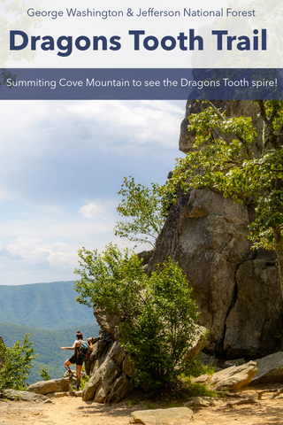
Amongst the most iconic landmarks on the Appalachian Trail, McAfee Knob is a bucket list destination for hikers from around the world. Located in Virginias Blue Ridge, McAfee Knobs 3,200 foot summit features postcard worthy views of the Catawba Valley, Roanoke Valley, and North Mountain. This is one of the toughest northbound sections of the Appalachian Trail with a 4.4 mile hike that ascend over 1,700 feet from its trailhead on VA-311. McAfee Knob is the second stop along Virginias Triple Crown Loop which includes nearby Dragons Tooth and Tinker Cliffs.
McAfee Knob Trail | 4.4 Miles
McAfee Knob Trail Map | AllTrails
McAfee Knob Trailhead Location | Google Maps

Route to McAfee Knob along the Appalachian Trail from the VA-311 trailhead.
Getting There
If you’ve never heard of Virginias Triple Crown well then you’re in for a special treat! Consisting of three of the regions most spectacular overlooks, Dragons Tooth, McAfee Knob, and Tinker Cliffs, this 38.5 mile loop within the George Washington & Jefferson National Forests is a bucket list hike that should be on every serious hikers must do list. Gaining over 6,874 ft in elevation, it crosses over 6 mountain peaks while overlooking the stunning Catawba Mountain Valley. Even if you’re not ready to tackle this monumental 3 day hike, you can still visit each of these iconic landmarks via direct out and back trails that will give you all of the benefits without the blisters. Centered around the city of Roanoke, the McAfee Knob Trail kicks off from a fairly large trailhead on VA-311 just south of the Dragons Tooth Trailhead. With 50,000 annual visitors, this trailhead parking lot is always full so several outfitters offer prearranged shuttle services to and from nearby overflow lots at the Catawba Center & Catawba Sustainability Center.

The VA-311 trailhead for McAfee Knob. Note that from the parking lot hikers must cross the highway to the small trail visible going up into the woods.

The McAfee Knob Trail doesn't officially exist, but is a route that follows the Appalachian Trail to the summit of McAfee Knob and its famous ledge. Make sure to take a photo is this map at the trailhead.
McAfee Knob Trailhead (4.4 miles \ 8.8 miles roundtrip)
This 8.80 mile roundtrip hike starts off by joining the Appalachian Trail as it crosses VA-311 from the parking lot, north into the woods directly across the street. There is a marked crosswalk with flashing hazard lights to make oncoming traffic aware of pedestrians, but this is a fairly busy highway so use caution while crossing. Because of its popularity, the National Park Service has rangers stationed here during the busy summer season to aid hikers with directions and answer questions related to the trail. It is a quick ascent from the road to the Catawba Mountain Ridge which serves as the main route up to McAfee Knob. Within the first 0.25 mile you will reach an informational kiosk with a map of the full trail and a few options for how you would like to continue. There is no official McAfee Knob Trail as it is simply a natural landmark found along the Appalachian Trail. With that being said there are several hiking apps and websites that have maps detailing how to reach this point.

Leaving VA-311 you'll follow the Appalachian Trail up to the crest of Catawba Mountain.

This informational kiosk a quarter of a mile into the hike is where the fire road (a.k.a. McAfee Knob Trail) and the Appalachian Trail diverge. Take a left turn onto the fire road for a faster and less strenuous journey up to McAfee Knob.
Trailhead to Appalachian Trail Junction (2.6 Miles)
There is no right or wrong way to hike to the top of McAfee Knob, but there is an easy and a hard way to do it. As stated earlier, there is no official McAfee Knob Trail as it is simply a natural landmark found along the Appalachian Trail. Because of this there are two popular routes that hikers use to reach it while hiking northbound on the AT. Traditionalist may want to take a RIGHT TURN at this kiosk and continue downhill along the Appalachian Trail. This route is more strenuous and adds an additional 0.5 mile to the hike. An upside is that you will get to see many of the AT’s historic sites such as Johns Spring Shelter and the Catawba Mountain Campsite. If you’re mainly interested in seeing McAfee Knob then the LEFT TURN might be for you. Following the crest of Catawba Mountain, this maintained fire road, dubbed The McAfee Knob Trail, offers a more direct path and gradual incline up to the knob. Seeing as this was our main objective for the afternoon, we opted for the more direct route along the fire road and took a LEFT TURN here.

The fire road dubbed "The McAfee Knob Trail" shaves off nearly 0.25 mile off the hike up to McAfee Knob and has a more gradual incline than the Appalachian Trail.

One of many overlooks along the Catawba Mountain Crest just behind this large rock formation.
From the informational kiosk, it is a 2.60 mile trek to where the McAfee Knob Trail ends and you must hop back on the Appalachian Trail for the rest of the journey. One of the few advantages of staying high up on the ridge is the fact that there are several small trails leading out to craggy overlooks all along the entire path. The most popular of these lookouts appears just on the other side of a large rock outcropping within the first few minutes. Some people take to scrambling onto the boulders to get a clearer view from high up. Another major landmark on this trail that’s not to be missed is the Catawba Mountain summit at an elevation of 2,363 feet. This summit makes up the left shoulder of McAfee Knob. An added benefit of the fire road is its profusion of spring wildflowers and its vibrant fall foliage.

Keep an eye out for this chain across the fire road marking its junction with the Appalachian Trail. Take a left turn here to continue up to McAfee Knob.

From the Appalachian Trail junction it's a 1.3 mile hike to the summit of McAfee Knob. Crossing under the massive power lines marks the halfway point.
Appalachian Trail Junction to McAfee Knob (1.3 Miles)
While the fire road continues much further past McAfee Knob, you must keep an eye out for where the Appalachian Trail crosses the fire road as this is our exit point. The Forest Service has put up a chain directly where this junction is to keep hikers from going any further and missing this LEFT TURN. From here on out begins a challenging 800 foot ascent up a series of switchbacks to the summit of McAfee Knob. Spaced out over a 1.30 mile stretch, the rocky path traces up the steepest ridge on Catawba Mountain to an open meadow below a high-voltage power line. The first real juicy overlooks of Catawba Valley can be found via small side trails just past this point. From the clearing it is another 0.50 mile to the summit.

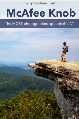
The famous ledge atop McAfee Knob. Visitors can see every nook and cranny of the Catawba Valley and North Mountain to the west, Tinker Cliffs to the north, and Roanoke Valley to the east
McAfee Knob
|
As the trail gets closer and closer to McAfee Knob, you’ll notice the tree canopy dwindling as we enter the stunted pine and heath forest that dominates the summit. Up until the mid 1900’s much of what you see surrounding you was open farmland worked by generations of settlers that arrived in The Catawba Valley during the 1730’s. The knob itself was named after one of these Scottish-Irish pioneers, James McAfee. During late summer, the low bush blueberries found along this stretch of trail make for an amazing mid-day snack. While the Appalachian Trail travels over the 3,186 foot summit of McAfee Knob, it does not go directly over its famously photographed ledge. Keep an eye out for a small side trail known as the McAfee Knob Spur Trail. |

This is a bucket list hiking destination known worldwide so chances are the summit is going to be packed with tourists.

If you want to skip the crowds opt for an early morning sunrise hike or visit during winter when you'll have the scenery all to yourself.
This 0.1 mile path travels out to the sheer cliffs on the northern rim of McAfee Knob to view the cantilever ledge. Jutting out like a giant diving board, this style of ledge is only one of two found along the entire AT with the other being Pickens Nose in the Southern Nantahala Wilderness. From photographs it appears to be a thin and fragile piece of rock that people ominously stand on, but in person it is actually very large and securely attached to the rest of the mountain. Standing on the tallest peak in the region, the 270 degree panoramic views from up here are astounding. Visitors can see every nook and cranny of the Catawba Valley and North Mountain to the west, Tinker Cliffs to the north, and Roanoke Valley to the east. The only thing that could make this even more special would be an early morning hike up here to see one of the famous McAfee Knob sunrises.

The most photographed landmark along the Appalachian Trail. Chances are if you've heard of McAfee Knob, you've probably seen a photo that looks identical to this.
Up next, we’re traveling east of Roanoke to catch a glimpse of one of the more famous state parks in Virginia. Once owned by Thomas Jefferson and listed on the National Register of Historic Places, the 215-foot tall Natural Bridge is the tallest natural arch in the Southeast United States. More than just a bridge, Natural Bridge State Park is surrounded by beautiful forests, rolling meadows, and the limestone gorge carved out by Cedar Creek. Accessed via 7 miles of hiking trails, visitors can explore a rebuilt Monacan Indian Village, several caves, and the 30 foot tall Lace Falls. Stay tuned for this upcoming article and as always, see y’all on the trail!


0 comments