
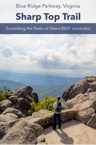
Preserved as part of the Blue Ridge Parkway, the Peaks of Otter is one of the oldest and most beloved recreation sites in all of Virginia. Made up of Sharp Top, Flat Top, and Harkening Hill, these peaks were once thought to be amongst the tallest in North America. Visitors to the area can summit the 3,875 ft peak of Sharp Top Mountain along a 2.9 mile trail to several overlooks at the historic stone shelter, Buzzards Roost, and the summit pinnacle. Historically significant as it marked the northernmost boundary of the Cherokee Nation, a piece of Sharp Tops summit was included in the building of the Washington Monument in the nations capitol.
Sharp Top Trail | 2.9 Miles
Peaks of Otter Trail Map | NPS
Sharp Top Trailhead Location | Google Maps

Approximate route of Sharp Top Trail in the Peaks of Otter.
Getting There
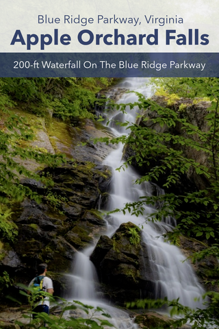
As part of an extended tour of the Roanoke Valley in Southwestern Virginia, climbing the Peaks of Otter was my last stop of the weekend after taking time to check out the nearby Dragons Tooth and McAfee Knob Overlooks on the Appalachian Trail, visiting the tallest arch in the Southeast at Natural Bridge State Park, and hiking down off the Blue Ridge Parkway to see the rare 200-foot Apple Orchard Falls. The Peaks of Otter is one of the most popular and beloved recreation areas in all of Virginia. Within its 4,200 acres, this National Park Service property contains a lodge, campground, visitors center, picnic area, 42-acre lake, and 15 miles of hiking trails. The 1.5 mile Sharp Top Trail ascends 1,300 vertical feet through the forests on Sharp Top Mountain to three separate overlooks with spectacular 360 degree views of the Peaks of Otter and surrounding landscape. Visitors can find the Sharp Top Trail shortly after entering the Peaks of Otter Recreation Area on Milepost 85.6 of the Blue Ridge Parkway. Turn off the Blue Ridge Parkway onto Peaks Road, which merges into Sheep Creek Rd and park in the Sharp Top Store parking lot at the base of Sharp Top Mountain. The Sharp Top Trailhead is located directly behind the store.

Sharp Top Mountain from the Blue Ridge Parkway as you enter the Peaks of Otter.
Peaks of Otter (Milepost 85.6)
There is no mistaking the Peaks of Otter once you see it. While driving south on the Blue Ridge Parkway, the peaks first come into view shortly after driving past the Falling Water Cascades parking lot (also part of the Peaks of Otter). The Blue Ridge Parkway itself drives straight through the heart of this bowl shaped valley surrounded by the three imposing peaks of Sharp Top, Flat Top, and Harkening Hill. Originally marking the northernmost boundary of the Cherokee nation, the area surrounding the Peaks of Otter in particular has attracted hikers for hundreds, if not thousands of years. Though we will be focusing on summiting the Sharp Top Mountain Trail on this trip, visitors with more time can also explore the 3.3 mile Harkening Hill Loop directly behind the Visitors Center or the 4.4 mile Flat Top Mountain Trail which summits the tallest summit in the Peaks of Otter and connects with the 1.7 mile Falling Water Cascades Trail.

Trailhead for the 1.5 mile Sharp Top Trail located behind the Sharp Top Store in the Peaks of Otter.

From the get-go it is a breeze to hike along the clear and gradually graded path, but pretty soon we will be ascending 1,300 vertical feet.
Sharp Top Trail (2.9 miles out & back)
The Sharp Top Trails short 1.5 mile length is one of the more strenuous in the area, but packs a huge payoff for those willing to undertake it. From the base of this 3,875 ft mountain, we will be hiking almost straight up the northern slope of Sharp Top to three separate overlooks. The Buzzards Roost is a rocky outcropping just below the main summit with views extending southwest towards Roanoke. Just above that is a series of lookouts surrounding a historic stone shelter built by the National Park Service and the C.C.C. in the 1930’s. Following a curving set of stairs above the shelter, visitors will reach the main and most dramatic overlook atop the very tip of Sharp Top Mountain. The start of this journey begins with an idilic walk through the woods as we depart the general store and begin our ascent from the base of Sharp Top Mountain. The mostly dirt trail here has a nice gradual grade which makes it a breeze to traverse.

After crossing the bus shuttle road, the Sharp Top Trail begins its straight shot up the mountain towards Buzzards Roost.

One of nearly a dozen staircases scattered throughout the mountain.
At the 0.25 mile mark, you’ll cross a freshly paved road that winds its way up the northern slope of the mountain, but is closed off to hikers. During the summer season, a local outfitter runs shuttle services from the general store to a bus station located near the summit of Sharp Top Mountain. Visitors can pay a small fee to skip the rigors of the main hike and get a ride to just 200 feet shy of the summit. On the day of our hike it was a holiday weekend so the shuttle service was unavailable. After crossing the road, the trail becomes much steeper and rockier as we work our way up the western side of Sharp Top. At the 0.75 mile mark, the trail gives way to a near vertical incline up a rough set of stone steps. This in turn leads to another even steeper section of trail made up of loose gravel that ascents to two more stairways as we approach the Buzzards Roost. In total from the start of the hike to Buzzards Roost it is a total of 800 feet in elevation gain.

In total from the start of the hike to Buzzards Roost it is a total of 800 feet in elevation gain.

On February 2, 1943, a B-52 flying a nighttime navigation training mission crashed at 3,100 feet on the side of Sharp Top Mountain. All five crew members aboard the plane were lost in the tragic accident. The crash site is so remote and difficult to get to that it was never removed and the wreckage can still be seen to this day
Buzzards Roost Overlook
The trail pauses its ascent on a saddle connecting Sharp Top Mountain to the smaller peak of Buzzards Roost. There is an intersection here giving hikers an option to turn right for Buzzards Roost 600 feet away. It only takes several minutes to reach a clearing in the woods and the rocky outcropping atop Buzzards Roost 3,525 ft peak. This overlook faces south and west into the Piedmont and has excellent views of the Blue Ridge Mountains in its own right. Directly ahead is a wide valley with Taylors Mountain on the right and the small hill of Sharps Mountain on the left. On February 2, 1943, a B-52 flying a nighttime navigation training mission crashed at 3,100 feet on the side of Sharp Top Mountain. All five crew members aboard the plane were lost in the tragic accident. The crash site is so remote and difficult to get to that it was never removed and the wreckage can still be seen to this day. A memorial was erected at the site and veterans make regular pilgrimages to the crash site in remembrance. If you look north you’ll notice a line of staggered boulders sticking up out of the forest canopy extending up to the summit of Sharp Top Mountain. This is the continuation of the trail.

It is another 400 ft ascent from Buzzards Roost to the summit of Sharp Top Mountain through a maze of paths criss crossing the boulder field on top of the mountain.

Visitors can pay a small fee to skip the rigors of the main hike and get a ride to just 200 feet shy of the summit.
Stone Shelter Overlooks
Leaving Buzzards Roost, we pass the trail junction and continue straight across the gap for the last 0.75 mile walk to the summit of Sharp Top. The entire summit of made up of a series of massive rock outcroppings with trails that we’ve in and out of them like a maze. This is the flattest part of the entire hike and it is short lived as we near the base of the massive boulders. Here, we begin the last 400 foot ascent up a spiraling set of stone steps which leads to another higher elevation meadow atop the mountain. Another set of stairs weaves in and out of crags in the boulders to a trail junction just before reaching the open summit. A left turn at this intersection leads directly down the north slope of Sharp Top to the bus station.
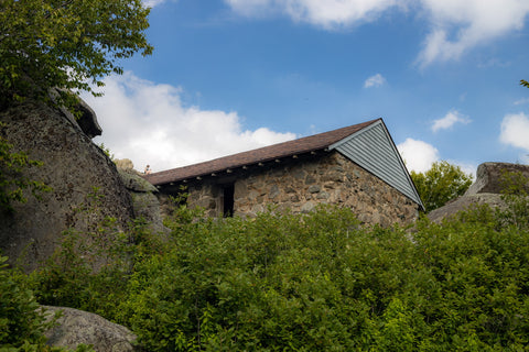
Initial view of the historic stone shelter atop Sharp Top Mountain.

If you were to blind fold someone and drop them off here, they would think they were in the Swiss Alps.
At this point the roof of the stone shelter should be visible as you make the final approach to the summit. It came as a complete surprise to come upon this building on our visit as I had not heard any mention of it while researching this hike. Tucked in between the rock outcrops, the building is surrounded by a wild garden of heathers and blueberry bushes, which frame distant mountain views in every direction.

This would make a great place to hide out from a storm while hiking up the mountain.

Looks like a medieval European village, but alas we are in Virginia.

The first of three huge overlooks from atop Sharp Top Mountain. This one os directly past the stone shelter.
This historic stone shelter dates back to the 1930’s when the National Park Service initially begin developing the Peaks of Otter during construction of the Blue Ridge Parkway. The building has several large windows giving it plenty of light and a wood burning fireplace with a chimney. If you were to randomly blindfold someone and drop them off here without any prior knowledge of their destination, they would think they were in the Swiss Alps.

A final series of staircases leads up from the stone shelter to two more overlooks and the pinnacle of Sharp Top Mountain.

The second overlook right above the stone shelter and easily the most dramatic overlook in Virginias stretch of the Blue Ridge Parkway.
Sharp Top Mountain Summit
A few short steps past the historic shelter, you’ll encounter the first of several stone terraces, built up one over the other, all the way to the pinnacle of Sharp Top Mountain. The first overlook directly behind a towering stone staircase is easily the most popular. Here, you get the typical view seen the world over of the Peaks of Otter. The lodge and Abbott Lake take center stage at the bottom of the valley with the 3,353 ft Harkening Hill directly behind that. A quick walk up the stairs from this spot will land you on a second terrace where the views really begin to open up far and wide. This one is part of the stairway up to the pinnacle of Sharp Top Mountain that can be seen all the way down from the Blue Ridge Parkway. Built into the rock outcrop atop Sharp Tops summit, the third and final terrace is truly special. If anyone has ever wondered what it’s like to stand on top of a mountain, this is literally that very experience. You could spin your head an entire 360 degrees and have a clear line of sight across the region for miles.

The image most associated with the Peaks of Otter. Directly below is Abbott Lake and the Peaks of Otter Lodge with Harkening Hill to the left.

Just look at that view! This made the strenuous journey up to Sharp Top Mountain totally worth it.

The last overlook on top of Sharp Top Mountains Pinnacle. Simply jaw dropping.
Pictures don’t do this hike any justice, so you’ll simply have to make the trek out to the Peaks of Otter and see it all for yourself. If you’ve never given any though to exploring the abundant natural beauty of Virginia, then search our archives for some inspiration for your next trip. Some of our personal favorites in the far southwestern corner of the state are hiking the Elk Garden Trail which is the gateway to Mount Rogers (the highest peak in Virginia). Grayson Highlands State Park with its dramatic landscape surrounded by towering mountains, cascading waterfalls, and wild ponies is an unbeatable destination. Those looking for something simpler and family friendly can drive over to check out the longest continuous tunnel in the U.S. at Natural Tunnel State Park. Stay tuned to all of our upcoming articles and as always, see y’all on the trails!


0 comments