
The 200-feet tall Apple Orchard Falls is one of the tallest and most photographed waterfalls in the Shenandoah Valley. Located along Virginias’ Blue Ridge Parkway, this 2.9 mile trail can be reached from the Sunset Field Overlook parking lot on milepost 78. A popular side trip for thru-hikers, this waterfall is accessible from the Appalachian Trail as it traverses the Backbone Ridge near Floyd Mountain, Apple Orchard Mountain, and the Cornelius Creek Shelter. Designated as a National Recreation Trail, this is one of the more picturesque and popular trails in the George Washington & Jefferson National Forests.
Apple Orchard Falls Trail | 2.9 Miles
Apple Orchard Falls Trailhead Location | Google Maps

Approximate 2.9 mile route of Apple Orchard Falls Trail from the Sunset Field Overlook on the Blue Ridge Parkway.
Getting There
Sweeping mountain vistas and giant waterfalls await on this unique hike along Virginias Blue Ridge Parkway. In a state lacking many large waterfalls, Apple Orchard Falls enormous 200-foot drop is something of a rarity and worth seeking out. As part of the centerpiece to my trip exploring the Roanoke Valley, I also made time to check out the nearby Dragons Tooth and McAfee Knob Overlooks on the Appalachian Trail, tour the tallest arch in the Southeast at Natural Bridge State Park, and scaled the Peaks of Otter to catch one of the best views in the region from the top of Sharp Top Mountain. Apple Orchard Falls has several access points that can be connected to create an amazing day hike which earned it the honor of being designated a National Recreation Trail. While the falls can be reached from both the Appalachian Trail and Cornelius Creek Trail, the most commonly used trailhead is from the Sunset Fields Overlook on Milepost 78.4 of the Blue Ridge Parkway.

Apple Orchard Falls Trailhead from the Sunset Field Overlook. This waterfall has several different access points including one from the Cornelius Creek Trail at the bottom of the valley and another from the Appalachian Trail. Check out those views in the background.

The name apple orchard was coined from all of the gnarled and heavily weathered trees located in the area, which resemble that of an ancient orchard.
Apple Orchard Falls Trailhead from
Sunset Fields (Milepost 78.4)
Approaching the tallest peak on the Blue Ridge Parkway, Apple Orchard Mountain, the parking lot for Sunset Field will be on your right if you’re heading south. Named for early settlers, Sunset Field offered boys at the summer resort of Camp Kee-wan-zee a place to enjoy the sun and see starry skies on a cloudless night. The name apple orchard was coined from all of the gnarled and heavily weathered trees located in the area, which resemble that of an ancient orchard. Today, this is used as the official trailhead for the 2.9 mile Apple Orchard Falls Trail and as an access point for the nearby Appalachian Trail. Generally considered a challenging route with an elevation gain of 1,700 feet, it takes an average of 2 hours to complete this hike. From the trailhead it is a straight shot down the southwestern slope of Apple Orchard Mountain to a sheer cliff from where this magnificent waterfall tumbles over.

Generally considered a challenging 2.9 mile route with an elevation gain of 1,700 feet, it takes an average of 2 hours to complete this hike from the Sunset Field Overlook.

From the start, it is a quick 0.30 miles to where the Apple Orchard Falls Trail intersects with the Appalachian Trail at the first of two junctions. Keep going straight past this intersection.
Apple Orchard Falls Trail (2.9 miles)
While you won’t find any apples here, the fields surrounding the trailhead kiosk are surrounded by fruiting brambles during late summer. This is one of the best views from the Blue Ridge Parkway looking north towards the town of Buchanan and Purgatory Mountain. The ridge top vistas abruptly disappear however, as we head under the tree canopy to begin our descent through this enchanting woodland landscape. Steeply graded most of the way down, this trail is somewhat of a breeze to hike down as long as you can avoid tripping over the tree roots and rocks. From the start, it is a quick 0.30 miles to where the Apple Orchard Falls Trail intersects with the Appalachian Trail at the first of two junctions. At the intersection continue straight. This is where Apple Orchard Creek will first come into view on your left with its many cascades and rapids. How well this creek is flowing will determine the kind of flow you will find at the main falls. From the Appalachian Trail junction it is another 0.5 mile to the Cornelius Creek junction. Cross the road here and continue straight downhill.

The flow of Apple Orchard Creek at the top of the hike will determine what kind of waterfall you find at the end. Things are looking pretty good here.

From the Appalachian Trail junction it is another 0.5 mile to the Cornelius Creek junction. Keep going straight past this intersection as well.
This overgrown fire road was originally built to help support a fire lookout tower atop Apple Orchard Mountain manned by the Civilian Conservation Corps. Erected when the Jefferson National Forest was established in 1936, the site was taken over by the federal government during the Cold War and transformed into the Bedford Air Force Station. Stationed by the 649th Aircraft Control and Warning Squadron, the mountaintop was home to as many as 200 troops at one time. The golfball shaped radars atop the mountain where part of the national early-warning system. In 1975, the Air Force withdrew from the installation and handed full control to the Federal Aviation Administration. Today, the installation is a long-range radar tower, tracking commercial air traffic for hundreds of miles. The “golf ball” shaped domes covering the rotating radar units are one of the more easily recognizable and prominent features of the skyline.

The final stretch down to the top of Apple Orchard Falls, known as the Upper Falls, has a stairway leading down to a bridge crossing.

The Upper Falls cascades over two large ledges splitting up the creek into two separate streams. Lots of people confuse this with the actual Apple Orchard Falls 200 feet below this point.

Close up of Upper Apple Orchard Falls.
Upper Apple Orchard Falls (15 ft)
Past the Cornelius Creek junction, the trail becomes steeper and more narrow as we begin the approach to Upper Apple Orchard Falls. Passing through a narrow ravine, the trail gives way to a long staircase which ends at a clearing with a series of cascades dropping over a 15 feet high ledge. A footbridge crossing over to the opposite bank of the creek leads to a shallow area where hikers can get close to this small gem of a waterfall. Many people confuse this with the actual Apple Orchard Falls, when in fact the main falls is directly below this point. To reach it, continue down what looks like a wide dirt path hugging the sheer rock wall just past the footbridge. This is the main trail, but currently (2023) it is being cleared and excavated by the Forest Service to better manage erosion. Another long series of narrow staircases hugging the side of the mountain cliff will appear on the final 200-foot descent to Apple Orchard Falls.

One of the only overlooks along this trail can be found on the final leg down to Apple Orchard Falls.
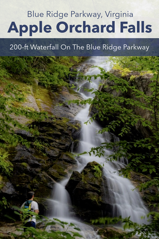
Apple Orchard Falls (200 ft)
What greets you at the basin of Apple Orchard Falls is unlike any part of the previous journey. A mostly dry ridge overtop gives way to a lush, wet, and densely planted cove that looks more like a tropical jungle than Southwestern Virginia. The tree canopy is so thick here that it partially obscure the top 1\3 of Apple Orchard Falls. One of the best parts of this waterfall is the series of bridges and viewing platforms positioned right below the main drop. Visitors can easily walk across the rushing streams of Apple Orchard Creek, from one end of the waterfall to the other, and settle down on one of several benches to enjoy the view.

The bottom half of Apple Orchard Falls 200 foot drop is split into two different waterfalls with the right half cascading down a massive boulder and rock pile. Hikers can cross to the opposite side of the stream via a wooden boardwalk to a sitting area and overlook platform.
From top to bottom, this awe inspiring waterfall is 200 feet tall. Near the 100-foot mark, part of the stream hits a series monolithic boulders leaning against the cliff, creating an entirely separate waterfall off to the right. When viewed from the left side, you get the classic “horsetail” shaped waterfall streaming straight down the side of the cliff. Despite its popularity, the strenuous 1,700-ft return trip of this hike means you might have very little to no company at the overlook. Enjoy your time here and soak in the moment for as long as you can.

From the overlook platform only the left side of Apple Orchard Falls is visible. Here you get the classic "horsetail" drop from the top of this 200 ft cliff. Only a handful of waterfalls this large exist in Virginia.
Up Next, we’re heading further south towards the Roanoke Valley to check out one of the earliest National Park Service Recreation Areas in the Southeast. Preserved as part of the Blue Ridge Parkway, the Peaks of Otter is one of the oldest and best preserved recreation sites in all of Virginia. Made up of Sharp Top, Flat Top, and Harkening Hill, these peaks were once thought to be the tallest in North America. Visitors to the area can summit the 3,875 ft peak of Sharp Top along a 2.9 mile trail to one of the best mountain overlooks in the Virginia. Stay tuned for this upcoming article and as always, see y’all on the trails!


0 comments