
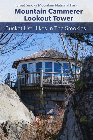
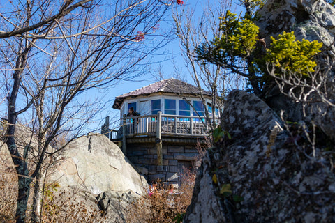
At 4,928’ ft, the lookout tower atop Mount Cammerer is one of the few remaining and accessible fire towers in the Great Smoky Mountains National Park. A bucket list destination for avid hikers, the most popular way to reach the tower is via the 11.2 mile Low Gap Trail. Beginning in the Cosby Campground, this 6 hour adventure entails 3,045 feet of elevation gain on what is considered one of the toughest day hikes in the Smoky Mountains. With panoramic views of the Pigeon River Gorge, the Mount Cammerer lookout tower was built in 1937 for the purpose of spotting wildfires in the newly opened national park.
Low Gap Trail to Mount Cammerer | 11.2 Miles Roundtrip
Low Gap Trail to Mount Cammerer Trail Map | Alltrails
Great Smoky Mountains National Park Trail Map
Low Gap Trailhead Location | Google Maps
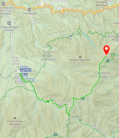
Approximate route of 11.2 mile Low Gap Trail to Mount Cammerer lookout tower via Gaia App.
Getting There
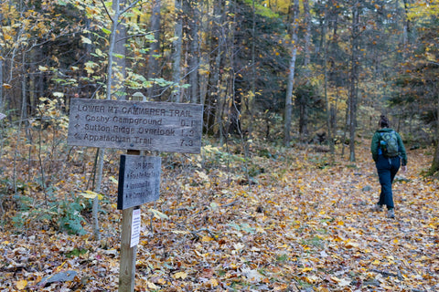
Named after the third director of the National Park Service, Arno Cammerer, the lookout tower atop Mount Cammerer is one of the most beloved and iconic landmarks in the Great Smoky Mountains National Park. Where once upon a time the Smokies had 10 operational fire towers, this is only one of three that remain. Over its 60 years as a manned fire tower, there have been a handful of routes created to reach its isolated location. The 13.5 mile Chestnut Branch Trail to Mount Cammerer is considered the longest and steepest with 3,582 feet of elevation gain. Parking on Mount Sterling Rd and hiking the Appalachian Trail from Davenport Gap to Mount Cammerer is the second longest at 12.25 miles. By far the shortest route with the least elevation gain, the 11.2 mile Low Gap Trail to Mount Cammerer has won out as the most popular route to take in recent years. The Low Gap Trailhead is located in the Cosby Campground just off Mount Sterling Rd. This is the largest and most developed campground on the eastern half of the national park and is actively managed by the Cosby Ranger Station. Driving down Cosby Entrance Rd, look for the Cosby Hiker Parking Lot just before entering the campground proper. There are two large lots here with restrooms, informational kiosks, and a picnic area.

Low Gap trailhead in front of the Cosby Hiker Lot.
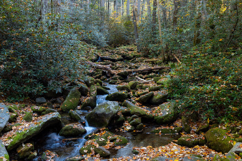
The first stretch of the Low Gap Trail is surrounded by beautiful cascades and thick forest in the vicinity of the Cosby Campground.
Low Gap Trail (2.9 Miles)
The Low Gap Trailhead is located right off the road in front of the Cosby Hiker Parking Lot (southeast corner). Throughout our journey, we will be transferring onto three different trails to reach the Mount Cammerer lookout tower. At 2.9 miles in length, the Low Gap Trail is by far the longest and toughest stretch. From the trailhead, the first 0.25 miles of this hike traverse a network of nature trails used to navigate the Cosby Campground. There are some very scenic spots with small cascades and a bridge crossing along the entire path as we follow Cosby Creek upstream to its headwaters near the Appalachian Trail.
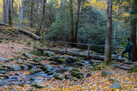
Bridge spanning Cosby Creek along the Low Gap Trail. This will be the only water crossing of the entire trip.
When you hit the Snake Den Ridge Trail junction make a left turn to stay on the Low Gap Trail.

Another set of scenic cascades as we travel up the Low Gap Trail to the Appalachian Trail.

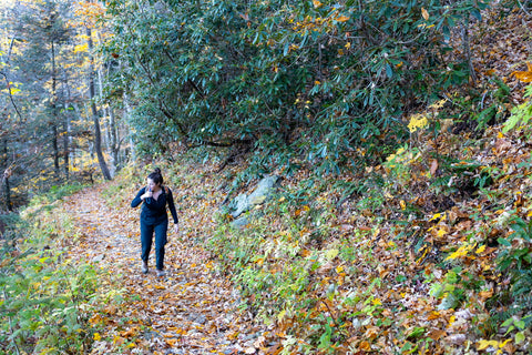
It looks pretty, but the trail here is deceptively hard with the path mostly made up of tree roots and rocks.
Throughout the 5.75 mile trip to Mount Cammerer we will be traversing three different trails with the 2.9 mile Low Gap section being the longest and toughest.
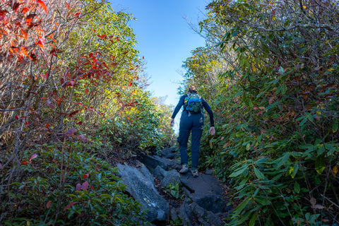
At the Snake Den Ridge Trail junction make a LEFT turn to stay on the Low Gap Trail. This is where the real challenge begins with a 2,045 ft climb straight up. While the incline is gradual at first, it quickly picks up steam as you double back on two major switchbacks carved out from the south slope of Rocky Face Mountain (4,650’ ft). If the steepness of the trail wasn’t difficult enough, the majority of this section is plagued with menacing tree roots and rocks which make each and every step a time consuming endeavor. While we were able to steamroll through this part on our way up, the trek back down was especially painful on our joints and feet.

Finally made it to the Appalachian Trail. The Low Gap Trail and Appalachian Trail junction rests on a physical landmark known as, “Low Gap”.
Appalachian Trail (2.1 Miles)
You’ll know you’re nearing the end of the hardest part of this journey when you can see sunlight piercing through the forest on the other side of a large meadow up ahead. The Low Gap Trail and Appalachian Trail junction rests on a physical landmark known as, “Low Gap”. This is a small saddle situated on a ridge line in between the summits of Ross Knob (5,083) and Sunup Knob (5,034). From this point we will be ditching the Low Gap Trail and taking a LEFT TURN onto the Appalachian Trail. Now on the world famous Appalachian Trail, we will be hiking 2.1 miles northeast to meet up with the Mount Cammerer Trail. While we are still technically going uphill, it is a little less than 1,000 feet of elevation gain and most of it will be aided by wooden steps.

The 2.1 mile Appalachian Trail section is the easiest smoothest part of the journey, but you’re still gradually climbing another 1,000 ft in elevation.
Unlike the hike up, this path is pretty well maintained, has a nice gradual grade, and remains much the same as when the C.C.C. built it in the 1930’s. What is today, probably one of the most popular sections of the entire Appalachian Trail, its path through the Smoky Mountains, almost never happened. An original path scouted by Roy Ozmer, on behalf of the Appalachian Trail Conference, had the trail bypassing the Smoky Mountains altogether and entering the area at Davenport Gap. Horace Kephart, an outdoor author and a strong advocate for a national park in the Smokies, convinced Ozmer to route the trail across the entire crest of the Great Smoky Mountains at the last minute before construction began.
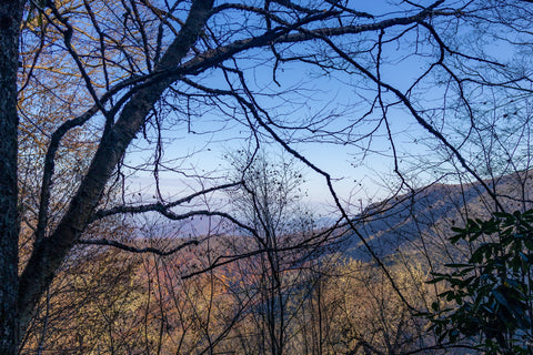
Views are lacking along this stretch, but occasionally you get a nice sneak peak of what’s to come from the lookout tower.
The majority of this route traverses over the heavily forested ridge tops of five major peaks of the Smoky Mountains. Occasionally you might reach a clearing with distant views of Green Mountain, the Foothills Parkway, and the large mountain chain just south of Newport. During late spring this is also the spot to see some blooming rhododendrons and mountain laurels. The north facing slope here only gets residual sunlight and is covered in dense colonies of ferns, mosses, and sedges. We chose a late October attempt in order to capitalize on seeing some of the best fall colors in the region. Once we cross onto the Cammerer Ridge, the Appalachian Trail reaches our last trail junction of this trip where it meets the Mount Cammerer Trail.
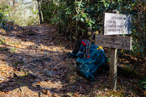
Reaching the final leg of the trip once we hit the Mount Cammerer Trail junction.
Mount Cammerer Trail (0.6 Miles)
Veering LEFT on this trail junction will transfer us directly onto the short 0.6 mile Mount Cammerer Spur Trail. This path leads directly over the Cammerer Ridge up to the summit and lookout tower. Out of the entire 11.2 mile journey, the time spent on the Mount Cammerer Trail is by far the most beautiful and picturesque. Open views stretching to the horizon on both sides of the trail and craggy outcroppings covered with huckleberry bushes line most of the route. Before reaching the lookout tower, the Mount Cammerer Trail descends a rough staircase onto a small protected cove known as Sharptop Gap. This is another small saddle surrounded by towering cliffs and boulders which is used as a tie-off for horses. Many people are not aware that large swaths of the Appalachian Trail may be traveled on horseback and some visitors opt to travel here using the bridal trails from the Big Creek Horse Camp.
The 0.6 mile Mount Cammerer Trail is the most beautiful and scenic part of this trip. After descending onto Sharptop Gap, we make one final scramble up to the tower.

Passing through dense stands of huckleberry, mountain Laurel, ash, and rhoalong this Smoky Mountain bald, you can spot the tower at the far end of the ridge.
Mount Cammerer Lookout Tower
Upon climbing back out of Sharptop Gap, we begin the last uphill scramble and exit out of the forest onto a typical Smoky Mountains bald with the lookout tower poking out of the hillside just 50 yards ahead. Squeezing through a tight channel between two slabs of the mountains summit, the trail abruptly ends at the foot of the tower. In 1934, the Civilian Conservation Corps built a camp at the base of the mountain and began constructing most of the trails and overlooks still in use today in the Cosby Area of the park. By 1937, the C.C.C. had made their way up to the summit of Mount Cammerer to begin construction of the two-story tower.
One final scramble and you’re home sweet home!

Before being renamed for Arno Cammerer, the mountain and lookout tower were known as the White Rock Lookout Tower.

In 1934, the Civilian Conservation Corps built a camp at the base of the mountain and began constructing most of the trails and overlooks still in use today in the Cosby Area of the park. By 1937, the C.C.C. had made their way up to the summit of Mount Cammerer to begin construction of the two-story tower.
The craftsmanship here can still be seen today. At its base the tower was built using hand quarried rocks from the mountain itself. Logs sawn from the surrounding forest were used for the second story cupola where rangers would spend their days looking over the Piegon River Gorge in search of wildfires. From the date of completion, it was actively manned by a fire ranger during the spring and fall fire seasons until the 1960s, after which it fell into disrepair before being restored in 1996 by the Friends of the Smokies. Before its renaming to honor Arno B. Cammerer, Mt. Cammerer was known as “Sharp Top” and “White Rock," referring to the bright white rocks that burst through the treeline at the summit. Upon completion of the tower it was even originally named “White Rock Lookout Tower”.
Logs sawn from the surrounding forest were used for this second story cupola where rangers would spend their days looking over the Piegon River Gorge in search of wildfires.
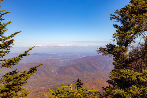
Looking north to the Foothills Parkway, English Mountain and the town of Newport.
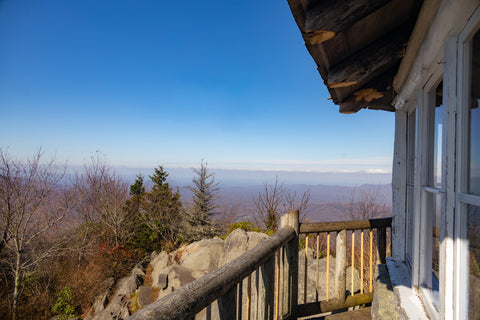
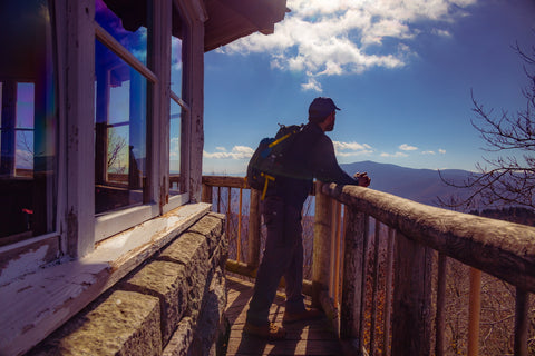
A few slab steps lead up to the rock face beside the tower where you can hop onto the covered deck. After walking around the octagonal cupola to soak in the views, you can even step inside of the retired quarters of where rangers once lived. Today, the tower sits empty, but members from the Appalachian Trail Conservancy make an annual pilgrimage here to spruce up the space and attend to any needed repairs. Though some people might be tempted to, the tower is off-limits for overnight camping. In order to help conserve this landmark for the continued enjoyment of everyone that visits, please make sure to pack out all trash and refrain from vandalizing the tower.
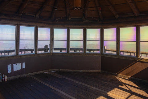
In the 60 years that this lookout was operational, rangers lived up here during the spring and fall fire seasons.
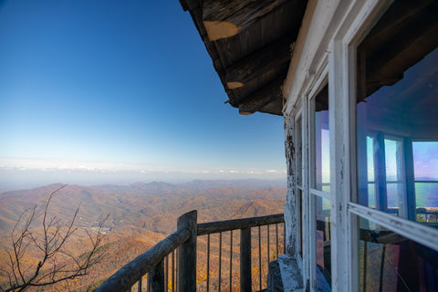
Looking south from the tower into North Carolina.
Another bucket list hike completed.
To finish up this hike, turn around and retrace your steps back to the Cosby Campground the same way you came up. Finishing up this bucket list hike makes going anywhere else in the park seem trivial, but alas…. we push forward. Up next, we will be taking a break from summiting mountain peaks to do some waterfall chasing in the Big Creek Area. Midnight Hole Falls and Mouse Creek Falls can easily be reached from an easy 2.25 mile hike on the Big Creek Trail. Situated in the most isolated section of the Great Smoky Mountains National Park, the Big Creek Ranger District contains one of the largest and most scenic mountain watersheds in the park. Stay tuned for this upcoming article and as always, see y’all on the trails!


0 comments