

Cherokee Arch Trail (UNOFFICIAL) | 1.8 Mile Out & Back
Cherokee Arch Trail Map | AllTrails
Chimney Top Rock Area Location | Google Maps
Before beginning, a word of CAUTION: Parts of this hike include UNMARKED TRAILS, not registered on any official map of Red River Gorge Geological Area. This hike includes scrambling over exposed cliffs and rock ledges that have resulted in deaths and injuries. Do not venture out alone. Use common sense and do not attempt anything that would put yourself or others at risk or harms way. This is NOT meant to be an instructional article, but a recollection of my own journey. The Red River Gorge is home to several species of venomous snakes as well as black bears. Be Bear Aware. Do your own research before going out and attempting any hike!
When it comes to UNOFFICIAL Trails in the Red River Gorge, the Cherokee Arch Trail is considered to be one of the “crème de la crème”. This well established user made trail in the Chimney Top Rock Area is packed full of scenery and when done entirely, travels to 8 off-trail arches and 2 distinct overlooks. One can find information on this trail all over the internet with maps and GPS coordinates, but some of it is inaccurate so it takes a great deal of research to attempt this hike. On this journey we opted to cut the trip in half by taking only the direct route to Cherokee Arch, leaving the additional 0.5 mile spur to Mushroom Arch, Hemnsath Arch, and Rat Windows 3 & 4 for another trip. If you have extra time while exploring the Cherokee Arch area, the same valley is also known to contain a handful more hidden arches within some of the larger caves below the cliff line, including Dragons Arch. Many of these UNOFFICIAL points of interest can be found on the kyarches.com database and similar websites.

Cherokee Arch Trail (1.8 Mile)
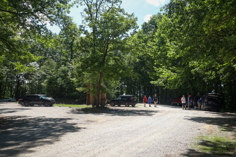
We began this journey by turning off of KY-715 and driving down Chimney Top Rock Rd until reaching the Chimney Top Rock Recreation Area. Though I typically prefer to off-trail hike during the colder seasons, Chimney Top Rock Rd closes during most of the winter, forcing visitors to hike in the 5-mile length of road just to reach the recreation area. The start of the Cherokee Arch Trail is marked by a path crossing in between two wood pillars to the far RIGHT of the Princess Arch Trail. There is no mistaking this trailhead once you see it. During the first stretch of this trail you’re hiking so close to the Princess Arch Trail that you can actually hear and see other people through the trees nearby.

Following this path we walked through two small campsites until reaching a third larger campsite at the far end of the ridge. At this point the trail seems to disappear, but actually continues on the LEFT\northwest corner of the campsite. It was hard to see at first since a downed tree lay in front of it. One of the downsides of attempting this trail during the warmer months is that it can become overgrown, making it difficult to discern where the paths truly are. In essence we are hiking parallel to the edge of the ridge until reaching the spot where we begin descending into the valley below near the Rat Windows. One of the most helpful tips on this route is to have the gps coordinates for Rat Windows #2 on your map so as to make sure you are headed in the right direction.

Rat Window #2 (-37.8308,-83.6123)
As you approach Rat Window #2 there is a very obvious split in the trail with the path on the LEFT headed towards Mushroom Arch and Rat Windows #3 & #4. You want to stay RIGHT at this intersection. Within a few feet of this split, the trail begins a slight descent with the cliff line rising high on your lefthand side. Near what looks like a dead end is where you’ll find Rat Window #2. This small hole that looks as if it were scratched out from the side of a ridge is nowhere near large enough to be considered an arch. Smaller openings called windows, generally located in the center mass of rock, are peppered all throughout the Red River Gorge and may someday even erode to become a full fledged arch. If you are standing facing Rat Window #2, the trail continues through a thicket of rhododendron directly behind you.

Gladie Creek Overlook
Squeezing through the brush and making our way down a set of ledges, we abruptly walk out onto an expansive overlook. Perched at the far end of a bald ridge, the wide open views from here are incredible and rival any of the popular overlooks in the area. The view straight ahead is that of the Gladie Creek Valley which is a main branch of the Red River and leads out to the Indian Staircase. Though out of sight, the Gladie Visitor Center is located at the bottom of the gorge below you. The rock outcroppings surrounding us are engulfed with wild blueberry and huckleberry bushes bursting with fruit. These are some of the tastiest snacks you can find in the wild. Causing us pause out of concern, we discovered large claw marks all over the ledges near the fruiting bushes appearing to belong to bears. Even out here we still have to be bear aware.

Rat Window #1 (-37.8304,-83.6119)
From the overlook, the trail continues to descend down a narrow series of switchbacks until we arrive at a wide ledge. At this point the trail completely disappears and you’re left standing at the precipice of a 15 foot cliff. DO NOT GO DOWN THIS WAY. This is the part that tricks people into quitting the hike. For a brief moment I pondered, “am I really supposed to scramble down the sheer cliff”…..”this can’t be the way, that’s way too dangerous, maybe I can pull it off, nah guess I’m turning back”. While taking another look at my GPS I noticed that I should be standing next to Rat Window #1. So facing away from the edge of the cliff I began tracing a rough path to my LEFT under the ridge I had just come down from and found the entrance to Rat Window #1.

You can see the top of the opening with some sunlight peering through behind a lot of deadfall and brush that must be navigated around as you walk downhill towards its entrance. It’s such an unfortunate name for what turns out to be such a cool looking arch. There is not much information out there on the size of this window, but by my estimate it is roughly 20 feet tall by 8 feet wide once you walk all the way inside of it. Appearing as a narrow, arching doorway, I’m assuming that this could have been a shallow cave at some point before the back wall caved in. Of all the Rat Windows, this is the largest, but Rat Window #3 (a.k.a. Alligator Window) might be the more fascinating to see.

Cherokee Arch (-37.8297,-83.6150)
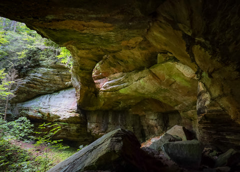
Rat Window #1 is the key to finding the correct path down to Cherokee Arch. Standing at the top of the hill looking down at the entrance to Rat Window #1, turn completely around. Facing the dense thicket of rhododendrons, look down and there should be a hidden trail obscured by the heavy foliage. This is the way down to the valley below. It took some trial and error, but after finding this path, we crawled under some downed trees blocking the way and scrambled over a steep ledge until finally reaching the valley floor. At this point, all it took was following the path to our RIGHT\headed west all the way to Cherokee Arch. On the way are a series of smaller cave openings containing little known arches like Dragons Arch, that are unique to the area. The sight of Cherokee Arch is unmistakable with its enormous cliff overhang and rockshelter.

On the approach, one can hear the water trickling over this arch which hosts a substantial 50 foot waterfall after a heavy rain. Cherokee Arch spans 40 feet over the opening of a 50 foot tall cave opening which rivals any rockshelter I’ve seen at the gorge to date. Forming a solid land bridge extending from the corners of the ridge and meeting in the middle, this arch reminds me a lot of Hopewell Arch, Ravine Arch in Yellow Birch Ravine Nature Preserve and Fern Bridge in Carter Caves State Park. To get a better look we traversed the massive rockfall inside the cave and scrambled up the sand embankment near the back wall to see the full scope of this beauty. Despite there being a solid path leading to this hidden gem, the area surrounding Cherokee Arch sees very few visitors. This is evident by the soft soil and lush vegetation present here, including the prolific blooms of fire pinks. In order to keep this area in good shape, stay on the established paths and try to avoid trampling the vegetation.
Up next, we’re headed south into the Volunteer State to explore some of the state parks and nature preserves surrounding the city of Nashville. The scenic landscapes of the Narrows of Harpeth, Short Springs Natural Area, Old Stone Fort, and Rutledge Falls draw in thousands of visitors each year looking to escape the hustle and bustle of Tennessees’ state capitol. Containing some of the more majestic waterfalls in the region, these areas are also awash in archeological curiosities that still puzzle scholars till this day. Stay tuned for these upcoming articles and as always, see y’all on the trails!


0 comments