

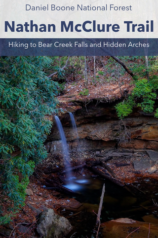
Known for its numerous caves and hidden underground passageways, Carter Caves State Resort Park is also home to a dazzling array of natural arches, including one of Kentuckys largest natural bridge. Interspersed throughout the 33 miles of trails are the impressive structures of Shangri La Arch, Smokey Bridge, Natural Bridge, Fern Bridge, Raven Bridge, and Cascade Bridge. This gem of the Kentucky Public Land system is located near the northern terminus of the Sheltowee Trace Trail on the outskirts of the Daniel Boone National Forest. As one of the states most visited parks, it hosts several annual events including the Crawl-o-thon, Pioneer Life Week, and the Winter Adventure Weekend. One can fill an entire day exploring the parks impressive geological formations and still not manage to see it all, which is why I’ve traveled here with the sole purpose of exploring its main arches.
Natural Bridge Loop | 0.5 Miles
Three Bridges Trail | 3.6 Miles
Raven Bridge Trail | 0.6 Miles
4 C’s Trail | 8.3 Miles
Box Canyon Trail | 0.8 Miles
Carter Caves State Resort Park Trail Map
Carter Caves State Resort Park Location | Google Maps
Cascade Caverns State Nature Preserve Location | Google Maps
Established in 1946, Carter Caves State Park is located in the foothills of the Appalachian Mountains, just shy of 40 miles from the West Virginia state line. This 2,000 acre park is made up of three distinct areas; the main property with Bat Cave State Nature Preserve carved into the center of it and the extension of Cascade Cavern State Nature Preserve located 2.5 miles away which offers a cave tour of Cascade Caverns. It is also adjoined by the 947 acre Tygart State Forest in the northwest corner, which is home to one of the states few master logging courses. While most people who venture into this park do so with plans to take one of the many ranger guided cave tours, I’ve sketched out an itinerary fully dedicated to exploring all of the parks arches.

Natural Bridge (Natural Bridge Loop)
Our journey begins by veering left off of Carter Caves Rd onto lc-8024A, which serves as the main entrance into Carter Caves State Park. Blazing a path through the scenic canyon of Cave Branch Creek, this road passes by several cliff overhangs, rock shelters, and wild cave openings including that of Laurel Cave, Horn Hollow Cave, and X Cave. According to historians, this road is one of the states original buffalo traces. Created by the now extinct woodland buffaloes traveling from the heavily wooded forests down to the watering hole of Tygarts Creek. Within that cluster of cave openings is a pair of documented arches named Copperhead Twin Arches, which unfortunately we won’t get a chance to see today. It’s one of the most gorgeous park entrances in the state with the potential to transform every outdoor enthusiast into a giddy little kid. Turning into the Visitors Center parking lot at the end of the drive, we head over to the first arch of the trip, Natural Bridge. The trailhead for Natural Bridge can be found behind the left hand corner of the building along a paved path.

Heading downhill from the Visitors Center, we walk past a large picnic pavilion near the entrance to Natural Bridge and an overflow parking lot with the official trailhead. The whole area is filled with interesting rock formations including small pocket caves and rock shelters worth exploring. Crossing the small wooden footbridge, we descend into the ravine that ends at the entrance to this arch. As we near the end of October, the trees in the area have just enough foliage left to lend some color to the stark landscape. To the right, above the sheer cliffs is Cave Road which runs over Natural Bridge. It’s the only arch of its kind in the state that supports a paved highway with regular traffic.

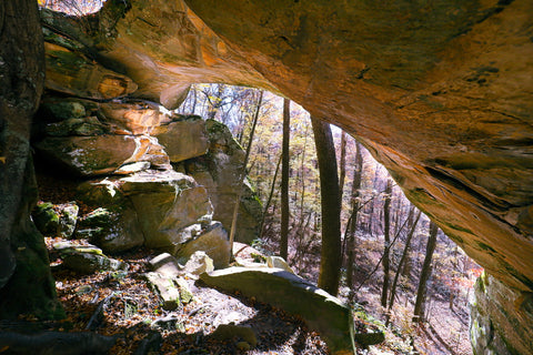
After a few short minutes, we can spot the darkening wide crevice that marks our destination. At 50 feet tall and with a span of 51 feet, this arch is monstrous. For all intended purposes, Natural Bridge started its life as a cave which was slowly eroded by the currents of Cave Branch Creek into a 300 foot long tunnel, much like Natural Tunnel State Park in Virginia. The creek itself flows through this arch and disappears under the hillside next to the Visitors Center, before reemerging near the entrance to Laurel Cave. Geologists believe that at one point all of the caves in the center of the park may have been connected with Natural Bridge being an extended passageway. The theory supposes that cave-ins throughout the complex over a period of millions of years left them stranded as the individual entities we find today.

Looking up right inside the mouth of this arch is a window peering out at the hillside above our heads. This small skylight 50 feet above is in fact a documented arch named Arch Ky-8. During heavy downpours, a small waterfall can be seen streaming down through this opening into the cave. Tucked into a small corner right below this is a shallow opening that’s actively being eroded into a narrow tunnel that might someday bust through to create another archway. Following the bend through the heart of Natural Bridge, we exit out the back end into the forest. Look across Cave Branch Creek and spot the large rock shelter carved into the north wall of the arch. Another documented arch, Bat Cave Arch, is located near the entrance to Bat Cave just a hundred yards upstream from here. The trail continues through the woods just behind the back entrance and loops uphill onto the highway above.

Smoky Bridge (Three Bridges Trail)
Next on our list of arches is Smoky Bridge. This arch along with Raven Bridge and Fern Bridge can be seen along the scenic 3.6 mile Three Bridges Trail which loops around the main section of Carter Caves State Park. While this would make for an extraordinary day hike, it wouldn’t leave much time to see all of the other arches. On this occasion we will be utilizing several connector trails as shortcuts conveniently located throughout this expansive loop. To reach Smoky Bridge, we get in our car and drive over Natural Bridge, turning left at the intersection in the direction of the lodge. This drive has us ascending onto the ridges above the visitors center which offers a birds eye view of the whole area. At the four way intersection, which can be a bit confusing, continue straight while merging onto Caveland Drive. Pretty soon the sloping roof line of the mid century modern Lewis Caveland Lodge will come into view on the right. John F. Lewis owned much of the land making up Carter Caves. Beginning some of the first documented cave tours here, he eventually became one of the earliest proponents of conserving and consolidating all of the caves into one main attraction.

Parking in the large lot beside the lodge, I walk in the direction of the far left of the building, past the main entrance, to reach a connector to the Three Bridges Trail. This trailhead is a main junction that splits off to the Raven Bridge and Rockhouse Trails, which we will be returning to later on. Taking a RIGHT at this intersection, we head south roughly 0.25 miles towards the ravine containing Smoky Bridge. The first clue we get to the location of the arch is the small wooden overlook positioned at the edge of a sheer cliff. Climbing onto it, I’m left a little dumbfounded by a lack of anything interesting to see down below. Thats because for one weekend out of the year, during Winter Adventure Weekend, a zip line is stretched over the canyon from this spot for adrenaline junkies to repel across. It’s not until we round the bend on the trail and turn RIGHT onto the descending staircase that I realize we were standing directly over the 40 foot span of Smoky Bridge.

What Natural Bridge poses in length, Smoky Bridge turns it on its heads with its height. The narrow shape of this arch accentuates its height and rounded openings to appear as if you we’re inside the great room of a Middle Age cathedral. In terms of volume, this is one of the largest natural bridges in the state, right behind Creelsboro Natural Bridge. If you look closely at the rounded dome within Smoky Bridge, it has the identical shape and weathering as the rotunda room in Mammoth Cave National Park. This pattern is caused by swirling water, which has eroded large slabs of limestone to fall, creating the breakout dome we see today. To the left of the main entrance, just up the hill is a small cave opening that reaches a dozen feet into the cliff. A dry creek bed runs the length of this ravine, through the heart of Smoky Bridge alluding to how it was created. But, without water underneath it at the moment, how can it be considered a “bridge” instead of an “arch”?

During heavy downpours, the entire surrounding ridge feeds a seasonal stream that works its way into the arch, creating a large natural pool in the center of it. Walking through to the back end of the structure, we get the typical sloping amphitheater shape that most large rock shelters are known for. In the center of it, the last remnants of a previous rain storm drips in a steady stream that’s considered a photo worthy waterfall when its at full flow. The best view here is from atop one of the large slabs of rock protruding out of the sloping hill. Smoky Bridge may be the largest in Carter Caves State Park, but the rest of the arches on our trip are just as fascinating in their own way.

Raven Bridge (Raven Bridge Trail\Three Bridges Trail)
Leaving Smoky Bridge, we head back up the hill towards the Lewis Caveland Lodge in search of Raven Bridge. After the 0.25 mile hike, turn LEFT at the Three Bridges Trail junction to reach the road looping in front of the lodge. Here you’ll find the Raven Bridge Trail. At 0.65 miles long, this trail travels along the ridge above Raven Bridge and descends a staircase tucked into a narrow crevice behind the arch. Alternatively, one could still reach it by continuing along the Three Bridges Trail heading north from Smoky Bridge. This route maneuvers through the often muddy lowland areas bordering Smoky Valley Lakes. Taking this route, if you’re not vigilantly on the lookout for the Raven Bridge Trail connector, you can easily hike right past it. This trail is mostly flat with the exception of a few dips in and out of shallow creek beds, aided by some sturdy wooden bridges.

A third of the way through is the junction for 0.14 mile Rockhouse Trail. A little visited spur, Rockhouse Trail cuts down through a narrow ravine, before entering a hidden canyon containing a towering cliff overhang. Seeing the larger than life structure, with all of the tall slabs of limestone scattered about reminds me of the archeological sites surrounding Hemlock Cliffs. Archeological studies conducted within the grounds of Carter Cave State Park, have yielded evidence that the area was inhabited by people going back to the Adena Culture during the Early Woodland Period. Just a ridge over on the banks of Tygart Creek, a 23-year study conducted at the Three Slipper Shelter, one of several containing evidence of prehistoric occupation dating back to 800 B.C. is the best documented in Carter County. Digs at the site unearthed burial pits containing three well preserved slippers made of plant fibers that are now on display at the Webb Museum of Anthropology at the University of Kentucky. A griddle stone was also unearthed here, giving insight into how prehistoric people developed simple technologies.

The Ravens Bridge Trail ends abruptly right in front of the arch itself. From this vantage point at the very top of the 20 foot high arch, one gets a clear view of what appears to be a ravens head facing to the right. If I hadn’t seen this arch for myself, I would have never believed just how much like a bird it really looks like. A ring of light grey lichens, which is naturally occurring, forms an eye right where the head of the raven juts out to form a beak. On a side note, if you were to highlight the Ravens Bridge Trail as it connects down to the Three Bridges Trail, it creates the image of a birds head. Pretty freaky, right?! A staircase built into a narrow chute behind Ravens Bridge, guides hikers down to the valley below.
Here we get the full frontal view of the 30 foot span of the arch. Inside of the arch, near the very top of it is a spacious rock shelter. While at first I foolishly tried to scale the hillside dead on to reach it, I eventually discovered an easier path. Following the bottom of the cliff coming in from the right side of the arch, I found a well traveled path that leads up to it. Squeezing in between and scrambling over boulders, I reached the very top of this hidden perch. Though it doesn’t provide great cover from the elements, this elevated position offers a fantastic view of the valley below. Coincidentally, the concave shape of the arch ceiling draws in distant sounds and echoes them to those sitting inside. I was able to hear the muffled sounds of distant conversations and footsteps, well before I ever even saw anyone approaching.

Fern Bridge (Three Bridges Trail)
From Raven Bridge, it’s nearly another 1.25 miles to reach Fern Bridge headed north along the Three Bridges Trail. If you were to hike there and then retrace your steps back to the lodge, it would put you at a little over 3 miles. A more convenient way to reach it if you’re in a time crunch is to follow Caveland Drive to the four way intersection and take a sharp right turn towards the group cabins. In the center of the complex is a playground with a parking lot where one can leave their vehicle. On the north end of the playground, tucked between two cabins, is a trailhead leading downhill to the climbing and rappelling area, which merges into the Three Bridges Trail. From here its a much quicker 0.75 miles to Fern Bridge.

This section of the Three Bridges Trail maneuvers over several sheer cliff lines with panoramic views of the parks entrance along Cave Branch. Central to what makes Carter Caves so unique is the porous bedrock of limestone and sandstone below the surface which is responsible for creating its famous formations. Sandstone in particular is typically soft, fragile, and easily eroded into vertical joints and cracks. Its great friction qualities form excellent terrain for rock climbing which is why in 2015, Carter Caves became the first state park in Kentucky to dedicate an entire area for rock climbing and rappelling. Already a tremendously popular sport 60 miles south of here in Red River Gorge, the park offers workshops and courses for beginners looking to get out on the cliffs for the first time.

Speaking of cracks, the Three Bridges Trail begins its descent in the cove containing Fern Bridge by squeezing through a narrow slit, reminiscent of the Needle Eye stairway in Natural Bridge State Park. It appears once you hit a dead end where the trail abruptly turns LEFT at an orange blazed trail marker. The trail is steep here, despite the rock slab steps guiding the way. As soon as you hike through this area and turn right, Fern Bridge will appear straight ahead against the cliff face. If you can’t see the arch, just turn your gaze upwards at the long crack in the ceiling. At 110 feet high, it is currently classified as the tallest natural bridge in Kentucky. Spanning 45 feet across, it was carved by a wet weather creek flowing from the ridge above, which happens to form a spectacular waterfall immediately after a heavy downpour. Though just a barely noticeable trickle today, its enough to get splashed by as you walk across the bridge directly below it. Once you’re done exploring this arch, retrace your steps back to the playground parking lot.

Shangra La Bridge (4C’s Trail)
Shangra La Bridge is one of the most interactive arches in the park and the one I had the most fun exploring. To reach it, drive out of the group cabin area along Caveland Drive and at the four way intersection take the road that’s slightly left of the fork to merge onto Lodge Road. Continue straight, following the signs for the boat ramp, which will have you turn RIGHT onto a one lane road, descending down a narrow ravine. One of the least exciting parts of this whole trip was having to back my way out of this road when I came face to face with an incoming truck headed my way. Just shy of reaching the boat ramp, our destination will be a gravel pull-off with the 4C’s Trail Connector appearing on the RIGHT. From the trailhead, Shangra La Arch is an easy 0.25 mile stroll.

Smoky Valley Lake is looking pristine on this fall evening. Even with boats on the water, it is so quiet that one could hear a pin drop, as this lake only allows electric powered motorboats. One of the first areas of Carter County to be settled in the early 1800’s is just several miles upstream from this lake in Smoky Valley. The 8.3 mile 4C’s Trail, which stands for Carter Caves Cross Country, is one of the parks longest. It crosses two suspension bridges, ducks under several large rock shelters, and descends directly into the natural tunnel of Shangra La Bridge. Directly across on the opposite banks of the lake is the Johnson Backcountry Campsite situated near one of the parks largest rock houses. A little past that near the swinging bridge is another hidden arch named the 4C’s Arch. . Once approaching the 4C’s Trail intersection from where you parked, turn RIGHT.

This section of the trail traverses through a boulder field directly underneath a cliff overhang that collapsed some thousands of years prior. Neon orange arrows, spray painted over the rocks, guides hikers in the right direction. The trail suddenly disappears at the edge of a ravine with a sheer drop on one side and the entrance of a cave tunnel on the other. This mysterious tunnel is the entrance to Shangra La Arch. Getting inside of the arch requires a scramble over several boulders as there is no dirt trail here. Shangra La Arch was created by a sinkhole collapse. Filled with water by a wet weather stream, it was eventually carved into a 50 foot long tunnel, with another exit hole punched out of the side of this cliff. As a whole, the structure is only 7 feet wide at its tallest point and roughly 8 feet across.

The term “Shangra La”, or “Shangri La” as its commonly spelled, was coined by English author James Hilton in his 1933 novel “Lost Horizon”. Since then, Shangri-La has become a term used to describe an imagined earthly paradise, with inhabitants that are almost immortal, living hundreds of years beyond the normal lifespan, and only slowly aging in appearance. James Hilton was inspired by reading ancient Tibetan scriptures which eluded to the hidden existence of seven such places, created in the 9th century as idyllic, sacred places of refuge for Buddhists during times of strife. As the shape of the tunnel curves sharply, it manages to hide a view of the exit as you walk through, creating an air of mystique around it. Soon, light peers in from the large skylight in the cave ceiling, where a wooden ladder extends to the surface, allowing us to exit. During periods of heavy rain a waterfall forms here. Flowing through the tunnel and exiting out the way we entered, it forms what’s known as Shangra La Falls.

Cascade Bridge (Box Canyon Trail)
Retracing the 4C’s Trail back to our car, we head out to hunt our last arch of the day as the sun begins to set. Cascade Bridge is located midway along the Box Canyon Trail, within the grounds of the Cascade Caverns Nature Preserve. Any gps will take you there, but if you prefer written directions, the visitors center offers a step by step guide for how to reach it. At 2.3 miles away, it roughly takes 8 minutes to reach from Carter Caves main entrance. This trailhead is located across from the entrance to Cascade Cave and explores the canyon opposite the cave system. Most of the land encompassing the nature preserve was set aside for preservation to protect its rare population of mountain maple and Canada yew. Both of these species, though normally found hundreds of miles farther north, thrive in the cool and moist air of the box canyons surrounding Cascade Cave. After our hike, we’ll be returning to this spot, just in time to catch a ranger guided tour of Cascade Cave, which also happens to contain a hidden natural arch.

At 0.8 miles long, the Box Canyon Trail splits off into a loop after the initial walk in. If you look at the trail on a map, its route resembles the shape of a lasso. It is meant to be hiked counter-clockwise by turning RIGHT at the intersection. With Cascade Bridge being located near the center of the trail, there is really no advantage or disadvantage to taking either route. Walking uphill the first 50 yards, we encountered the entrance into the box canyon via fat mans squeeze. Descending through a narrow crevice between two cliffs, we duck down under a ledge to emerge at a sheer cliff looking down into a heavily wooded ravine. A stone staircase built into the mountainside guides hikers down onto the trail which spends most of its duration tracing the rim of this cliff. This place feels so hidden and secluded, it bogles the mind as to how anyone found it.

There are two large rock shelters here, side by side, that reside under what appears to have been an enormous cliff overhang. At some point in prehistory, this formation collapsed into the boulder field littering the trail before us. Remnants of an earlier rainfall are still trickling in front of both shelters, alluding to what might be some amazing wet weather waterfalls. After exploring both of these areas, we climbed the hill out of the canyon and stepped right in front of Cascade Bridge. From the direction we came in, the arch is angling away from us tucked into the side of the cliff. From our direction one can easily make out the legs of the arch, with a thin gap outlining the structure on the far right.

At 30 feet high and spanning 40 feet, Cascade Bridge may not be the biggest arch in Carter Caves, but its unique setting helps it stand out amongst its peers. Looking at Cascade Bridge while standing in front of it, the formation looks more like the stage of an auditorium than anything else with its flat back. Geologists believe Cascade Bridge is what remains of an ancient cave that has since collapsed, with some of these boulders being all that's left of its former roof. Several stacked boulders adorn the very center of it near the opening above. A slender gap, not much more than a foot wide at its center by 10 feet long, separates the cliff from the arch. Even a seasoned arch hunter as myself had trouble recognizing what credentials this rock formation had to be classified a bridge until I could clearly make out the gaps. It’s assumed that at some point, water from the ridge above flows down through the crack creating a thin waterfall during a heavy downpour.

While the arches mentioned above are all of the main formations advertised in Carter Caves State Park, there are plenty more that are just off the beaten track. Arches and natural bridges are being discovered all throughout Kentucky on a daily basis and its not long before more of them receive their own trail in this park. Up next, I’ll be walking back to the parking lot to queue up for a ranger led tour of Cascade Caverns which consists of two separate caves and a bonus third cave containing Cascade Falls. There is also a hidden natural arch, Cascade Caverns Bridge, which is located in one of the underground passageways that tours regularly walk past. Stay tuned for details of this fun tour and until next time, see y’all on the trails!


2 comments
Our seniors are coming to Eastern Ky. in Sept. I don’t think anyone has visited this park. The bad part of this is some can’t walk very far. Please get back with me on some short trails and things to do . Thanks
Our seniors are coming to Eastern Ky. in Sept. I don’t think anyone has visited this park. The bad part of this is some can’t walk very far. Please get back with me on some short trails and things to do . Thanks