
Nathan McClure Trail 122A Trailhead
to Bear Creek Falls | 7.50 Miles Out & Back
Bear Creek Falls Trail Map | AllTrails
Bear Creek Falls Trailhead Location | Google Maps
There is ZERO middle ground when it comes to the Nathan McClure Trail. Hikers either love the challenge and are inspired by the raw beauty of the area OR they absolutely hated it, could not find it, gave up half way, or thought the waterfall was not worth it. I happen to personally think it was a mix of both in my experience. Though this is a mixed used trail shared with horseback riders, I found it to be in relatively good shape with minor erosion. Part of whats keeping this trail together is the fact that it is incredibly rocky. Ankle twisting stones lay everywhere, especially under dense layers of leaves just waiting to trip you up. Signage is adequate, but it could be better. Despite thinking highly of my navigational skills, I also made some wrong turns and got lost for a short period of time. Yes this trail is difficult and rugged AND you will probably get lost, but I kept getting sucked in to finish this hike by the promise of seeing one of the more unique natural bridge arches in the area, plus one of the few year round waterfalls still flowing during a severe statewide drought.

Nathan McClure Arch (-36.96404,-84.35451)
The trailhead for the Bear Creek Falls Trail is found almost exactly halfway along the Nathan McClure Trail between Little Lick Campground and Hindsfield Ridge Rd (Forest Service Rd 5068) near the end of Forest Service Rd 122A. To find it we drove down KY 192 just north of the Mt Victory Fire Department and turned south on Old Whitney Rd. This gravel backcountry road twists and turns through some rural farmland before abruptly entering the Daniel Boone National Forest where it becomes Forest Service Rd 122A. This is a part of the forest that has seen a lot of rehabilitation in the form of clearing and logging in the last several years which is noticeable as you drive through it. Finding the exact trailhead opening is tough while driving in, so the best way to do it is by heading to the turn around point at the end of Forest Service Rd 122A and working your way backwards. As it so happens, this entire road is filled with some of the most impressive natural arches in the area. With two easy to find hidden arches located a few steps from this turn-around point, we decided to take a few extra moments to seek them out.

Nathan McClure Arch
At the far right hand side of the turn around you’ll find a fairly large opening in the woods with a well trodden trail heading downhill towards Nathan McClure Arch. This is actually part of the Nathan McClure Trail and the turnaround itself is the halfway mark where horseback riders have a chance to either turn around and head back to Little Lick Campground or have a trailer waiting for them here to pack up the horses for the day. Walking downhill, it is a fairly easy 50 yard trek to the large clearing were Nathan McClure Arch juts out from the ridge on your left hand side facing the Rockcastle River. From our approach it is nearly impossible to see it so we actually walked over the top of it wondering where it could be. After a few moments and a howling gust of wind vibrating the ledge underneath us, we realized that we must be standing on top of it. Coming up from Little Lick Campground the arch rises up right in front of you, but from the opposite direction the top of the arch looks like it’s just part of the trail.

In-Out-Flat Arch (view from inside)
In-Out Flat Arch (-36.96629,-84.35357)
At 6 feet high and 12 feet wide, it has a near perfect circular opening and one of the more photogenic shapes of any arch out there. If you step into the small shelter underneath and look at it from the opposite side you’ll be able to make out two small skylights on the ceiling. Retracing our steps back up the hill to our car, we walked straight ahead to the opposite side of the turn around to find what looks like a small deer path heading into the woods. Making our way to the right of a sheer drop, we scootched down the steep hillside to find a wide mouthed cave shelter with our next arch carved out of the far right hand corner of the bluffs. In-Out Flat Arch is named as a comical nod to the fact that you have to lay down flat to be able to slide your body in and out of the formation. With a thick pillar that appears to be holding up the entire corner of the cliffs above, once inside the space opens up into a small cave shelter perched 10 feet above the forest floor.

Look for this trailhead near the end of FS Rd 122A
Bear Creek Falls Trailhead
After doing a little exploration, we got back in the car in search of the Bear Creek Falls Trailhead. From the turn around point at the end of Forest Service Rd 122A, its roughly 1.25 mile drive to a large mowed gap in the woods back in the direction we originally came. Looking over towards the RIGHT, we spotted the clearing marked by a brown metal stake with hiking and horseback riding emblems. Google Maps has this trailhead registered, but it is not accurate and will bring you within 20 yards of the correct spot. There is enough space here for two or three cars to park on the shoulder, but do not block the road as this is technically all part of the Nathan McClure Trail.

Towering rockshelter near start of trail
Scenic Valley of Pole Bridge Branch
From here to Bear Creek Falls is just shy of 3.75 miles one way making this a 7.50 mile out and back day hike. Though times can vary greatly, most people complete this in a little over 3 hours. This trail starts off by ascending to the top of a sparsely vegetated ridge before hitting a series of switchbacks that immediately take you on a straight shot to the banks above the Rockcastle River. In total this hike will contain nearly 1,000 feet of elevation change. At the very beginning there is not much to look at which is the last thing you want on a long and strenuous trail. Near a third of the way down, the scenery promptly explodes as we entered the densely forested valley of Pole Bridge Branch. The rhododendron is thick in these parts and crowds every bit of exposed dirt. Massive blocks of sandstone that were once part of the cliffs now line the bottom of the creek bank creating a network of chutes and cascades that make this a prime waterfalling location.

Nathan McClure foot bridge
One of the first major landmarks to catch our eyes and allude to the scenery that’s to come is a towering rock shelter at the bottom of a 100 ft tall cliff. The trail passes right underneath it before entering a dense tunnel of rhododendron. Emerging from the other side of the thicket, we lay our sights on the gorgeous Nathan McClure Bridge. Built to withstand heavy traffic from the horseback riders that frequent this trail, the bridge spans over a wide berth of Pole Bridge Branch as it cascades down into a seasonal waterfall known as Pole Bridge Branch Falls. At this point, you have descended nearly 400 feet down the valley and are 0.25 mile away from reaching the Rockcastle River. The views of all the surrounding cliffs really start to open as you reach a sharp left turn heading north that will lead us on a path running parallel to the river for the remainder of the hike.

View of Pole Bridge Branch emptying into Rockcastle River
History of Nathan McClure Trail
Despite all of the beautiful scenery, it is hard to imagine why anyone thought to build a trail in such a rugged and unforgiving place. The answer takes us all the way back to the expeditions of Thomas Walker, Daniel Boone, and the creation of the Northwest Territory. In 1750, Dr. Thomas Walker and his companions became the first known Europeans to discover the gap in the Appalachian Mountains which allowed a quicker access point to reach present day Kentucky from the wilderness frontier of Virginia and North Carolina. Nearly 25 years later in 1775, Daniel Boone and 30 other axe wielding road cutters set out to build the Wilderness Road across the Cumberland Gap. This trail would serve as the pathway to the western United States for some 300,000 settlers during the next 35 years. Following the defeat of the British during the War of American Independence in 1783, Congress formally took control of all remaining British land claims northwest of the Ohio River and created The Northwest Territory.

Rockcastle River at historic low levels during drought
Consisting of present day Ohio, Indiana, Illinois, Michigan, Wisconsin, and portions of Minnesota, this became one of the first major land grabs in American history. Eager settlers, pioneers, and speculators from the original 13 states dashed across the Cumberland Gap to make their land claims. On May of 1788, Lieutenant Nathan McClure and a small patrol were assigned to escort a group of settlers from the Cumberland Gap who were heading west into Kentucky. Lt. McClure and the small party of settlers, who were camped near Crab Orchard, were intercepted by Native Americans. To protect their land from encroachment, the Native Americans took the settlers’ horses and livestock. Nathan McClure left the settlers there that night to chase after the horses and livestock. They traveled through what is now Pulaski County to the Mount Victory area, where they caught up with the Native Americans. Lt. McClure was mortally wounded in the ensuing skirmish. His grave and tombstone are located near the turn around point on Forest Service Rd 122A.

Hidden cove of Nathan McClure Arch 2
Nathan McClure Arch 2 & Falls (-36.97449,-84.34899)
Most of our journey will consist of walking the lower bluffs of a 1,200 ft high ridge named Gulf Ridge. If you look over a topographic map, the southern half of the ridge tapers to a point and looks like a massive arrowhead. As we round past the tip of the arrowhead, the northern edge of this ridge line has a handful of secluded coves tucked back away from the trail. These hidden oasis’ are full of small cave shelters, seasonal waterfalls, and in this case a secret off-trail arch. In the second to last cove the trail passes by before descending the cliffs, you should be able to spot the Nathan McClure Arch 2. Spanning across two adjoining cliffs, this arch is in the far back corner of the cove above a small rock shelter.

Close up view of Nathan McClure Arch 2
There is a faint path that juts LEFT from the main trail towards the arch along the base of the cliffs. Ducking under and passing through the rock shelter, you emerge directly underneath a light trickling stream emanating from this waterfall arch. Perched nearly 20 feet high, this wet weather natural bridge has a seasonal stream flowing through it. There is a very long and narrow ridge at the top of a steep hill that leads to a hidden chamber underneath the arch, but the path is treacherous. Another way to see this arch up close would be to drive to the far end of Forest Service Rd Gulf Ridge 5141 and try to approach it from above.

Follow the white diamond blazes
The Turn Everyone Misses! (-36.97828,—84.34896)
After viewing the arch, hop back on the main trail heading north for another 0.30 miles to reach the dreaded RIGHT TURN. This is the trail junction that gets everyone lost and yes it even got me despite the fact that I knew about it. Though most of this trail is sufficiently marked by white diamond blazes, this turn is not. As you begin the steep descent down closer to the banks of the Rockcastle River, you’ll approach what looks like an old forest service road running left to right at the bottom of your first downhill stretch. It is hard to see, but if you look closely at the large tree at this intersection, it has some faint arrows spray painted white on them. At the sight of this, I figured I was supposed to keep left and continue forward. WRONG.

The dreaded “right turn” (turn right after walking down this hill)
The correct move here is to turn RIGHT and head downhill onto another series of switchbacks. Instead, I made the common mistake of taking a left and after about a 20 yard walk I hit a large downed tree with a path chainsawed through the middle…. which made it seem like the correct path. Another few feet forward and the trail almost completely disappears beneath some heavy vegetation. This is what made my spidey-sense go off. I had missed the RIGHT TURN. Walking back to the spray painted tree, I took what should have been a right turn down to another series of switchbacks that total 150 ft in elevation change. From here it is a straight shot to Bear Creek Falls roughly 1.25 miles away.

Bear Creek Falls Overlook
Bear Creek Falls (-36.991464,-84.355644)
The final home stretch to Bear Creek Falls is a respite from all of the previous hill climbs and descents of the first two-thirds of this trail. Mostly flat, our path weaves in and out of a handful of remote ravines on the east side of Gulf Ridge. With the Rockcastle River being only a stones throw away, we can really get a close up view of how devastating this years drought has been in the region. Rivalring portions of the Cumberland Rivers depth and girth, at current levels the Rockcastle River is only a third of its normal height. Truth is, states all across the Mississippi River basin are experiencing drought more commonly found in the arid Southwest. Most of Kentucky is seeing abnormal dryness, with the western side of the state seeing the most severe effects. The Rockcastle River is one of Kentuckys best whitewater streams with Class II, III, & IV rapids. The section that flows adjacent to the Nathan McClure Trail is also designated a Kentucky Wild River for its raw and untouched beauty.

Normally this area is 5 ft below water
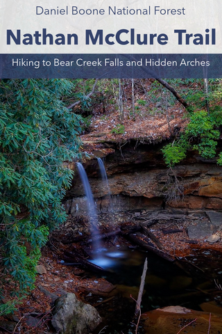
The Rockcastle River gets its name from Isaac Lindsey, an explorer who viewed the rock formations along the water in 1767 and thought they resembled castles. Up ahead we can see the confluence of where Bear Creek empties into the larger river at the southernmost section of an area known as The Narrows. The waterfall we’ve trekked nearly 3.50 miles to see is located another 0.25 miles upstream from here. As the trail turns inward to follow Bear Creek, we lose sight of the sun behind the cliffs and densely shaded stands of rhododendron and pine to enter a particularly beautiful portion of the Daniel Boone National Forest. There are a handful of dispersed campsites with fire rings here that backpackers can use. The most prominent of the sites sits on a ledge overlooking the 22 ft high Bear Creek Falls.

Close up of Bear Creek Falls
From our approach, the prominent sound of crashing water was a welcome relief as it was a 50\50 shot wether this waterfall would be running or not. Looking down into the small gorge created by the falls we can make out several smaller cascades that are normally under 5 ft of water when this creek swells up. At the top, Bear Creek Falls is split into two separate spouts giving it a unique look. The Nathan McClure Trail continues over the top of the falls and climbs a nearby ridge where an old logging road extends 2.2 miles back to Forest Service Rd 122A. This drops you off a further 2 miles behind the trailhead where we parked so I wouldn’t recommend taking this way back. To get a closer look at Bear Creek Falls, we found a tight scramble down into the waterfall basin behind one of the campsites.

One of the more dependable year round waterfalls
There is another known, yet undocumented smaller waterfall on the northern bank of the basin that could be photogenic with some more flow. We found some great vantage points down here for a small photo shoot worthy of todays 7.50 mile day hike. To get out of here, we simply retraced our steps back the way we came and this time took a sharp LEFT TURN at the dreaded right turn intersection. Even though it took 2.5 hours to make the hike to Bear Creek Falls, the clocked the return hike right at 1 hour long. Up next, well be continuing our Fall\Winter series of arch hunting trips in the London District of the Daniel Boone National Forest. Stay tuned for our upcoming series of videos as we explore some of the hidden gems of the Kentucky wildlands. As always, see y’all on the trails.


0 comments