

The Cloud Splitter to Indian Staircase Loop in Red River Gorge is a bucket list hike every experienced hiker aches to cross off their bucket list. At nearly 9 miles long, this epic day hike travels through some of the Sheltowee Trace Trails best known landmarks within the gorge including; Cloud Splitter, Sheltowee Twin Windows, Indian Arch, Adena Arch, Council Chamber Rockshelter, Shawnee Arch, and Indian Staircase. Parts of this adventure traverse some of the hidden network of unofficial trails that criss cross the Red River Gorge not found on most maps. It goes without saying that portions of this trail are inherently dangerous and involve some calculated risks, but can be very rewarding for those who take the appropriate precautions.
Cloud Splitter to Indian Staircase | 9 Mile Loop
Cloud Splitter to Indian Staircase Trail Map | Alltrails
Cloud Splitter Shortcut Trailhead Location | Google Maps
Red River Gorge Location | Google Maps
Red River Gorge Trail Map | Daniel Boone National Forest
At nearly 9 miles long and with over a combined 700 feet of ascent and descent, this is not a spur of the moment kind of hike. Nearly half of this trek involves navigating some of the unofficial trails in the area which can become confusing to follow at times, especially for those who lack experience with backcountry hiking. Adding to the drama are the dangerous rock scrambles to summit both Cloud Splitter and Indian Staircase. With that in mind comes a note of CAUTION: This is an unmarked trail, not registered on any official map of Red River Gorge Geological Area. This hike includes scrambling over exposed cliffs and rock ledges that have resulted in deaths and injuries. Do not venture out alone. Use common sense and do not attempt anything that would put yourself or others at risk. This is NOT meant to be an instructional article, but a recollection of my own journey. Portions of this hike are NOT suitable for small children. Do your own research before going out and attempting this hike.

Cloud Splitter
Despite having visited some of these sites sporadically throughout the years, this was my first time undertaking the entire length of the Cloud Splitter to Indian Staircase Loop in one go. For full disclosure, I don’t do well with heights. While the climb up Cloud Splitter was manageable with the ropes provided at the site, the descent down sent chills up my spine. For that reason I decided not to climb up Indian Staircase, but instead hiked the route to the top of it and retraced my steps back to complete the loop. Despite skipping the ascent up Indian Staircase, this is still a fascinating hike to undertake filled with historical sights rarely seen by most folks. I cut my teeth earlier in the season by hiking the Unofficial Copperas Creek Trail just to get a taste for off-trail exploring before attempting this hike.
The route I’ll be taking mostly follows the Sheltowee Trace Trail, where it intersects with Sky Bridge Road (near Sheltowee Connector Trail #211) nearly all the way to the Bison Way Trail #210 junction. On the map, the route mimics a long twisting rope with a lasso forming the loop at the very top. The “lasso” loop portion starts and ends at Indian Arch. From the arch one can climb down the steps along the Sheltowee Trace Trail to the bottom of Indian Staircase, scramble up the sandstone cliff, and loop their way back to Indian Arch along what’s known as the Indian Staircase Loop (0.8 Miles).

While paper maps with the unofficial trails exists via several websites, I found the Gaia App that I mainly use for hiking to contain a very accurate depiction of the landmarks and unofficial trails. As an added bonus, the digital map on my phone depicts the exact location of the famous Cloud Splitter Shortcut Trail found just below the summit along Sky Bridge Road 715. Its pretty easy to spot this path from the road and the link above drops a pin near its location, just keep an eye out for it once you drive past the Sheltowee Connector #211 Trailhead. I drove a little less than a quarter mile past this trailhead to find an appropriate place to park and walked back along the road to jump on the trail and begin my journey.

Starting from here shaves nearly 2 miles off the original 11 mile trek as the Cloud Splitter Shortcut Trail puts you 0.25 mile away from the peak of Cloud Splitter. This path is well traveled and easy to follow. Once I reached its junction with the Sheltowee Trace Trail, I turned LEFT and began the short walk to find the Cloud Splitter Trail. Within a short distance, maybe 0.10 miles, I reached a grouping of trees with a white blazed turtle trail marker in the exact spot the Cloud Splitter Trail begins as it splits RIGHT up the mountainside.

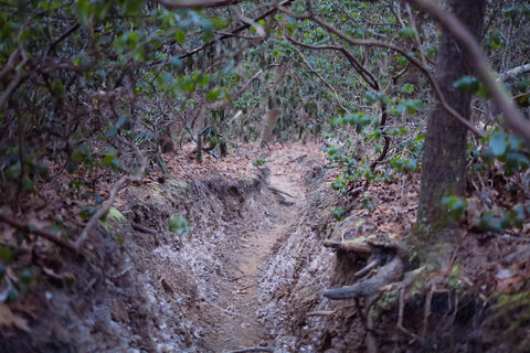
At 0.17 miles long, the Cloud Splitter Trail is unmistakable and easy to discern as it is heavily eroded with deep trenches and gnarled tree roots sprouting in every direction. So here’s the kicker, most people associate Cloud Splitter with the final roped climb to the top, but the truth is this hike contains a succession of 4 or 5 rock scrambles before even reaching the roped section. The first scramble starts at the base of the cliff and progressively gets steeper the higher one gets. In some areas I found myself grabbing onto tree roots just to pull my body up and over the ledges. Once you pull yourself up the rope hanging down from the summit, its a quick jaunt up the final 10 feet to the top. Walking up the sloped ridge to the forested peak, one gets the picture perfect image of Cloud Splitters namesake crevice. It might shock some to know that just below the summit, within the rock itself is a hidden cave containing one of the most unique arches in Red River Gorge, Cloud Splitter Arch. Earlier this year, the arch was heavily vandalized with graffiti which prompted the Forest Service to limit access to the cave.

The history of Cloud Splitter goes back possibly tens of thousands of years before the first Europeans ever set foot in what is now Kentucky. Some of the most famous overlooks in Red River Gorge, including this view from atop Cloud Splitter, were once used by the Adena Culture Peoples as lookout posts to guard against attacks from rival tribes. It’s no coincidence that Cloud Splitter, Hansens Point, Indian Staircase, and Chimney Rock all look out over Adena Meadows. This section of the Sheltowee Trace along the fertile valley of Chimney Rock Creek was used to farm crops that sustained a healthy population of prehistoric peoples that thrived here for centuries. Some of the best documented archeological excavations carried out in the Cloud Splitter Rockshelter are noted for uncovering parts of a 3,700 year old squash rind, along with an assortment of chipped and ground stone tools.

Sheltowee Arch
Leaving Cloud Splitter, I carefully retrace my steps off the mountain and head back to the Sheltowee Trace Trail. At the trail junction I turn LEFT to head back the way we came up from Sky Bridge Rd and continue along the Sheltowee Trace Trail east towards the Indian Staircase. Cloud Splitter is one of dozens of landmarks located along the northern terminus of this National Scenic Trail. With 319-miles of trail climbing between deep hemlock gorges and piney, craggy summits, the Sheltowee Trace is Kentuckys longest and most prestigious trail. Started by a U.S. Forest Service landscape architect named Verne Orndof in the 1970’s, the trail was inspired by some of the long distance foot paths pioneered by the Sierra Club on the east and west coasts of America. Beginning in Tennessees Pickett State Park, the trail travels north through the Big South Fork into Kentucky and spans the entire height of the Daniel Boone National Forest, ending in the town of Morehead.

If you’re into lush green forests and the vibrant colors of wildflowers, then summer is the time for you to tackle this hike. For me I prefer the quiet and solitude that winter brings to the area. Quite possibly the only downside to hitting this trail in winter is that you’ll encounter lots of downed trees. The Sheltowee Trace Association maintains and actively builds new sections of this trail, but their work crew programs don’t begin until mid-spring. In all, there were three felled trees blocking this trail that required some rerouting to get past. One instance of rerouting took me up the minor tributary of Greasy Branch to coincidentally discover another arch, Sheltowee Arch.

Sheltowee Arch was first documented by the legendary arch hunter Bill Patrick in his Arches of Red River Gorge DVD Volume 4. This span looks identical to Cascade Bridge in Carter Caves State Park, but is three times bigger. Running all along the inside edge of this formation are a series of fractures that are actively splitting Sheltowee Arch away from the cliff wall. The largest of these is a long window directly in the center of the arch. As a bonus, the arch also has an expansive rock shelter worth exploring. Getting back on track, the next landmark on my agenda is an oldie, but a goodie…. Sheltowee Twin Windows.

Sheltowee Twin Windows
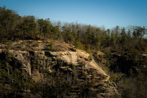
This double span is located midway along the climb to Indian Arch. It’s appearance as two pointed cat ears have spawned a litany of nicknames including Cat Ears, Cats Eyes, and Little Adena. A small side path just off the main trail takes you behind a dense grove of rhododendrons to the arches which are only a foot high and wide. I wonder how many people have walked right past here without a single clue that these twin windows exist just a stones throw away. A little further from this spot continuing our climb are a series of bald crags with excellent views of Indian Staircase. Though the bottom half of the climb is obscured by the forest, the top half is clearly visible. Even on a cloudy day, the well worn path with its signature notches is clearly visible from several miles away.

Finishing the steep ascent to the ridge top where most of the days landmarks reside, we quickly reach the gorgeous span of Indian Arch. This larger than life arch spans 39 feet across the Sheltowee Trace Trail, at the edge of a massive cliff. Walking under it to the backside, one can see a pocket cave and shelf situated on one end of it large enough for a person to sit inside of. To see this arches complete size and scope, you have to travel down the steps along the Sheltowee Trace Trail to see how tall this structure truly is. Even with all of the bumps and bruises Indian Arch has received due to its prominent location, this is one of the most elegant and graceful arches in Red River Gorge, if not the entire Daniel Boone National Forest.
Indian Arch
Indian Arch is a major intersection for the Sheltowee Trace and the unofficial trail system in this area. If your goal is to climb Indian Staircase, then continue down the steep flight of stairs roughly another 0.50 mile to the beginning of the Staircase ascent. It’ll be easy to spot as its in a large clearing with a wide and well traveled path to the LEFT of the main trail, just like at Cloud Splitter. There are a lot of websites and blogs out there that boast “the staircase is so easy even kids can do it”. Personally I would take those comments with a grain of salt. The climb is incredibly steep and slippery with nothing to guard you from falling backwards down the cliff on all three sides. I have personally witnessed grown men and women have emotional breakdowns, while in tears beg for help as they are physically frozen from fear and unable to progress up to the top. I have also watched people walk up the cliff and exclaim that it was a walk in the park. It all depends on your personal level of comfort and skill.

As for us, we are headed to see another hidden landmark, Adena Arch. The unofficial trail to Adena Arch is directly across from Indian Arch and the staircase leading down the Sheltowee Trace Trail. Just look for a clearing with a wide trail leading away from the arch. (On a side note, there are two other less used trails to Adena Arch from Sky Bridge Rd, but because they are more of a climb than a hike, they’re rarely used by most people.)Following the well worn Adena Arch Trail takes us on a 0.42 mile path along the top of a solitary wooded ridge. After going down a few short scrambles, I take a LEFT at the “Y” intersection and walk up a craggy bald to the opening of the arch. The span of Adena Arch arises directly from the top of this ridge like a giant kids slide and rounds back down over a cave in the center of it.

Adena Arch
This entire ridge is known for some of its amazing overlooks with unmatched vistas of the Gladie Creek Valley. One of my personal favorites is from atop the arch, although the walk up might be more than some people can stomach. Walking over to the arch opening reveals a sizable cave hidden below, which opens up to a large overlook. Adena Arch is a good example of what is known as a “pothole” arch. This type of arch forms when a pothole (small depression) on top of a rock mass merges with an alcove on a rock face. The light opening is often smooth and rounded at the top, casting light down into a room shaped opening below.

More famous than the arch itself is the large carved stone within it, known as Sandy. To some, this naturally formed bench looks like some sort of lizard creature. The area outside of this arch is a popular camping spot, but as of the 2022 season the Forest Service will be closing down several dozen of these illegal back country camping spots in order to let the areas rehabilitate. Leaving Adena Arch, head back the way you came towards Indian Arch to complete this 1 mile side trip. At this point we’ve reached the end of the one way hike to begin the Indian Staircase Loop and the start of our back country navigation.

The trailhead for the Indian Staircase Loop begins just a few dozen feet before reaching Indian Arch along the Sheltowee Trace Trail. If you backtrack from Indian Arch down towards Sheltowee Twin Windows, you should be able to spot a tall metal trail marker exactly in front of an unofficial side trail that climbs over a ledge and to the RIGHT of the Sheltowee Trace Trail. This is where things can get a little confusing without the aid of a GPS Navigation App. With so many people making their own way over this ridge to the top of Indian Staircase, it has left the area with an overabundance of intertwining trails that sometimes lead to nowhere. The important thing to remember is to follow the cliff line on the right hand side.

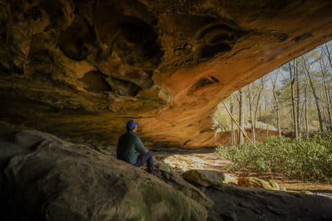
Council Chamber Rockshelter
En route to the staircase is another landmark, arguably the most famous rock house in Red River Gorge, the Council Chamber Rockshelter. There is a smaller trail that loops to the bottom and over the top of this rock house which runs adjacent to the Indian Staircase Loop. I opted to follow the main trail and scramble over a series of ledges on the eastern end of the rockshelter to reach it. On a good day when the water is flowing, one can hear Council Chamber Falls as they’re approaching, clueing hikers in to its location. At over 100 yards long, its depth of scope is hard to imagine without seeing it firsthand. Directly under the seasonal waterfall is a concave dome similar to those found in Mammoth Cave National Park. Known as the “Ohem Dome”, it produces an echoing vibration created by sticking your head up into the dome and loudly chanting a hymn.

It is a broadly held belief that Council Chamber was one of the main settlements of the Adena Culture Peoples while they lived in the Red River Gorge. In the last 20 years, the gorge has seen its prominence within natural history rise as it has become the epicenter of study for prehistoric plant domestication. Weedy annuals like sunflower, sumpweed, goosefoot, may grass, and squashes were grown in hill slope and flood plains gardens, with the best and largest crops being reserved for future planting. Until recently, there were thought to be only 5 regions of prehistoric plant domestication throughout the world; Mexico (corn), Peru (potatoes), the Middle East (wheat and barley), Africa (soybeans and millet), and east Asia (rice). With evidence spearheaded by research conducted specifically at Red River Gorge, archeologists have unearthed a cache of evidence that our ancestors in North Americas Eastern Woodland were also domesticating plants at a large scale.
Seeking refuge from the dangers posed by seasonal flooding from the Red River, predatory animals, and warring tribes, the inhabitants of the gorge abandoned their lowland sites for higher ground. All throughout the face of this cliff as it extends to Indian Staircase are a series of shallow caves that were used as cliff dwellings by prehistoric people. Though there is no definitive proof, it is another widely held belief that prehistoric peoples built the trail and carved the notches atop Indian Staircase.

One of the ways in which prehistoric peoples left evidence of their existence can be found on boulders scattered throughout the area in the form of simple geometric carvings known as petroglyphs. The Indian Staircase Petroglyphs are a series of concentric circles, roughly the size of a half-dollar coin, carved by hand on a slab of rock found in Council Chamber. Of the 70 confirmed petroglyph sites in Kentucky, nearly a dozen exist within the Red River Gorge. It is one of the main pieces of evidence some archeologists point to that Indian Staircase was not created by settlers in the 1700’s, but goes back some 4,000 years.

Shawnee Arch (Gnome Arch)
Leaving the Council Chamber Rockshelter on its eastern end, I scramble back up to the ridge and continue following the cliff heading east to Indian Staircase. Upon exiting the forested ridge top to the bald cliffs the views open up as far as the eye can see. The Gladie Creek Valley is the most prominent of the gorges seen straight ahead near the Visitors Center. Down below, viewable through trees that have yet to leaf out, is a portion of the Sheltowee Trace Trail. Looking back to the far right towards Council Chamber, one can see the full scope of just how large that rockshelter truly is. Just before reaching the top of Indian Staircase, the ridge folds down several times like a giant staircase, with a very unique arch situated at the far end.

Shawnee Arch is unique amongst the arches in Red River Gorge because it is essentially just a hole in the ground with a 100 foot free fall below it. It is thought that at one point this was a natural bridge with a wet weather stream running through the opening. Shawnee Arch came to prominence in the early 1980’s when the sport of rappelling made its debut at the gorge. As part of local lore, rappelling enthusiasts would tie off to a tree just above the arch and rappel through the opening just for fun. This helped earn the arch its more popular nickname, Gnome Arch. On a warm and sunny day, the ledges surrounding this arch are typically full of hikers picnicking while enjoying the open vistas.

Indian Staircase
Just a stones throw from Shawnee Arch is the end of our trek at the top of Indian Staircase. If it weren’t for the people panting and whining as they scrambled up the craggy slope, you would never know this was a well traveled trail. The staircase is so steep that the lower two thirds of the climb lay out of sight from those standing on the summit. The Indian Staircase has been gaining more and more notoriety as a bucket list hike, which has brought with it a mix bag of attention. Its not uncommon for people with very little experience hiking to piece together the route to the staircase, climb it, and then be completely aghast as to how they’re going to get back to their car. During several visits to this spot, I have had to personally guide people off the ridge to the Sheltowee Trace Trail and point them to the direction of their parking spot. While I am always happy to help, it certainly displays a broader need of education and skills set development amongst outdoor enthusiasts.

For those that plan on continuing past Indian Arch down the Sheltowee Trace to climb up Indian Staircase, simply retrace my excursion through the Council Chamber Rockshelter and follow the Indian Staircase Loop back to Indian Arch. Unless you were lucky enough to travel with two cars, leaving one at Bison Way Trailhead, you’ll have to travel back the way you came from Cloud Splitter to finish this hike. If you were unable to locate the Cloud Splitter Shortcut Trail and had to begin from the Sheltowee Trace Connector on Sky Bridge Road, you are still in luck. Along this stretch of trail is a small off-trail path leading to one of the areas largest rock shelters, named the Sand Castle, and a bonus arch, Sheltowee Shelf Arch. Up next, I’ll be heading over to the Martins Fork Trailhead to explore the hidden arches of Military Wall and Left Flank Wall along the Rough Trail. Stay tuned and as always, see y’all on the trails!


1 comment
Stumbled upon this as I have been hiking the gorge a lot lately. Very very informative post, thank you! You really really inspired me to know more history about the places I’m visiting! and to start a blog of my travels one day :) thank you. happy trails