
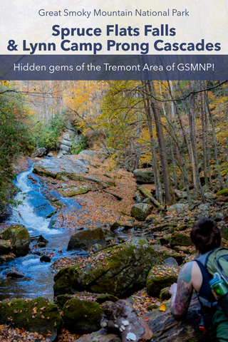
A visit to Spruce Flats Falls and Lynn Camp Prong Cascades are two of the most family friendly and off the beaten path hikes everyone should attempt in the Great Smoky Mountains National Park. Located in the Tremont area, the natural beauty and idillic scenery of this valley is considered one of the best kept secrets of the park. Though not officially on the park map, Spruce Flats Falls can be reached via an adventurous 1.6 mile trek on the Buckeye Trail beginning at the Great Smoky Mountain Institute at Tremont. A short drive further on Upper Tremont Road will take you to an easy 0.3 mile hike on the Middle Prong Trail to Lynn Camp Prong Cascades. While most visitors walk a little further to see the small tiered Lynn Camp Falls, the cascades are little visited and easily the best part of the show.
Buckeye Trail to Spruce Flats Falls | 1.6 Miles
Spruce Flats Falls Trailhead | Google Maps
Spruce Flats Falls Trail | Alltrails
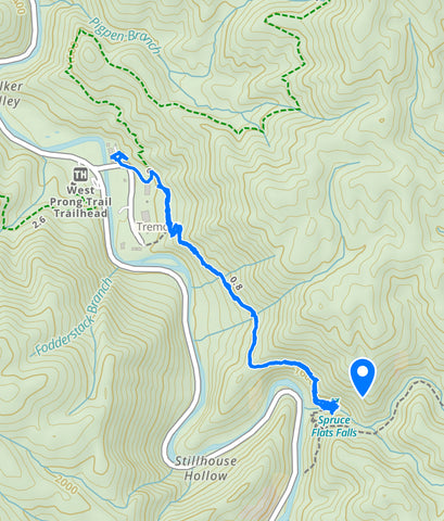
Approximate route for Buckeye Trail to Spruce Flats Falls via Gaia App.
Getting There
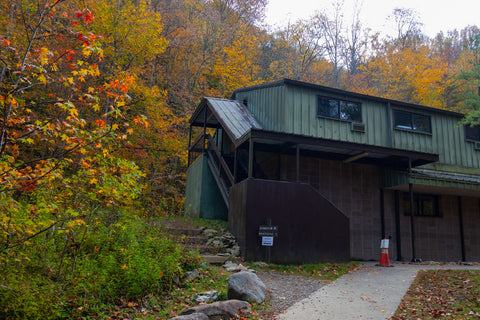
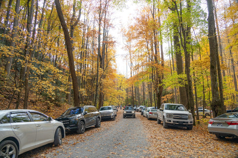
Considered a closely guarded secret by locals, the Tremont area of the Great Smoky Mountains National Park is one that your average tourist simply drives past without a clue as to what they’re missing. Thought to be one of the most beautiful and idilic valleys within the park, it was the last stretch of old growth forest logged before the National Park Service took possession of it back in 1941. Today it serves as the headquarters of the Great Smoky Mountain Institute at Tremont and offers seasonal opportunities for camping, fishing, swimming, and of course hiking. Tremont can be easily reached from the Townsend Entrance Rd to GSMNP, halfway between Cades Cove and Sugarlands. There is only one way in and one way out of here along Tremont Road. Once you drive past the Tremont Ranger Station, keep an eye out for the Tremont Visitors Center and Great Smoky Mountains Institute. Cross the bridge and park in the lot near the Visitors Center on the far left.
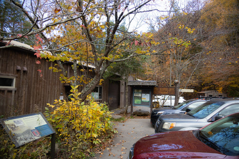
Parking lot for visitors center at Tremont in the Great Smoky Mountain National Park.
Buckeye Trailhead to Spruce Flat Falls (1.6 miles)
Though Spruce Flats Falls is not mentioned on any official GSMNP maps, it is a such a sought after landmark that the Park Service began erecting signs directing visitors to the falls in the early 2000’s. Nobody knows for sure how the trail originated, but it is believed that it began as a small nature path from the original Youth Conservation Corps camp situated here in the 1970’s. Once parked in the Tremont parking area, walk on over to the Lumber Ridge Trailhead just east of the Visitors Center along a gravel service road that is typically blocked off. This will take you a short distance to one of the recreational buildings of the Tremont Institute. Follow the signs guiding hikers around the back of the building to a clearing in the woods where you will find the official Lumber Ridge Trailhead. It is a brisk 0.1 mile walk on the Lumber Ridge Trail to a trail junction where you’ll see a sign for the Buckeye Trail \ Spruce Flats Falls Trail. Turn RIGHT at this intersection.
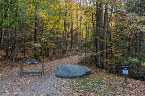
Follow the waterfall signs towards the Lumber Ridge Trailhead.
The Lumber Ridge Trailhead is right behind this red building for the Great Smoky Mountain Institute at Tremont.
Initial climbing up a series of switchbacks, this trail continues past a large water tower as it takes you on a small sightseeing tour overtop the sprawling campus of the Tremont Institutes facilities. After about a quarter mile the rest of the Buckeye Trail proceeds to weave in and out of a half dozen picturesque ravines on the south bank of Mill Ridge. Each of these wet-weather streams feeds into the much larger Middle Prong Little River a few hundred feet below. While the trail is fairly level in some parts, it is mostly rough going with a ton of rocks and tree roots to contend with. Mostly shaded under a dense canopy, there are two magnificent overlooks on the Buckeye Trail with distant views of the surrounding ridges that make up Walker Valley. The farthest peak visible on the first clearing is that of Thunderhead Mountain, which lies on the Tennessee\North Carolina state line. Another larger overlook is directed towards the far reaches of Spruce Flats Branch. The audible sounds of rushing water will become apparent from this point forward.
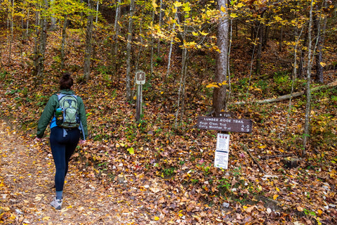
Follow the Lumber Ridge Trail a short distance to the Buckeye Trail and turn RIGHT. This is the start of the Unofficial Spruce Flats Falls Trail.

Most visitors to the Great Smoky Mountains have never heard of Tremont or Spruce Flats Falls making this a little known gem.
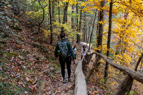
From here on out, the Buckeye Trail begins a progressively steep decent into this narrow valley with the audible sounds of rushing water becoming more apparent from this point forward. Scrambling down a few rocky ledges in the path, the last major descent is a lot more enjoyable thanks to a hand hewn log staircase. It is only wide enough for one person to traverse at a time so this can sometimes become a traffic jam if the trail is busy. Now you’re just a hundred yards shy of rounding the corner to the lower banks of Spruce Flats Branch and its namesake waterfall.
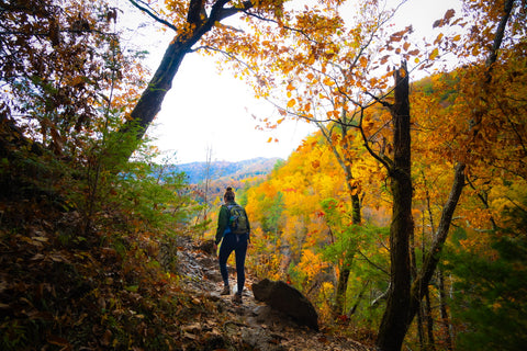
This is the first of two small overlooks towards Thunderhead Mountain on the North Carolina state line. Just look at those autumn colors!
Walking down the log steps on the final descent to Spruce Flats Falls.
Spruce Flats Falls (30 feet tall)
Often mistaken for Lower Spruce Flats Falls, which is viewable from a pull-off on Tremont Road, the main waterfall is further upstream and consists of a four tier drop totaling 60 feet in height. Putting them all together from its precipice to where it drains into the Middle Prong Little River makes this waterfall one of the largest in the park. Taking center stage near the end of this trail is the 30 foot main drop which forms a gorgeous and finely detailed veil cascade that empties into a still pool. One of the many reasons why this is such a photographed waterfall is because of the gnarled and weathered birch tree growing in a weeping form over the still pool. The scene here, especially during fall harkens back images of secret gardens in ancient castles.
The first three tiers of Spruce Flats Falls 60’ foot drop and the first view of the falls most people get.
The most photographed portion of Spruce Flats Falls is the middle 30’ foot drop. With this leaning birch tree that resembles a bonsai it is one of the most photogenic waterfalls in the state.
Another vantage point of Spruce Flats Falls from the cliffs above. Can you spot the people down below?
Lynn Camp Prong Cascades
Middle Prong Trail to Lynn Camp Prong Cascades | 0.3 Miles
Middle Prong Trailhead Location | Google Maps
Lynn Camp Prong via Middle Prong Trail Map | Alltrails
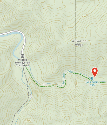
Approximate route of Middle Prong Trail to Lynn Camp Prong Cascades via Gaia App.
Getting There
After leaving Spruce Flats Falls, we retrace our steps on the Buckeye Trail to our car and depart the Visitors Center area for our next stop at Lynn Camp Prong Cascades. Exiting the parking area and crossing over the bridge, make a left hand turn (south) onto Tremont Rd and continue driving 3.3 miles until the road ends at the Middle Prong Trailhead parking area. Weaving through the heavily forested Walker Valley while following the Middle Prong Little River, this gravel lined road is one of the more scenic drives in the whole park. Small pull-offs along the side of the road allow visitors a chance to stop and check out some of the many smaller waterfalls and cascades found along the way.
Parking lot for Middle Prong Trailhead. Visiting on a weekend will get you a parking spot wayyy down Tremont Rd.
Middle Prong Trailhead to Lynn Camp Prong Cascades (0.3 miles)
Tremont Road ends at a fairly large roundabout parking area surrounded by the confluence of Lynn Camp Prong and Thunderhead Prong. This is the headwaters of the Middle Prong Little River and one of the last places to be logged in the entire Great Smoky Mountains. Before becoming a part of the national park, the official town of Tremont was located at this site. Home to over 30 families, Tremont consisted of a post office, hotel, maintenance sheds, a general store, and a community center that served as a church, school, and movie theater. Operated by the Little River Lumber Company, Tremont Rd originally served as the foundation for a rail line that transported felled trees down the Middle Prong Little River all the way to the city of Townsend.
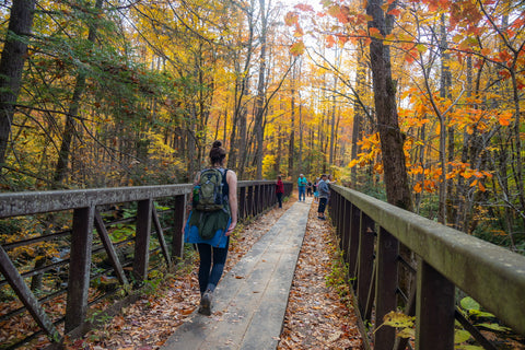
Walking across Thunderhead Prong on this historic steel bridge near the Middle Prong Trailhead.
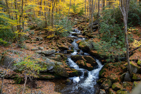
This is one of the last areas in the Smoky Mountains to be logged. There are gorgeous little waterfalls and boulder filled cascades everywhere you look.
You can see a remnant of this history as you walk across the steel girdle bridge marking the start of the 4.2 mile Middle Prong Trail. There is a 360 degree view of small waterfalls and boulder filled cascades in every direction from this vantage point. Despite this trails overall length, we will only be hiking a quick 0.3 miles uphill to the spot of Lynn Camp Prong Cascades. Unlike our first spot at Spruce Flats Falls, this is a well known waterfall and the National Park Service advertises its location. It helps to do a little research beforehand to know what the cascades look like as you approach them on the lefthand side. Like most of oldest established trails in the park, the Middle prong Trail got its start as part of a rail line for old logging operations. Makeshift shanty towns were continuously moved up Lynn Camp Prong as logging progressed deeper into the valley and if you look closely amongst the piles of leaf litter you can spot a stray rail road beam leftover from this era.
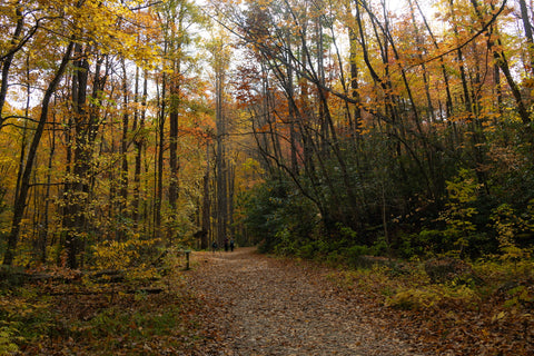
It is a quick 0.3 mile walk up this old logging railroad bed to Lynn Camp Prong Cascades.
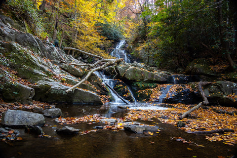
Lynn Camp Prong Cascades “Lower Cascades” (55’ ft high)
After a quick 15 minute walk, we were able to make out what looks like the smooth angled slide of Lynn Camp Prong Cascade off in the distance. The site of the cascades are marked by a seating area with a hand sewn log bench. This is the most photographed view of Lynn Camp Prong Cascades as it captures the entire run of the Lower Cascades. Lynn Camp Prong Cascades consists of several small waterfalls and cascades that stretch over a 0.25 mile length. The upper cascade is 35 feet long, the middle cascade is 85 feet long and the lower cascade is 55 feet long. At the end the lower cascade drops 10 feet into the plunge pool. Total drop is 65 feet from the upper cascade to the plunge pool.
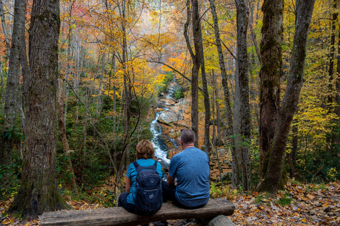
Look for this log bench marking the Lower Cascade of Lynn Camp Prong Cascades.
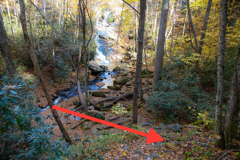
This is the user made path to get down to the banks of Lynn Camp Prong. It is a little rough, but if you take your time it is manageable.
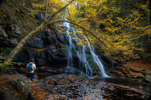
Looking around for a way to get down into the valley to see this up close, we realized that the bench was positioned in a way that hides the visitor made trail heading down to the banks of Lynn Camp Prong. The scramble down is steep and jagged, but with enough care can be managed by most people. From up close, you can make out Lynn Camp Prong Cascades iconic “swirl” as it travels down the 55 ft’ high lower cascades into the plunge pool. This is one waterfall you want to see with a moderate flow as opposed to heavy flow because with enough consistent rain the entire slide will be covered up by a torrent of water. You could take the time to travel up the remainder 0.25 of trail to see the middle and upper cascades, but in my opinion this is the creme de la creme right here. Also don’t forget that 3.0 miles further up the Middle Prong Trail is Indian Flats Falls. This 20’ ft tall waterfall is another gem of the Tremont area, but its 8.0 mile length makes it a little visited spot.
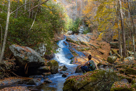
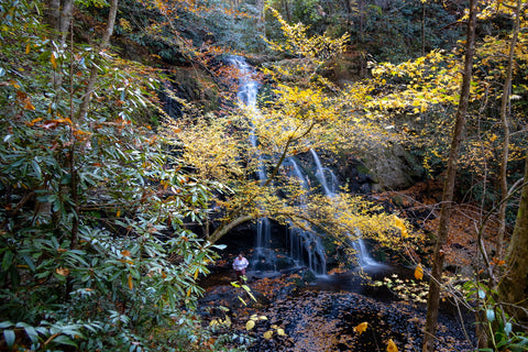
Even though Lynn Camp Prong Cascades runs for nearly 0.25 miles, this is the prettiest section and most picturesque section.
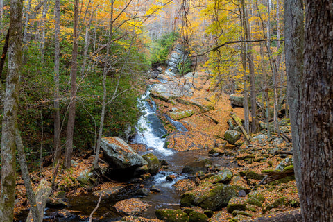
The photo everyone sees of Lynn Camp Prong Cascades is actually the 55’ foot Lower Cascade.
Up next, we’re headed closer to the heart of the Great Smoky Mountains National Park to hit up two popular waterfalls near the Sugarlands Visitors Center. Laurel Falls and Cataract Falls are the two most accessible waterfalls in the Smokies with short, family friendly, and mostly paved trails. The Laurel Falls Trail leads to an 80’ ft high waterfall, named after the mountain laurel shrubs that bloom along the trail and near the falls in May. This waterfall has an upper and lower section, divided by a walkway crossing the stream at the base of the upper falls. A quiet nature walk directly behind the visitors center meanders its way to Cataract Falls 25’ ft tall gentle cascade. No trip to the Smokies would be complete without a stop to these two easy to see gems so stay tuned to our upcoming article and as always, see y’all on the trails!


0 comments