

The stunning scenery and panoramic views from atop Pickens Nose rocky summit leaves little to wonder why this is the most photographed spot in the Southern Nantahala Wilderness. This easy 0.75 mile trail climbs through dense thickets of rhododendrons to the 4,829 ft summit of Pickens Nose and several other lookout points. Located in the Standing Indian Section of the Nantahala National Forest just south of Franklin and extending into Northern Georgia, this is one of the more remote areas in all of North Carolina. Difficult to reach by road, this area contains over 30 miles of the Appalachian Trail and noteworthy scenic areas such Mooney Falls and Big Laurel Falls.
Pickens Nose Trail | 0.75 Miles
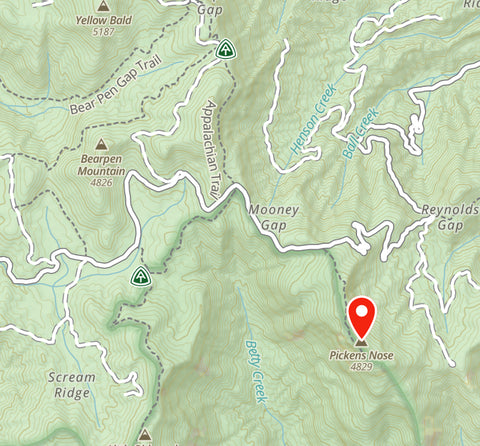
Pickens Nose Trailhead Location | Google Maps
Nantahala National Forest Trail Map
Overview of Pickens Nose Trail via Gaia App.
Getting There
While scenic views are easy to come by throughout the mountains of Western North Carolina, the uniqueness of Pickens Nose “beak-like” summit jutting skyward is something that makes it a popular bucket list destination worth seeking out. Considered a rarity, Pickens Nose “cantilever” ledge, along with McAffee Knob in Virginia, are two of the most photographed spots along the entire Appalachian Trail. Only 45 minutes south of Franklin, North Carolina, this area is commonly entered through the Cowee Hydrological Research Station along Ball Creek Rd (Forest Road 83). From the research station, it is a 5 mile drive up this narrow and winding gravel road to the Pickens Nose Trailhead. While Google Maps has accurate directions to the trailhead, service becomes spotty in the backcountry and we got turned around at two intersections. Our Gaia App, which we use on all of our backcountry trips, helped guide us the rest of the way.
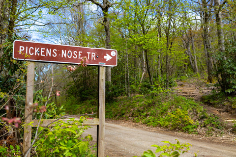
Pickens Nose trailhead along Ball Creek Rd (FR 83).
Pickens Nose Trail (0.75 miles)
Upon ascending a series of sharp switchbacks along Forest Road 83, the Pickens Nose Trailhead sign will appear on your righthand side. There are two parking areas here on both sides of the road capable of fitting 3-5 cars within a small turnaround. Though hard to discern at first, the actual trail is located on the south side of the road and begins through a narrow clearing surrounded by a dense thicket of rhododendrons. It is a 50 ft ascent from the trailhead to the top of the ridge. Most of this hikes 0.75 mile length will remind you of the trails surrounding Craggy Gardens, along the Blue Ridge Parkway, as it cuts through a tangle of gnarled and weathered rhododendron tunnels. The ascent is steep and mostly made up of climbing up and over tree roots surrounding large boulders. Visit during the rhododendron blooming season in June and this dark and dreary path will be glowing with a tapestry of colors.
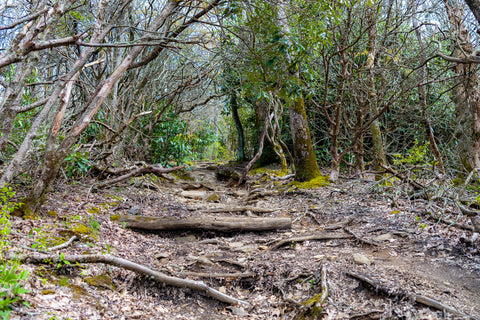
Most of the Pickens Nose Trail consists of a short, steady climb up tree roots to the main ridge line.
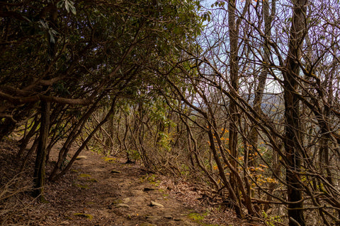
This trail resembles the Craggy Gardens Trail system along the Blue Ridge Parkway near Asheville.
As we reach the crest of the ridge the forest canopy gives way to our first look out over the southern range of the Nantahala Mountains. Several paths will appear on both sides of the trail which head out to overlooks facing east and of the mountain, with the trail ending at the proper 4,829 ft summit of Pickens Nose. The path leading out to the Pickens Nose ledge (different from the actual summit) will be the second to last one to appear on the right facing west. You’ll enter through a tangle of rhododendron which leads to a boulder scramble down to the ledge. Exercise extreme caution while exploring these ledges as there or no railings or barricades here. When we first walked out onto it we weren’t sure if this was the right spot. One of the best views of the ledge and its peculiar shape is from the lookout right beside it on the left. This is where most people get that iconic photograph of the slim ledge jutting out skyward. Though pictures make it seem like visitors are propped up on a death defying slim piece of rock, the ledge is actually quite wide and roomy when standing on top of it
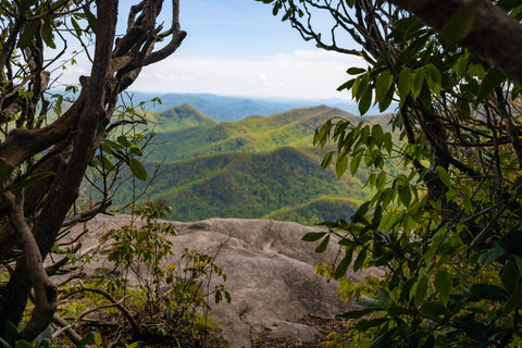
Your first sneak peek of the beautiful Southern Nantahala Wilderness as you emerge out onto the cliffs.

Pickens Nose "bird-like" ledge jutting skywards is a bucket list destination along the Appalachian Trail in North Carolina.
The Views
It is hard to imagine that only 100 years ago everything we see stretching out across the ridge tops and valleys below was clear cut. Early settlers removed every piece of good timber that was at least 15 inches in diameter from all of the main drainages in the southern range of the Blue Ridge Mountains to feed a 50 year logging boom. Designated a “Wilderness” by Congress in 1984, The Southern Nantahala Wilderness stretches out for over 23,365 acres past Pickens Nose summit into Northern Georgia and contains the headwaters to the Nantahala, Hiwassee, and Tallulah Rivers. Predominantly made of of spruce and fir covered ridges, the area is also known for its grass-heath balds and unique bog ecosystems which support endangered species such as the bog turtle. The main view here facing west looks out over the Little Tennessee Valley and beyond. Looking north from the nose, just past the Betty Creek Valley below, you can spot the main ridge line that carries the Appalachian Trail. If you run over to the opposite side of the trail to the lookouts facing east, you’ll see the sprawling Southern Research Complex of the Cowee Hydrological Lab. Established in 1934, this experimental forest would prove to be the source of some of the most influential research on forested watersheds done in the world on top of being the oldest continuous environmental research station in the world.
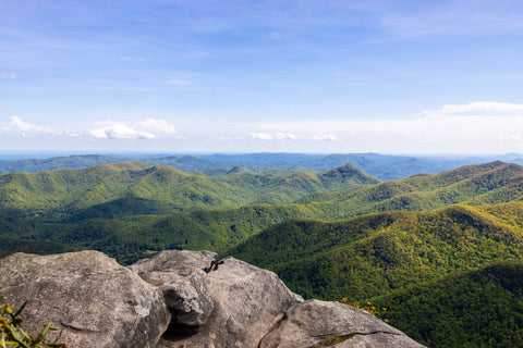
The mountains just go on forever from here. A total of over 23,000 acres of the Southern Nantahala Wilderness extend from this point south into Georgia.
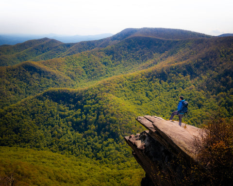
Epic photo ops at the end of this short 0.75 mile hike.
Up next, we’re continuing our exploration of the Southern Nantahala Wilderness by driving west along Ball Creek Rd (FR 83) to two of the areas most visited landmarks. Mooney Falls and Big Laurel Falls 50 ft drops are considered some of the tallest and most beautiful within the 23,365 acre Southern Nantahala Wilderness. Located only 1.5 miles apart, most visitors to the Standing Indian Area complete the short hikes to these waterfalls together for an easy day of waterfall chasing. Stay tuned for these upcoming articles and as always, see y’all on the trails!


0 comments