
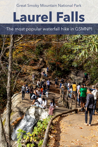
Laurel Falls is the most heavily visited waterfall in the Great Smoky Mountains National Park and for good reason. Only 2.6 miles roundtrip, the mostly paved and family friendly Laurel Falls Trail leads to an 80’ ft high waterfall only a short distance from the Sugarlands Visitors Center. Named after the mountain laurel shrubs that bloom alongside the trail, hikers will be treated to an incredible wildflower display near the falls each summer throughout the month of May. Divided into an upper and lower section, a walkway crossing the stream at the base of the upper falls leads to multiple viewpoints of this picturesque waterfall.
Laurel Falls Trail | 2.6 Miles
Laurel Falls Trailhead Location | Google Maps
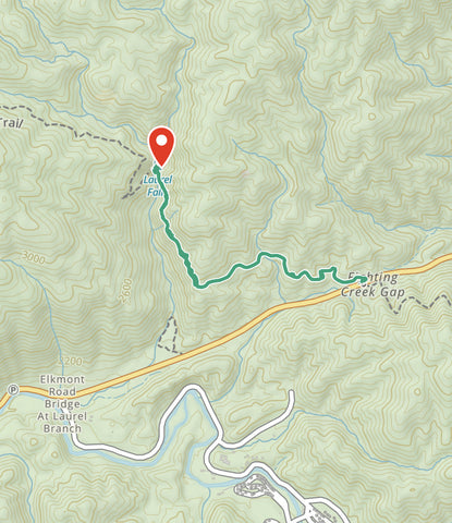
Approximate route of Laurel Falls Trail via Gaia App.
Getting There
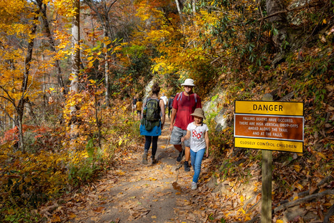
If you ask most visitors in Great Smoky Mountains National Park which waterfall they have visited, chances are it’s Laurel Falls. It’s hard to imagine any other trail that has everything the Smokies has to offer with the same amount of ease and accessibility, but with that comes a catch. This is one of the most heavily trafficked trailhead in the park. Unless you come during a weekday or in the off-season, chances are it is going to be hard to find a parking spot. If your plans are to enjoy a little peace and quiet in the woods or to practice your waterfall photography I would suggest tackling this trail either early in the morning or late in the evening. From Sugarlands Visitor Center, turn toward Cades Cove on Little River Road and drive 3.5 miles to the trailhead where there are parking areas on both sides of the road.

Laurel Falls is one of the busiest trailheads in the entire National Park. Come early in the morning or late in the afternoon for your chance to find a parking spot.
Laurel Falls Trail (2.6 miles)
The Laurel Falls Trail was built in 1932 to provide fire crews’ access to Cove Mountain in case a forest fire was to occur in the area. After reaching the falls, the Laurel Falls Trail continues another 2.75 miles uphill and intersects the Cove Mountain Trail to a short spur reaching the summit of Cove Mountain. In 1935 workers also completed the Cove Mountain Fire Tower. The trail quickly became a frequent path for hikers and by the 1960’s the trail began to experience high levels of erosion, leading to the pavement of the Laurel Falls trail by the Department of Interior in 1963. Laurel Falls trail is the longest and most popular of the four paved trails in Great Smoky Mountains National Park.
The Laurel Falls Trail is one of four paved trails in the Great Smoky Mountains National Park. Most of it is dated and crumbling, but it still does it’s primary job of controlling erosion along this path.
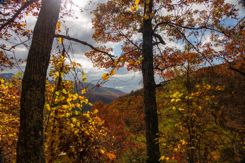 A panoramic view of Little River Gorge opens up as soon as you reach the Laurel Branch.
 This section of the Laurel Falls Trail has some serious steep drop-offs so mind your step.
 Laurel Falls viewable at the end of this cove.
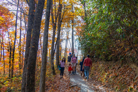
From the trailhead, the Laurel Falls Trail is a moderate 2.6 miles roundtrip with a steady incline of roughly 300 feet. Upon leaving the parking area, the sounds of traffic quickly disappear as you enter the heavily forested ravine of Pine Knot Branch. Several wet-weather streams cross over the trail in this section after heavy rains. The majority of this path entails a slow and steady climb towards the top of a steep ridge that leads directly into the much wider valley of Laurel Branch. This major tributary of Little River carves out the southeast corner of Chinquapin Knobs 3,753 summit. Once you reach the outer rim of Laurel Branch, you’ll spot the first and only major overlook on this trail. This is probably one of the best overhead views of the Little River Gorge in the park.

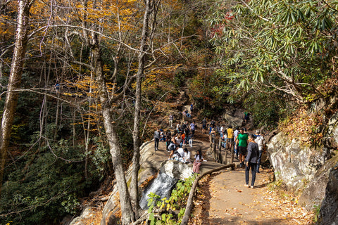
Can you tell that this is the most popular waterfall hike in the park?
 Upper Laurel Branch is to the left of the footbridge with the sheer 60 ft drop just to the right.
Laurel Falls (80’ ft high)
From this point it is a quick 0.75 miles to Laurel Falls. As you get near it, you’ll be able to spot the log bridge that cuts this 80’ foot waterfall in half at the far end of a cove. Upper Laurel Falls has two short tiers totaling 20 feet that cascade over one another into a small pool just below the bridge. After passing under the bridge, Laurel Branch takes a whopping 60’ ft sheer drop down the side of a cliff to the bottom of the valley. Here, rockfall surrounding the waterfalls basin enclose a popular swimming hole used by visitors all summer long.
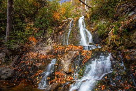
Laurel Falls two tiered 20’ ft Upper Falls is the most photographed and easily viewed from the footbridge.

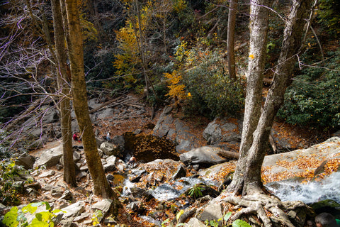
This is the view down to Lower Laurel Falls and the bottom of the valley. It is a long way down from here if you fall. You can see the steep user made trail in the far side of this photo leading to the lower falls. It involves several near vertical scrambles and is not recommended for kids.
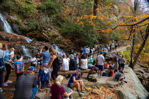
Laurel Falls empties into a natural pool surrounded by rockfall that serves as a swimming hole during the summer months. Note the people getting ready to jump in the water with temps in the lower 60’s!
Even with temperatures in the 60’s on our fall visit we could still find hikers wading in the stream. While there is a “user made” trail leading down to the lower falls it is very rough and involves a near vertical scramble. The trek is not recommended for young children or those with mobility issues. Avoid going on the rocks when they wet as this entire area is extremely slippery. After visiting Laurel Falls retrace your steps back to the parking area to finish off this hike. Up next, we’re headed over to the Cosby Campground to kick off an epic adventure to one of the most iconic landmarks in the Smoky Mountains. At 4,928, the lookout tower atop Mount Cammerer is one of the last remaining and accessible fire towers in the Great Smoky Mountains National Park. Stay tuned for this upcoming article and as always, see y’all on the trails!


0 comments