

One of the most spectacular canyons in the eastern United States, Tallulah Gorges two mile long and nearly 1,000 feet deep canyon is home to the five world famous waterfalls that make up the Tallulah Falls. Located in the historic town of Tallulah Falls, the gorge is listed as one of the seven wonders of Georgia and receives over half a million visitors each year. Designated a State Park in 1992, Tallulah Gorges 2,689 acres features over 20 miles of hiking trails exploring the parks numerous observation points and historical markers. By far the most popular, the 3.0 mile loop along the canyons North Rim Trail and South Rim Trail takes visitors on a journey over the canyons suspension bridge, to lookouts of L’Eau d’Or, Tempesta, Hurricane, and Oceana Falls, plus the site of the famous 1970 high-wire walk across Tallulah Gorge.
North Rim to South Rim Trail | 3.0 Mile Loop
Tallulah Gorge State Park Location | Google Maps
Tallulah Gorge State Park Trail Map
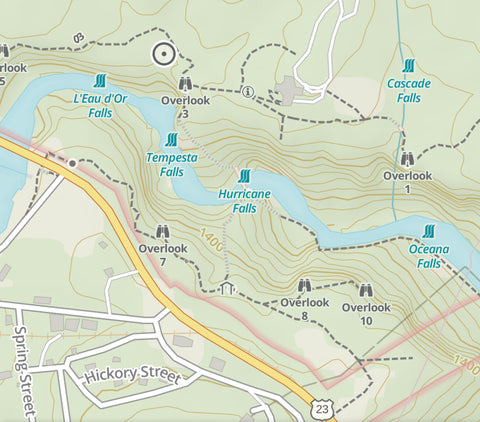
North Rim to South Rim Trail overview via Gaia App.
Getting There
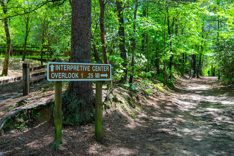
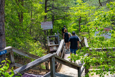
If you ever find yourself near the Northeast corner of Georgia, you MUST stop at this gem of a state park. On a recent multi-day trip chasing waterfalls near Highlands and Franklin, North Carolina I found myself just north of the border from Tallulah Gorge State Park so I decided to take the plunge and pay it a visit. Located just outside of Georgias famous resort community of Sky Valley, the park is only 45 minutes south from Franklin, N.C., 1 hr 30 min north of Atlanta, and 1 hr 30 min west of Greenville, S.C. There is a small $5 parking fee to enter Tallulah Gorge State Park by vehicle or if you’re a local, you can enter the park for free via two trailheads within the Terrora Day Use Area. Once inside the park, take a walk through the Jane Hurt Yarn Interpretive Center which highlights the areas rich history as a Victorian resort town during the late 1800’s. There is also an in depth exhibit on Karl Wallenda’s high-wire walk 1,000 ft across the gorge.
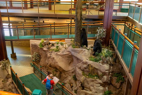
Exhibits inside the Jane Hurt Yarn Interpretive Center. The North Rim Trail begins just outside the back door.
North Rim Trail
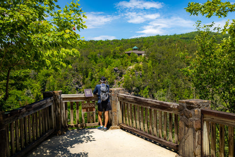
While Tallulah Gorge State Park features over 20 miles of hiking trails, almost 15 of those miles are on backcountry trails that border the Chattahoochee-Oconee National Forest or enter the adjacent Northern Wildlife Management Area. Most of the half million weekend visitors are here to see some jaw-dropping waterfalls and to walk across the suspension bridge, which makes the North Rim to South Rim Trail Loop the most hiked trail in the park. This loop is not for the faint of heart as it contains stops at 5 overlooks (10 total) on each 1.5 mile rim and a 1,200 stair combined descent and climb to reach the suspension bridge. To get there, just walk out the back of the Visitors Center and go down the paved path until it joins with the North Rim Trail some 40 yards away. Here, you’ll run smack into the middle of the North Rim Trail with options to turn LEFT towards Inspiration Point. There is no rhyme or reason to how you begin this loop, but we opted to start by visiting the overlooks in order and head to Inspiration Point first.
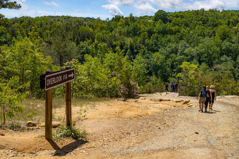
Walking down to Overlook 1A directly behind the Interpretive Center.
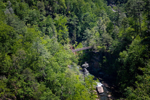
The Suspension Bridge as seen from Overlook 1A.... 600 ft below the North Rim of Tallulah Gorge.
Overlook 1A\1, Inspiration Point, & Oceana Falls
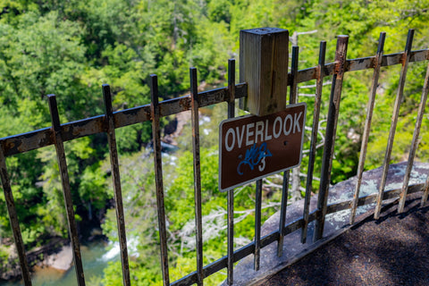
The first leg of this trail is the only part that really feels like a hike through the woods and less of a tourist attraction. From the Visitors Center, we took a LEFT onto the North Rim Trail and walked 100 feet to the first of 10 lookout points along the 3.0 mile loop. Overlook 1A is atop a craggy cliff with views directly over the suspension bridge and Hurricane Falls just below that. The view is absolutely incredible and really gives you a sense of the canyons 750 foot depth. Even the people walking across the bridge look like tiny ants from this high up. Past this we take another short stroll through a wooded picnic area, cross a small log bridge, and exit out onto Overlook 1. First and foremost on everyones mind when they reach this point is the giant steel tower leaning on its side. This is the site of Karl Wallenda’s high-wire walk across Tallulah Gorge in 1970. Two identical towers were erected, one here and one directly across the canyon on Overlook 9, to hold up the tight rope. With a crowd of over 30,000 spectators, it only took the 65-year old Wallenda an astonishing 18 minutes to complete the journey. During the walk he even comically performed two handstands.
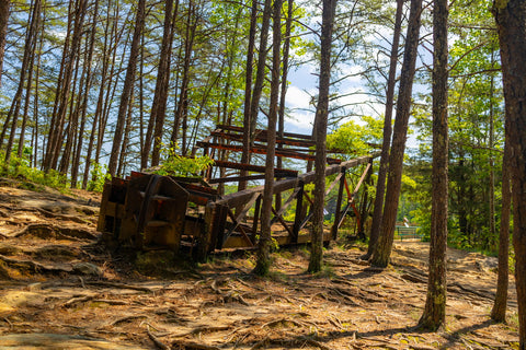
North Wallenda Tower laying on its side at Overlook 1. in 1970, Karl Wallenda walked 1,000 ft across the Tallulah Gorge suspended by this tower and another one on Overlook 9.
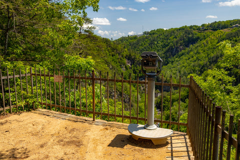
Quarter fed binoculars on Overlook 1.
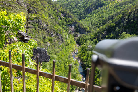
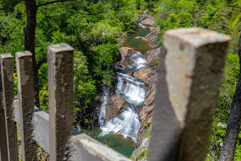
Looking south down the Tallulah Gorge with Oceana Falls directly below and Bridal Veil Falls at the far end of this view.
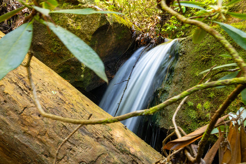
One of the many cascades of Cascade Falls before it plummets below Overlook 1.
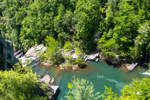
This overlook also has a quarter fed set of binoculars visitors can use to see far into the canyon. During periods of high precipitation, there is a bonus waterfall that is formed by a small creek named Cascade Falls which tumbles directly under this spot. Despite not being able to get a good view of it, we were able to hear it splashing down over the cliffs just below our feet. Inspiration Point is another short jaunt from here and offers views from the highest point in the park. If you look down you should be able to see a bend in the river with what looks like a small sliding cascade. This is the top of the 40 ft tall Oceana Falls. This is the fourth significant falls of the Tallulah River. Unless you plan on hiking the 3.0 mile Gorge Floor Trail or 0.5 mile Sliding Rock Trail to see Oceana Falls and Bridal Veil Falls a little further downstream this is the only view you’ll get of these waterfalls. Getting down into the gorge itself requires obtaining a free permit. Only 100 permits are handed out on a first come-first serve basis each day and usually sell out within the first opening hours.
One of the few trail markers and signs at Tallulah Gorge State Park. The trails lack signage, but are fairly easy to follow.
The obscure view or lack there of from Overlook 3.
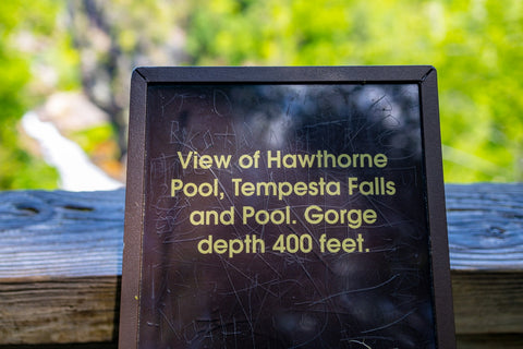
Overlooks 3 & 2, L’Eau d’Or Falls, & Hawthorne Pool
From Inspiration Point we back tracked nearly 0.35 miles to our starting point and headed straight for Overlooks 3 and 2. Both of these overlooks are nearly side by side and look directly out to L’Eau d’Or Falls (French for 'Water of Gold'). This three-tiered sliding waterfall is the first of the five major waterfalls that make up Tallulah Falls. Looking towards the top of the 35 ft waterfall, you can almost make out the ruins of the original Tallulah Falls Dam. Overlook 3 has some trees and brush partially obscuring the view of the falls, but it has a great view up the center of the gorge and the sheer cliff walls. Overlook 2 is surrounded by benches where visitors can pause to enjoy the sights and has access to a bluff that protrudes over the Hawthorne Pool. This is a very large natural pool which is situated between the bottom of L’Eau d’Or Falls and the precipice of Tempesta Falls. We went ahead and skipped Overlooks 4 & 5. Basically these lookouts are for people interested in seeing the new Tallulah River Dam and the Hwy 441 bridge.
L'eaur d'Or Falls 90 ft triple drop as seen from Overlook 2. This is a tough waterfall to photograph as there are few clear and unobstructed views of it from the North Rim Trail.
Hawthorne Pool directly below Overlook 2. You can see the precipice of Tempesta Falls on the far left of this picture.
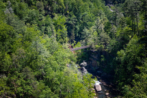
Suspension Bridge & Hurricane Falls
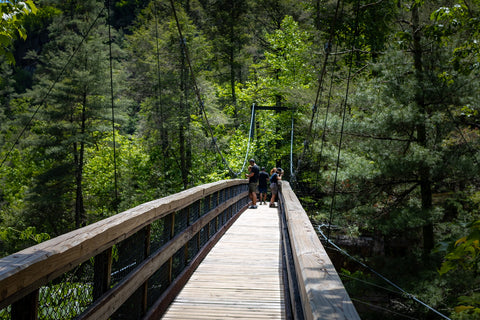
Crossing the Suspension Bridge some 600 ft deep in the heart of Tallulah Gorge.
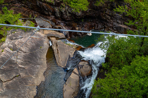
Looking down from the Suspension Bridge you're just 80 ft above the precipice of Hurricane Falls.
Getting to the Suspension Bridge is pretty straight forward. This is one of the most photographed spots in all of Tallulah Gorge State Park. The bridge sways 80 ft above the top of Hurricane Falls. Looking upstream the view of Tempesta Falls is blocked by a bend in the canyon, but we’ll get a chance to see that later from the South Rim Trail. Walking across the bridge, we make a LEFT TURN heading down to Hurricane Falls and the Gorge Floor Trail. It is another 60 stairs down the side of the cliff to the bottom of Tallulah Gorge and an observation deck directly in front of Hurricane Falls.
The Hurricane Falls observation platform at the bottom of another 60 stair descent from the Suspension Bridge.

This is the closest most visitors will get to a waterfall at Tallulah Gorge State Park.
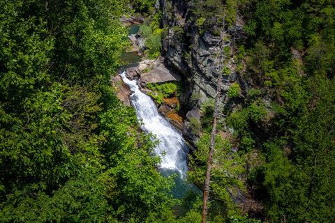
Clear view of Hurricane Falls from the observation platform.
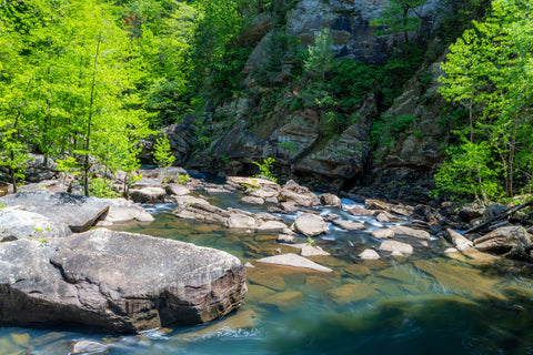
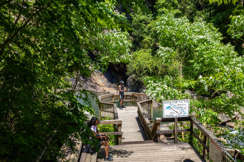
The 3.0 mile Gorge Floor Trail begins at the observation platform beside Hurricane Falls. The park issues 100 permits each day to hike this trail to Oceana and Bridal Veil Falls.
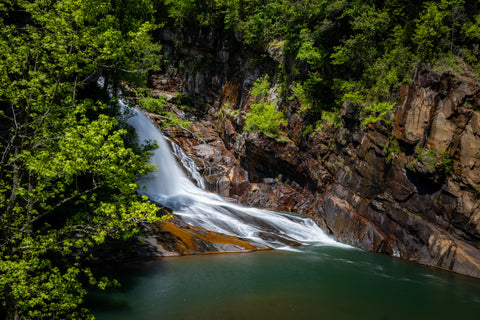
This 90 ft waterfall is made up of a chute with a sheer drop and subsequent slide which drops into a gorgeous natural pool. In my opinion this is the prettiest waterfall in the whole park. It is the third significant waterfall of Tallulah Falls and the farthest downstream anyone can travel without a permit. The start of the 3.0 mile Gorge Floor Trail starts here at a gated entrance. Anyone thinking that they can sneak off into the gorge without a permit should beware. Rangers are stationed throughout the trail and regularly turn back hikers who do not have permission to be down there.
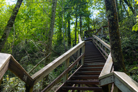
Another 300+ stairs up to reach the South Rim Trail from the Suspension Bridge.
Looking out towards Overlooks 8 & 9 from the South Rim of Tallulah Gorge.
South Rim Trail, Overlooks 6,7,8,9, & Tempesta Falls
The real challenge to todays 3.0 mile loop begins now as we have to start climbing the stairs back out of the gorge. From the Hurricane Falls overlook, we climb back up the 60 steps to the suspension bridge and make another LEFT TURN to proceed up the seven flights of stairs to the South Rim of Tallulah Gorge. After an exhausting trip up, the stairs exit out in the very center of the South Rim Trail with Overlooks 8 & 9 on the east side of the rim and Overlooks 6, 7, & Tempesta Falls on the west side. Seeing as it was a shorter trip, heading to Overlooks 8 & 9 first seemed like the right move. Overlook 8 is roughly 50 yards from the stairs and has a direct view across the gorge to the Jane Hurt Yarn Interpretive Center. This overlook also has a great view of the suspension bridge and a framed perspective of Hurricane Falls through some dense brush. Overlook 9 is a stones-throw away with its squatter and more petite Wallenda Tower. Oceana Falls slides downstream directly below the cliffs here, but its 40 ft height is lost from this vantage point. From this spot the South Rim Trail becomes the Sliding Rock Trail and continues another 0.50 mile to a 550 step metal staircase that descends to Bridal Veil Falls. Anyone continuing to Bridal Veil Falls must obtain a free Gorge Floor Permit beforehand.
Overlook 8 has views looking out directly at the North Rim and the Jane Hurt Yarn Interpretive Center.
Then Suspension Bridge down below Overlook 8 with a similar view as Overlook 1A.
Getting back on the South Rim Trail, Overlook 7 has a large shaded pavilion, but dense brush covers up any views of the gorge you might otherwise get. Highway 441 runs parallel to the trail and hits its narrowest point separating the two at this overlook so the road noise can get pretty loud at times. Continuing north a few dozen yards we reach the last lookout of the South Rim Trail and one of the best framed views in the park. Overlook 6 is the only spot in Tallulah Gorge where you can see directly out to Tempesta Falls. Even though it is directly below Overlook 2, it is nearly impossible to see. At 80 ft high, it is the second tallest and most significant waterfall of the Tallulah River. Unfortunately, this remote waterfall has no public access point. Guided ranger hikes to the Tempest Falls basin are offered sporadically and are the only way to see this gem up close. From this point it is another trip back down to the suspension bridge and up the 360 stairs to the North Rim Trail and the parking lot adjacent to the Jane Hurt Yarn Interpretive Center. Thankfully there is a water station and a few benches along the way to aid in the journey.
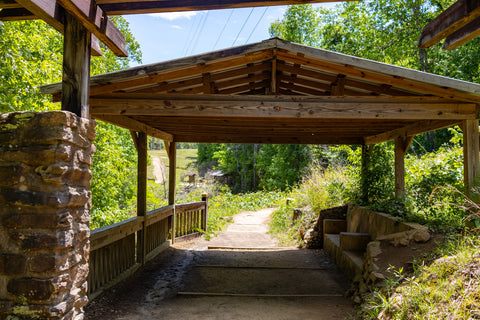
The pavilion at Overlook 7 offers some shade from the intense summer heat of Georgia, but not many views to speak of.
Reaching Overlook 6, the last on the South Rim Trail.
Tempesta Falls 80 ft drop can only be seen from Overlook 6 on the South Rim Trail. While there is no public access to this waterfall park rangers occasionally lead trips down to the base of this waterfall.
Up next, were headed back into North Carolina to explore some of the scenery of the Southern Nantahala Wilderness. Located in the Standing Indian Section of the Nantahala National Forest just south of Franklin and extending into Northern Georgia, this is one of the more remote areas in all of North Carolina. Difficult to reach by road, this area contains over 30 miles of the Appalachian Trail and noteworthy landmarks worth searching out such as Pickens Nose, Mooney Falls, and Big Laurel Falls. Stay tuned for these upcoming articles and as always, see y’all on the trails!


0 comments