


Boasting incredible views of some of Red River Gorge’s most iconic natural landmarks, Auxier Ridge to Courthouse Rock is considered one of the best day hikes in all of the gorge. Located in the northeast corner of the park, this 4.4 mile out and back trail follows a narrow ridge, traversing some rugged terrain over steep cliffs overlooking an endless valley. Along the way, you’ll encounter landmarks such as Ravens Rock, Haystack Rock, Wizards Backbone, Double Arch, and Courthouse Rock. Those who make the journey all the way to Courthouse Rock, may also choose to scale its summit, for an unparalleled view of what many refer to as ,“Heaven on Earth."

Our journey to Auxier Ridge began as many of our trips to the gorge do, following Campton Rd and turning onto Tunnel Ridge Rd. Crossing the one lane bridge over Mountain Parkway, we entered another famous part of the gorge, The Grays Arch Area. To reach the Auxier Ridge trailhead, continue along the dusty gravel road until it ends in the Auxier Ridge picnic area. As this is also the trailhead for Double Arch, most people tend to make a day of it and add it onto their hike to Courthouse Rock, creating a 6.50 mile loop. Its strenuous, but worthwhile.

We found our trailhead onto Auxier Ridge about midway through the farthest parking lot. This trail begins by descending deep into a heavily forested valley of beech and poplar. Most of this summers wildflowers have already faded as the fall months have begun to set in. Star shaped, woodland asters are starting to bloom, adding subtle pops of white among all of the browning foliage. While making our way down the ridge, we passed a short, but very long rock shelter on our left.

At this point, the trail begins ever so slowly ascending through the canopy until we find ourselves climbing over a notched sandstone cliff. We are now officially on top of Auxier Ridge. Over the next quarter mile, this trail forces hikers to climb over and back down a series of knobs, along the crest of the ridge. As the trail is mostly made up of broken down sandstone with bits of plant debris, it was hard at times to get a good footing without slipping. Portions of this trail started to resemble a HIIT workout, more so than a leisurely stroll through the woods.

Downed trees from this summers previous thunderstorms littered our path, adding a bit of ingenuity on our part as to how we should continue forward. Traversing these obstacles was made all the worthwhile whenever we would stumble upon another exposed cliff overlook. The valley below us was starting to open up and the views were getting better and better.

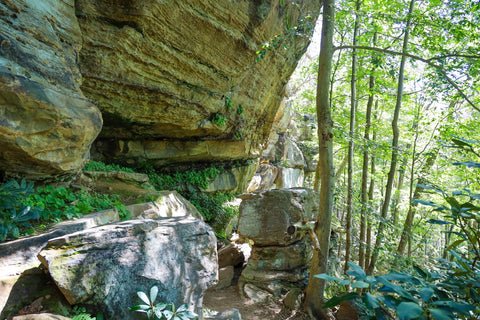
As we rounded a bend in our path, I came out of the brush to discover a magnificent looking rock shelter tucked beneath a towering hillside, with a fieldstone winding staircase. Deciding to stop here and take five, I marveled at how beautiful this part of Auxier Ridge looked. This trail was beginning to meet my expectations and so much more. There are plenty of trails I can hike closer to home, which would satisfy my cravings for being outdoors, but lack the overwhelming beauty of being somewhere as special as this place.

Climbing the steps onto the ridge above, we reached the Courthouse Rock Trail junction. Most people hiking Auxier Ridge, loop back south along Courthouse Rock Trail and come out at this point, unless they are continuing along to Double Arch. Just past this point, we find an exposed ridge, offering us our first glimpse of Courthouse Rock off in the distance.

Although most of this ridge is heavily wooded, there are clearings where wildflowers have managed to make a home, creating small meadows. I caught a pleasant whiff of cinnamon and fall spice from some of the blooming fall asters growing alongside some summer daisies.

Making our way past some thick brush, we entered one of the most recognized sections of Auxier Ridge, the Wizards Backbone. This thin and gnarled ridge with no soil to harbor plant growth, is completely exposed to the elements. Large potholes regularly fill with water, creating small reflection pools. This is easily one of the most photographed spots on the trail, besides Courthouse Rock.

Looking out into the distance, Ravens Rock can be seen standing guard over the valley below. Although Ravens Rock technically sits on private property, paying a small fee to park your car near the trailhead, just off of Nada Tunnel Rd, will give you access to hike its summit.

Walking over to the opposite side of the ridge, we spotted Haystack Rock, peeking just above the forest canopy. Haystack Rock is a popular bouldering and rock climbing spot and its not too uncommon to find someone attempting to scale its peak. The area just across from Wizards Backbone is a popular resting area for hikers.

A grove of pines on the top of this buttress, shade the surrounding exposed cliffs. Several people have taken to laying in hammocks while others pick out spots to sit while enjoying a mid-day picnic. We decided to move ahead and reach Courthouse Rock before stopping for a break.

This last stretch of Auxier Ridge requires some scrambling in order to get the best views. You can opt to hike around the boulders atop the ridge, and make your way to the staircase leading down into the valley if you’re not comfortable with heights. Every hike has some element of danger and people regularly die each year while hiking in the gorge, so please do exercise caution. Picking ourselves up over the ledge here, we slowly scrambled over several large boulders protruding out over the cliffs edge. Just like climbing over Half Moon Arch several months ago, stepping out at the edge of this ridge gives you a 180 degree view of unparalleled beauty.

Dead ahead is Courthouse Rock, with its wooded summit, standing guard over the area like a lighthouse at the waters edge. We headed back a bit, to an area that felt a bit safer to sit, and made this our picnic spot. While munching down a typical lunch of peanut butter and jelly sandwiches, chocolate covered nuts, and an assortment of greasy chips, I spotted what looked like a cave on the other side of the valley in front of us.

Looking over the map, I noticed that I was looking in the direction of Double Arch. Using the zoom on my camera, I pointed the lens back in the direction to spot exactly just that, Double Arch. Not only that, but I could make out people hiking into the arch and looking straight back at us.

After much debate as to which route we would take back towards the parking area, we eventually agreed on heading down into the valley and looping back south along the 2.25 mile Courthouse Rock trail. First, we had to climb down the steep metal staircase at the cliffs edge. The grade on these steps is steeper than most, requiring one to lean back while stepping down. Several landings in between stairs made great places for photos of Courthouse Rock and the surrounding valley.

Landing in the wooded ravine below, we walked over to the base of Courthouse Rock and gazed up at one of the popular paths climbers take to ascend its peak. Back near the steps, a dirt path wandered off along the cliffs base to unveil a monstrous rock shelter right below us. There was no easy way to get down, so we decided to admire it from a distance and move on. The trail from the steps continues through a wooded ravine for about a quarter mile until you reach a junction. Going straight takes you onto Auxier Branch Trail leading towards Double Arch.
Turning left, as we did directed us onto Courthouse Rock Trail for 2.25 miles, until it eventually connected back to Auxier Ridge Trail. This hike was a lot more strenuous than we had initially anticipated. It consisted of climbing down into and up out of multiple muddy stream banks. To make things more interesting, the trail was littered with large downed trees at regular intervals forcing us to cut our own path around these obstacles. Not to mention, the final stretch climbing up towards Auxier Ridge is incredibly steep.

This trail was by no means a walk in the park and those not up for a challenge should consider retracing their steps back along Auxier Ridge. All in all, it was a great experience that exceeded all of my expectations for this day hike. I plan on returning next spring to cross out another trail off my list by hiking to Double Arch. Red River Gorge is such a magical place, I continue to find myself drawn to spending every free chance I get exploring it. Everyone should come out to the gorge and take the time to marvel at all of its natural beauty. Give it a chance and I promise, you will fall in love with it as well! Until next time, see y’all on the trails.


0 comments