

Pomona Natural Bridge Trail | 0.35 Mile Loop
Pomona Natural Bridge Trail Map
Pomona Natural Bridge Location | Google Maps
The Pomona Natural Bridge Picnic Area is located in the far northwestern half of the Shawnee National Forest near the sleepy village of Pomona, Illinois. This small day-use picnic area is commonly incorporated with trips to nearby Giant City State Park, Piney Creek Ravine Nature Preserve, Panther Den Wilderness, , LaRue-Pine Hills, and the Little Grand Canyon. Turning west onto Pomona Rd from Hwy 127, it’s a scenic 15 minute drive through the historic town of Pomona to this enclave within the National Forest, at the end of Natural Bridge Rd. Aside from a picnic table and grill, there are no other services at this site, so everything brought in must be packed out, including trash. On the far end of the gravel lot you’ll find the trailhead for the 0.35 mile trail which loops down into a steep ravine and onto a path directly over the top of the arch.

Though this recreation area sits quiet and undisturbed during much of the year, it was once at the very heart of the rehabilitation of the Shawnee National Forest. During much of the 1930’s, the area was home to Camp Pomona, a main station of the Civilian Conservation Corps in Southern Illinois. At the height of the Great Depression, President Roosevelt established the C.C.C. to combat high unemployment by putting hundreds of thousands of young men to work on environmental conservation projects. Most of these projects would later become National Parks, National Forest, Wilderness Areas, and State Parks. Along with building the picnic area and establishing the trails leading down to the arch, they were also responsible for protecting wildlife, putting out fires, and reforesting much of the decimated farm fields that sat in ruin.

After taking the short walk downhill, the trail hits a fork as you reach the main loop. The LEFT route is a bit longer, but is much more kid friendly. There are two small bridge crossings as the trail passes over a series of cascading streams that tumble directly into the arch itself. Anyone looking for a little adventure will want to take the RIGHT route. This half of the loop goes directly to a sheer cliff looking down over the arch. There are two overlooks here with benches to sit and ponder over this magnificent natural formation. The trickling sound of several ravines can be heard just below at the bottom of the canyon, along with the chirping of birds and the rustling of what might be some deer a short distance away. By the early 1900’s, most of the white tail deer and turkey population in Illinois had become so decimated by unregulated shooting, that it was a rarity to even see one in the wild. In nearby Rattlesnake Ferry, men from Camp Pomona would help guard a rafter of transplanted wild turkey from Wisconsin, which would eventually reintroduce the species to the region.
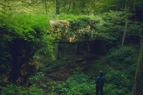
Making a visit to the Pomona Natural Bridge after a hard rain is a favorite of waterfall chasers and will also give you a great visual for how this formation was created. Historic pictures from when this trail was built in the 1930’s show the clean and smooth arch devoid of any flora. Back then, the Murphysboro to Pomona narrow gauge rail line would make special stops here at the arch on Sundays to let visitors explore the area and nearby Salt Peter Cave (now called the Shawnee Amphitheater). Now nearly encapsulated by sedges, ferns, and mosses, Pomona Natural Bridge has been in the process of steadily being reclaimed by nature over the last 100 years. An 8 foot wide path meanders through all of the vegetation over the entire length of the arch, which is where we’re headed next.

To get to the top of the arch from the overlook, follow the trail over to the far end of the cliffs. Here, a series of rock ledges used as stairs connect the hillside to the north end of the span. As these ledges can be extremely slippery and hazardous when wet, it’s best to take your time going down. Once on top of this natural bridge, you really get a sense of just how enormous the entire structure is. At over 90 feet long, it’s just a dozen feet shorter than the behemoth, Bell Smith Springs Natural Bridge. Rising 30 feet over the canyon floor, the arch slopes slightly downward to 20 feet in height as you walk towards the opposite end. The shorter end of the Pomona Natural Bridge connects to the main trail and a stone staircase that takes visitors down under the structure.

Running parallel to the staircase and coursing through several chutes in the canyon wall is the waterfall responsible for creating the Pomona Natural Bridge. Originally believed to be a large cave overhang, this arch was created by the steadily eroding force of this creek. Fed by a natural spring, the waterfalls accumulate into gorgeous pools of turquoise blue water as it flows under the arch and into the much larger Cedar Creek. Emptying into the much larger Big Muddy River and Worthens Bayou, this is where the U.S. Forest and C.C.C. ran the first successful operation to reintroduce wild beavers into Southern Illinois. Going deeper into the canyon, past the arch, you’ll encounter several more caves and cliff overhangs destined to become arches in another hundred thousand years. Though this entire loop takes less than an hour to complete, it will hopefully make a lasting memory and keep the spirit of the area alive for generations to come.

Up next, we’ll head another 45 minutes north to the outer fringes of the Shawnee National Forest to visit something near and dear to my heart. Southern Illinois is brimming with prehistoric cultural sites from mounds, to stone forts, and rock art sites. Piney Creek Ravine State Natural Area is known as having the largest collection of prehistoric petroglyphs and pictographs in the entire state of Illinois. Strewn across a 100 foot long cliff wall, this priceless cultural site is commonly visited by university groups as well as amateur enthusiasts alike. Stay tuned as we hike the 2 mile long loop to explore this amazing treasure and as always, see y’all on the trails!
Sources;
"The Civilian Conservation Corps in Southern Illinois" by Kay Rippelmeyer


0 comments