

As the states largest natural bridge, Rockbridge Natural Bridge is one of the many natural wonders of Hockings County, Ohio. This arch stretches over 100 feet long and 10 to 20 feet wide over an expansive rock shelter with a wet weather waterfall, which can usually be seen streaming through the heart of it. Established in 1978, the Rockbridge State Nature Preserve protects not just this natural arch, but several other rock shelters and cliff overhangs known to have been used by prehistoric Native Americans over 10,000 years ago. Navigating this nature preserve is easy along its 2 miles of rugged hiking trails which traverse in and out of several deep ravines where the rock formations are located.
Connector Trail | 0.5 Mile
Natural Bridge Trail | 1 Mile
Rock Shelter Trail | 0.75 Mile
Rockbridge State Nature Preserve Trail Map | Hocking Hills
Rockbridge State Nature Preserve Location | Google Maps
Arriving shortly after sunrise to kick off my Hocking Hills State Park adventure, I pulled off U.S. Route 33 onto Dalton Rd and followed it a short distance to the dead end, right beside Heart of the Country Cabins. Make sure to park on the left side of the large gravel lot, facing the expansive pasture. The opposite side of the road is private property and your car might not be there when you return from your hike.
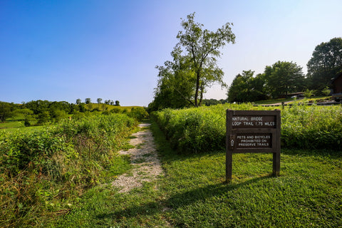
To access Rockbridge, visitors have to travel 0.5 miles down the Connector Trail to reach the main nature preserve. This gravel path cuts through a pollinator habitat meadow and a series of boardwalks as it meanders into a deep ravine out of sight from the parking area.

The sign at the entrance mentions a 1.75 mile loop, but the trail here is built into a series of interloping figure eights with two distinct areas. After climbing a steep embankment, using the tiny tree whips along the edge of the trail to pull ourselves over the burled tree roots crowding the path, we reached the first of two trail junctions.

To see the arch, stay to the LEFT at both of these junctions. The trail markers here are vague so without any prior knowledge of the area, those that turn right will inadvertently start their journey along the Rock Shelter Trail. It pays dividends to check out a trail map of the area you’re planning to visit before arriving.

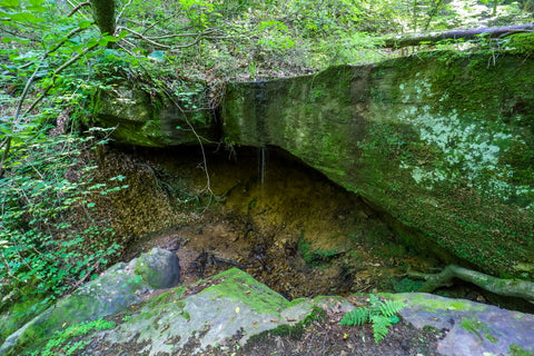
Approximately 0.18 miles after the first trail junction is the second one. Again stay LEFT. This time a small blue arrow on a wooden beam points the way to the arch. Just around a small bend from here you’ll begin to descend into the cove containing Rockbridge. Before even noticing the arch, most peoples eyes are drawn to the large gaping hole in the ground that makes up the sky light looking down into the rock shelter below. On the far side of this 40 foot drop is the slender 100 foot long natural bridge.

What makes this officially a natural bridge, as opposed to an arch, is the fact that a mostly wet weather stream runs through the heart of it. During periods of heavy rain, this small stream transforms into a gorgeous waterfall known as Rockbridge Falls. The arch is wide enough to safely walk across and offers a unique perspective of the wooded ravine. Before part of its ceiling caved in along a natural joint plane, Rockbridge spent much of its earlier life as a shallow cave. Ohio is known for its deposits of soft Mississippian Black Hand sandstone and many of its 12 known natural bridges are composed of it.

A trail just past Rockbridge travels down underneath the arch and into a corner of the rock shelter below. Walking within the cavern-like passage is prohibited due to an ongoing effort to revitalize the area. Due to the erosive forces of the stream falling overhead and decades of overuse, the areas delicate plant life and ecosystem are getting a chance to bounce back. Part of the closure is also due to the fact that during winter, this area can become dangerous as large sheets of icycles form all along the edge of the cliff and arch to put on a magnificent winter display. Another short trail next to the rock shelter will take you to the creek bed far below Rockbridge if you’re so inclined.

To head back to the parking area, I decided to take the scenic loop towards the Rock Shelter Trail by turning LEFT at the fork. The fastest way to exit would be to just head straight past both trail junctions without making any turns. At this point, a short climb up a steep embankment leads up to a third trail junction and the start of the 0.75 mile Rock Shelter Loop.

By the amount of spider webs clogging up the path, it’s safe to assume that this trail sees few visitors. One of the most memorable moments on the trail was when I came face to face with a juicy looking Marbled Orb Weaver the size of a silver dollar, on a web nearly as big as my body. These harmless spiders are known for making elaborately intricate webs almost overnight.
After slowly moving the web aside and gently setting the spider down, I made the trek down into the rocky ravine where the rock shelter is located. It’s a shame that most people tend to skip this trail as our path meandered through gorgeous wildflower strewn hillsides covered in dense mats of towering ferns, purple blooming spiderworts, and bright red royal catchflys that would give any visitor pause. All the while the trickling sound of water played in the background giving the whole experience a serene natural beauty. It feels worlds away from the congested area surrounding Rockbridge.

Once the trail hits the bottom of the ravine and you see the creek, veer left off the trail and walk towards the edge of the creek bed as it plummets down 12 feet. The rock shelter is located at the bottom of the drop, below the trickling creek. I almost walked right past it as the entrance is hidden out of sight behind a large boulder pile. Maneuvering over the slick rocks, I found a small path down that required a quick scramble to reach the entrance via the rushing creek. After squeezing through the tight passage of boulders blocking the entrance, you’ll come face to face with a pleasantly small waterfall streaming over the roof of this hidden gem. After taking a quick tour of the rock shelter and ravine, just continue along the rest of the 0.35 mile loop until it connects back with the Connector Trail to the gravel parking lot.

Up next, well be traveling 10 miles south to visit the first area of our Hocking Hills State Park trip. Cantwell Cliffs is known for its rugged trail system which travels through deep valleys, high cliffs, and expansive rock shelters. I’m excited to begin exploring this legendary hiking destination so stay tuned for our upcoming article and until next time, see y’all on the trails!


0 comments