

Google Maps | DeSoto Falls Picnic Area
Hiking Trails Map | DeSoto Falls Picnic Area
DeSoto Falls was the last stop on our unexpected journey, exploring the natural beauty of Northeast Alabama. There are dozens of waterfalls in this region ranging from High Falls Park and Arch, Little River Falls, and Noccalua Falls. If you can only see one of them, I highly recommend you chose this one. Although it is considered a part of the much larger DeSoto State Park, DeSoto Falls is actually located 7 miles to the north of it, in a small hamlet of the West Fork Little River.

There are two unique ways to experience visiting the falls, with the first being a stop at the picnic area to view the upper falls and climb down onto the cliffs to the falls overlook. Located at the end of Highway 613 as it turns into DeSoto Falls Road, there is a small $4 fee per car to enter the picnic area during the busy summer season. Here you’ll find facilities, a boathouse offering kayak rentals, and a small trail leading to an overlook right above the falls. Looking out over the top of the falls near the parking lot, the first thing you’ll notice is the dam thats built just above the cliffs precipice. DeSoto Falls was once the site of the first hydroelectric dam built in north Alabama during 1925.

Designed to harness the force of the falls, the electricity generated here powered the towns of Fort Payne, Mentone, Valley Head, Collinsville, and Menlo, Georgia. Homes in these areas were granted the privilege of having electricity from sun down to midnight. As the story goes, as electrical appliances such as irons began to become popular, the towns were granted an extra allowance of electricity during the day so that women could do their ironing for the week. A byproduct of building the 20 foot dam was the creation of DeSoto State Park Lake. Once regularly stocked with bass and bream, this was the go to spot to do a little sport fishing, go swimming, or spend the day out on the boat. Today, visitors can still swim and even rent a kayak to take out on the lake.

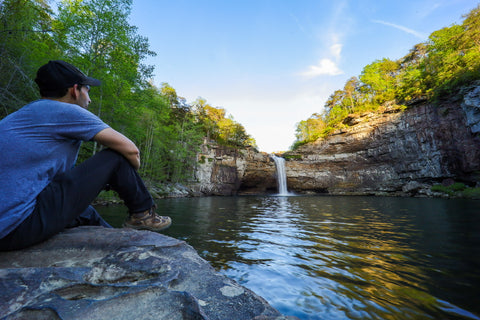
The Overlook Trail is nothing more than a short paved path leading from the parking lot to the cliffs overlooking the top of the falls. After climbing down the double flight of steps, you’ll reach the first platform overlooking the river just as it tumbles over the cliff into the canyon below. If you have little ones keep a close eye on them as the railing here is big enough for small children to squeeze through. Part of the guard railing is open for those with an adventurous spirit to walk onto the cliffs just on the back end of the falls below the dam. Standing here amid the torrent of water roaring past us, one can literally feel the force that once powered this entire region. Looking up above the rapids, you get a different view of the dam with its steel walls holding back the waters of DeSoto S.P. Lake.

To the right of this area is a narrow path leading down a short flight of steps to the Canyon Overlook. This is the view that everyone drives far and wide to see. From this vantage point, one gets an unobstructed view of the canyon and small lake down below. Caves and small rock shelters line the bottom of the canyon walls, created over millions of years by the splash back from the falls. On the west end of the canyon is a flat square area where the generator responsible for creating power from the falls was once located. Scanning the dense forest surrounding the lakeshore, I spot a group of hikers waving up at us and I enthusiastically return the gesture. This is where we are headed to next!

Overlook Trail | 0.45 Miles
DeSoto Falls has roughly 1.5 miles of hiking trails, all situated in the canyon below the falls. Although they are only short out and back trails, they pack some impressive scenery and travel through enough challenging terrain to make it seem like a much longer trek. To reach the trails, we leave the picnic area and travel 1 mile back down Highway 613 to the large parking lot just off the side of the road. Its hard to miss and chances are you passed it on your way to the falls. Trail maps can be found at the picnic area as well as posted to the trailhead. The Overlook Trail (Blue) is a 0.45 mile, out and back, that navigates the upper ridges of the canyon to a cliff overlooking the front of DeSoto Falls. This moderate trail is the most accessible for those just wanting to get a picture and take a moderately easy stroll through the woods.

River Trail | 0.70 Mile
Fondly referred to by its blaze colors, the River Trail (Pink) and the Bluff Trail (Pink\White), are the two most popular trails here and the ones we set out to explore. The River Trail is the main point of access to the basin below DeSoto Falls, while the Bluff Trail acts as a secondary spur from it, looping through some interesting rock formations including a large rock shelter nicknamed, the Ice Box. Heading out from the trailhead and into the forest, you immediately take a sharp right turn to merge onto the pink trail down a few steep switchbacks. If you miss the turn, you’ll end up on the Blue Trail hiking straight to the falls overlook.

While the River Trail clocks in at just a little less than a mile, this out and back is considered strenuous and even technical at points due to its various rock scrambles along the way. As we worked our way down from the parking lot, the trail enters a small canyon flanked by towering cliffs and large stacked boulders. The scenery is gorgeous and not what I had expected from what I thought Alabama’s mostly flat landscape would have. With large stands of blooming rhododendrons and magnolias, wet-weather waterfalls, sandstone cliffs and rock shelters, this landscape resembles most of what I have encountered in north Georgia, Tennessee, and Kentucky.

As we passed through the heart of this canyon we encountered a group of N.S.S. (National Speleological Society) members practicing their caving skills by rappelling down the cliffs. A mix matched group from different grottos had gathered here for the day to rappel down the face of DeSoto Falls. This was their dry run, choosing to practice on the smaller 20 foot cliffs before attempting the 104 foot plunge. While I jokingly declined to take part in the exercise, it was fun meeting a few of the members and chatting about some of the caving in the area. Making our way out of the canyon, the trail begins descending down a boulder strewn hillside where it meets the Bluff Trail.

Bluff Trail | 0.30 Miles
We merge left onto the Bluff Trail spur which cuts along the base of the cliffs for a short 0.30 miles, before reconnecting with the River Trail. Just a short distance from the junction, I clear past a bend in the trail and come face to face with a towering rock shelter. This is the Ice Box. The entire area surrounding DeSoto Falls is steeped in local lore surrounding all of the various peoples that have either lived here or explored the area. Native Americans, as far back as the Woodland Period, once inhabited these bluffs and even went so far as to build forts here. Once part of tribal lands belonging to the Cherokee, they often visited the falls considering it a sacred place. Its beauty may have even inspired the famed Cherokee scholar Sequoyah, who lived in nearby Wills Town, in his creation of the Cherokee Alphabet.

Hernando de Sotos Expedition in 1538 is believed to have wandered close to the falls area on their journey from Florida through the foothills of the Appalachian Mountain. Legend has it that artifacts from that expedition were found near the falls. Others claim the items belong to an ancient fort built beneath the falls, during an even earlier European expedition led by Welsh Prince Madoc. According to folklore, the Welsh explorers landed in Mobile Bay in 1170 and traveled north through the area surrounding Lookout Mountain.

Just past the rock shelter are a few wet weather waterfalls streaming down from the bluffs above us. Maneuvering over the boulder strewn trail as we work our way from the Bluff Trail back onto the River Trail is challenging. Following along the banks of the West Fork Little River, with its myriad of tiny waterfalls and rapids, reminds me a lot of hiking in the Great Smoky Mountains.

Blooming magnolias and Carolina allspice line our entire path, filling the air with their sweet perfume. Carolina Allspice in particular has a fun bit of history tied to its use here in the south. Nicknamed the “booby bush”, it was customary for women to crush the flowers and place them in their cleavage, with bodily warmth releasing the flowers scent over the course of the day.

Hiking the river trail is not without its own challenges. There are massive boulders the size of small cars smack in the middle of the trail that have to be climbed over or squeezed through in order to pass. Even walking can be a drag as the path is mostly deep beige sand, like what you would find on most beaches. Nevertheless, we clear the thicket surrounding the river and emerge on the banks of the falls basin. Words cannot describe the immense beauty of it all.The scene is simply stunning. Better yet, we arrive just in time to watch the N.S.S. team begin their rappel down the face of the falls. As the weather continues to warm up into mid summer, this small lake will be packed with visitors enjoy an afternoon swim in its cool waters.

While Alabama might not be on the top of everyones list for hiking destinations, its proving to be one of my all time favorite places to visit. It really does pay to not always judge a book by its cover and to simply surrender yourself to the experience and live in the moment. Leaving the falls basin, we head back on the River Trail to reach our starting point in the parking lot. I made sure to take plenty of mental pictures, breath the perfume filled air deeply, and let my hands wander carelessly over every boulder we encountered. This might be the end of our time here in Alabama, but I’ll be back.
Drop us a comment down below and share your experience of DeSoto Falls! Up next we will be heading just across the state line into Georgia to explore one of its most iconic state parks, Cloudland Canyon State Park. This massive canyon is tucked into a tiny corner of Lookout Mountain and is famous for its steep cliffs and majestic waterfalls. Stay tuned for those upcoming articles and until next time, see ya’ll on the trails!


4 comments
Can you swim at all the falls
This is a fantastic tvelogie of Little River and zDrsoto State Park, and it definitely makes me want to go. Thank-you. It is worth a commission.
Hi Lauren!
I did see that you can rent kayaks, but I didn’t know you could paddle all the way to the West Fork of The Little River! I figured you had to stay on the lake within sight of the dam. I’ll have to keep that in mind for a future trip there and to visit more of DeSoto State Park. Thanks for adding that recommendation to the page!!!
Just a quick mention, if you didn’t already when you visited you need to kayak upriver from the dam towards Mentone. This is the West Fork of Little River, go out of the park. Great flatwater section, goes about 2 miles until you come to a arch bridge spanning the river at your turn around point. Mountain Laurels, Rhododendrons, Sourwoods abound.