

Sam Knob Trail | 2.5 Mile Out & Back
Sam Knob Trail Map | Alltrails
Sam Knob Trailhead Location | Google Maps
The Black Balsam Knob Area is one of the most visited portions of the southern terminus of the Blue Ridge Parkway. Reached via Forest Service Rd 816 near milepost 420 of the parkway, it’s easy to find as its location is halfway in between Devils Courthouse and Graveyard Fields. Containing vault toilets, an advisory board, and ample parking spaces for a half dozen other trailheads in the Great Balsam Mountain range, you can make an entire day of visiting this scenic area without having to pack things up and move your car. From here one can access paths north into the Shining Rock Wilderness along the Art Loeb Trail, east to Graveyard Fields, or south towards Little Sam Knob, Flat Laurel Creek Valley, Wildcat Falls, Chestnut Bald, Silvermine Bald, and Devils Courthouse.

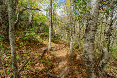
Having just finished up a scenic loop atop the Art Loeb Trail from Black Balsam Knob to Ivestor Gap, I headed over to the Sam Knob Trailhead located behind some hip high brush near the restrooms to begin my journey. The first 0.35 miles of this trail travels through a second generation mixed evergreen and deciduous forest that’s mostly level and easy to navigate. It’s once you exit the forest and take a look out at the expansive meadow surrounding Sam Knob, that one starts to recognize just how special this area truly is. The solitary peak of Sam Knob sits at one end of this grass meadow surrounded by the curving range containing Black Balsam Knob, Silvermine Bald, and Chestnut Bald to the south, and a wide valley created by the West Fork Pigeon River to the north.

Much like the nearby Ivestor Gap Trail, the trail to Sam Knob is part of a gravel road that was once used by local logging companies in the early part of the 20th century. Mostly deforested except for the steepest ridges, the area saw its wildest transformation after two separate fires raged through the area burning thousands of acres. During the early days of logging, timber men had zero interest in the small tiny branches, known as slash, that were leftover after taking down a massive tree. Because of this, large piles of slash accumulated over hundreds of acres surrounding these operations. In 1925, one of these piles of slash would be ignited into the first of two epic fires. Burning intensely for three days, the fire charred the landscape from the ridges of Little Sam Knob all the way to Cold Mountain. It wouldn’t be until 1942, with the second fire ignited by a narrow gauge locomotive, that Congress would legislate the logging companies into clearing up slash to avoid such incidents in the future.

Known for its picturesque wildflower displays each spring, its also a perfect place to catch a glance of some dramatic fall foliage. Getting down into the meadow, we step onto a wooden boardwalk that extends across a marshy area before walking out into the field. Walking amidst the grasses swaying in the wind while catching a glimpse of bees pollinating stands of purple asters disarms you to the fact that a strenuous ascent lies up ahead. Standing guard over this hidden valley is Sam Knob. From this vantage point looking up at Sam Knob, you can easily see the indentation near the summit, creating its distinctive double peaks. Hiding in the shadows behind todays main objective, is a sub peak not much bigger than a large hill named Little Sam Knob.

As we reach the base of Sam Knob, the trail abruptly ends at a “T” intersection near the 0.75 mile mark. Turning left would put you on a 1 mile spur trail connecting this to the Flat Laurel Creek Trail. From there, hikers have the option of undertaking either a short 3.7 mile loop south, back to the Black Balsam Trailhead or an all day 9 mile excursion from Flat Laurel Creek to Wildcat Falls and back along Little Sam’s Knob Trail. Both of these loops would make a great addition to this hike, but todays itinerary has us solely focused on summiting Sam Knob. To reach our objective, I turn RIGHT at this junction and disappear into the tunnel of gnarled trees up ahead. Reminding me a lot of the weathered rhododendrons surrounding Craggy Gardens, the trees here are bent and misshapen due to the extreme weather experienced in this region.
Unlike the northern flank of Little Sam’s Knob which was reforested with red spruce to avoid severe erosion, Sam Knob was left to reforest itself at the will of Mother Nature. Not a single stretch of even surface exists on this leg of the journey. In areas where the path seems somewhat level, roots the size of a mans torso rise up to impede the way. You have to lift your knees high up into the air, aiming for any bare spot not choked with roots on the step down, almost as if you were running an obstacle course. Then there’s the mud to contend with. Created by run off traveling down the mountain, it presents a challenging if not comical spectacle as one attempts to climb the switchbacks towards the first staircase.

Leaving the understory of the lower forest canopy behind, we get our first glimpse of the scenery that’s to come up ahead. Traveling in a clockwise motion, the trail spirals upward from the front of Sam Knobs first peak, towards the center of the gap in front of the second peak. The only thing keeping you from tumbling over the side of this mountain are the colorful thickets of blazing red blueberries, baby mountain laurel trees, and evergreen rhododendrons crowding the outer edge of the trail. While admiring some of the blossoms of dried wildflowers along my hike, I happened to catch a glance of a spicebush swallowtail butterfly feeding on a stem of its host plant, the spicebush. As soon as I adjusted my gaze, I realized there were at least a dozen of them fluttering through the grasses.

Reaching the center of the gap I found the trail badly eroded and requiring a tad bit of scrambling over some knee deep trenches, where solid ground once existed. There are several small clearings with primitive camping spots and two well traveled paths going in opposite directions to each of the peaks. Turning RIGHT (South), I walked about 5 yards to find another path darting LEFT up to the true 6,050 ft summit of Sam Knob. Much like Craggy Dome, the summit is choked with thickets and brush that obstruct the views. On a cloudy day like today the weather ceiling is almost low enough at this spot to reach my arms up and touch some passing clouds. Despite a lack of views from this vantage point, its well worth the few extra steps just to say you climb the true summit. Walking back onto the southbound path, we exit out of a thicket into a wide open expanse atop the first of the two bald peaks atop Sam Knob.

The first overlook which is lovingly referred to as “the white rock”, faces in the direction from which we entered the Sam Knob Trailhead with the gorgeous meadow. The name comes from the fact that the shining, white quartz boulders are unmistakeable and hard to miss. If you were to hike the Art Loeb Trail to Shining Rock, this is exactly the same outcropping you would encounter at the heart of the Shining Rock Wilderness. From the top of this rock, the views of the southern band of the Great Balsam Mountains encircling Sam Knob just explode. The tallest hum straight ahead and slightly to the left is Chestnut Bald (5,975’), the tiny hill immediately to the right is Devils Courthouse (5,720’), and the tall peak off in the distance to the far right is Mount Hardy (6,122’). In the valley below us are the two branches that unite to create Flat Laurel Creek. Poking out of the ground right behind the creek is the half forested slope of Little Sam’s Knob.

After admiring this view, I walked back on down to the gap and up tp the northern peak overlook. What I saw completely blew my mind away. If Linville Gorge is the Grand Canyon of the east, then the West Fork Pigeon River is its baby brother. This has to be one of the most dramatic vistas in the southern terminus of the Blue Ridge Parkway. Blazing a path through the heart of this valley just out of sight is Lake Logan Road (SR 215). Once part of a narrow gauge railroad, this road leads to direct access of three major waterfalls in the area; Wildcat Falls, Sunburst Falls, and Walsh Hollow Falls. The peaks on the opposite side of this road belong to the Middle Prong Wilderness. Known as the twin sibling of The Shining Rock Wilderness, the 7,900 acres of this preserve within the Pisgah National Forest is known for its remoteness amid crystal clear mountain streams and high elevation peaks.

Heading back down off Sam Knob, I’ll be packing up my gear and heading over across the ridge to climb Devils Courthouse. As one of the most iconic landmarks on the Blue Ridge Parkway, the overlook at Devils Courthouse and a climb to its rocky summit is a must for hikers of all ages. Steeped in Native American lore, this peak has incredible views of the surrounding mountain ridges and also serves as a protect home to the endangered Peregrine Falcon. You won’t want to miss this fun hike so stay tuned and as always, see y’all on the trails!


0 comments