

Hidden in plain sight within one of the largest parks in the city of Louisville, the Cherokee Park Double Arch is one of the many hidden gems of the Olmsted Parks Conservancy. While Kentucky is known for having the largest concentration of arches outside of Utah, most are concentrated on the eastern half of the state. Being the only documented arch in all of Jefferson County, this double arch is known for being deceptively small and hard to find, often blending in with its surroundings. Searching out its hidden location among the deep ravines and rolling valleys of this park is akin to finding a needle in a haystack, but one I was willing to undertake on a beautiful spring afternoon in one of my favorite parks.
Map | Cherokee Park, Olmstead Parks Conservancy
Cherokee Park is a 409 acre municipal park located in the heart of Louisville's Highlands neighborhood. It was designed in 1891 by Frederick Law Olmsted, the father of landscape architecture, along with 18 of Louisville’s most prestigious parks. Have you heard of New York City’s Central Park? He designed that shortly before arriving in Louisville to work on the city's ambitious park system. Cherokee Parks main feature is Beargrass Creek, with its watershed running through most of the park and is crossed by numerous bridges. Getting around is easy thanks to the 2.4 mile Scenic Loop. Despite the parks natural look, every aspect of it was man-made to resemble an idillic pastoral setting of rolling hills, open meadows, and woodlands.

There are several tools out there for discovering interesting and rare rock formations throughout the country. One of my favorite and preferred ways to find these gems is through the Natural Arch and Bridge Society’s search portal. NABS, as its commonly referred to, is an all volunteer non profit society supporting the study, appreciation, and preservation of natural arches and bridges. Formed in 1988, its roster of international members includes scientists, educators, and authors who are leading the study of natural arches. Thankfully, membership into this organization is open to any person with an enthusiastic desire to visit, study, photograph, write about, or preserve natural arches.

Membership grants you access to join the World Arch Database, which collects information of arches throughout the world. In conjunction with another Kentucky specific database, I was able to pinpoint the relative location of where the arch should be, near one of its many entrances. As the city of Louisville expanded around the park, developers generously donated land to add onto the park, in exchange for having their own access roads. The numerous entrances have made navigating the park notoriously confusing to out of town visitors.

Parking my car near the Bonnycastle entrance at the intersection of Cherokee Rd and Dingle Rd, I began my journey by walking downhill towards the Scenic Loop. Cherokee Park has a wide network of dirt hiking and biking trails spread throughout, but this trek requires using neither. Looking to the steep limestone ravines for clues, I initially jumped onto one of the nearby trails in search of the arch. After wandering up and down wildflower covered paths for nearly an hour, I decided to take the paved Scenic Loop back to where I first began and start over. Thats when I had my revelation.

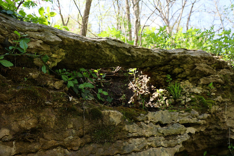
Near the hairpin turn the Scenic Loop takes, away from Barret Hill Rd, is a wide lawn with a park bench. Walking along the edge of the lawn, scanning the limestone cliff, I finally spotted the Cherokee Park Double Arch. I initially thought this arch would be large from several pictures I found online. Turns out the whole formation is a mere 2 feet tall and a little less wide.

Its shape was created by a small sinkhole penetrating through the top and bottom of the hillside, leaving behind a hollow cylinder. At some point, the center of the limestone ledge eroded to create an arch opening, gaining access to the hollow cylinder, thus creating a double arch. Not the most scientific explanation, but I think you get the point.

Its a bit difficult to get a full view of the double arch from looking at it straight ahead. To get a better vantage point I walked up the hillside to the top of the ledge. From up here, you can view straight down through the heart of the arch. Walking back down to my original spot, I played down flat near the bottom arch, looking out for any poison ivy beforehand. From this perspective down low, one can definitely make out both arch openings.
Being used to standing in awe of spacious and monumental arches, it was a real change for me to have to appreciate something as fragile and minute as Cherokee Park Double Arch. Even more so it was quite nice to not have to drive countless hours to enjoy a natural arch. If you live in Louisville, take an afternoon stroll through Cherokee Park and pay a visit to this hidden gem so it does not become completely lost to time. Until next time, see y’all on the trails!


2 comments
Hey Norman, I have taken many of those same excursions in Cherokee Park with camera in hand! You’re very welcome and thanks for stopping by!
been in cherokee park on very many excursions with camera in hand, notebook in the other and after realizing this park is unique, as Olmstead had planned, in many ways, as are others in this city, set off to locate said arch. THANKS – this is a really cool, vey well hidden gem. I had always thought there was one near the limetone “cliffs” area in/around BIG ROCK, but never located one. But always enjoy the workout Cherokee Park gives me w/all of its ups-and-downs. Agan, THANKS so much for post/photo