

No waterfall chasing roadtrip through Western North Carolina would be complete without a stop to see White Owl Falls, D.E.W. Falls, & Johns Jump Falls. The Thompson River Basin of the Nantahala National Forest contains some of the states most plentiful and tallest waterfalls anywhere. Located along North Carolina Highway 281 between the town of Sapphire and the South Carolina state line, these beauties are easily accessible from gravel pullouts just off the highway. Residing only a quarter mile from one another and with their own dedicated trailheads, these off-trail waterfalls can be grouped together for a quick tour of the area.
White Owl Falls | 0.21 Miles
White Owl Falls Trailhead | Google Maps
D.E.W. Falls | 0.16 Miles
D.E.W. Falls Trailhead| Google Maps
Johns Jump Falls | 0.10 Miles
Johns Jump Falls Trailhead | Google Maps
Before beginning, a word of CAUTION: Parts of this hike include UNMARKED TRAILS, not registered on any official map of The Nantahala National Forest. This hike includes scrambling over exposed cliffs and rock ledges that have resulted in deaths and injuries. Do not venture out alone. Use common sense and do not attempt anything that would put yourself or others at risk or harms way. This is NOT meant to be an instructional article, but a recollection of my own journey. The Nantahala National Forest and Western North Carolina are home to several species of venomous snakes as well as black bears. Be Bear Aware. Do your own research before going out and attempting any hike!

I have taken several road trips down through North Carolina Highway 281 as it is the entry point into Gorges State Park, travels past Whitewater Falls (the largest waterfall east of the Mississippi), and is also the gateway into South Carolinas Joccasse Gorge. Somehow or another throughout the years I had missed the fact that it is also the location of some of the most plentiful off-trail waterfall scouting in the region. The Thompson River Basin which feeds White Owl Falls, is one of the wildest and least explored in the area. Both D.E.W. Falls and Johns Jump Falls lie on Mill Creek, which is a major feeder tributary to the Thompson River as well. While a lot of these waterfalls require grueling day long bushwhacks through the forest, White Owl Falls, DEW Falls, and Johns Jump Falls are some of the easiest to reach and can even be heard from the roadway they are so close. All of these waterfalls and trails are visible on the current version of Gaia GPS App and it is also recommended that anyone visiting these sites should download the GPS Coordinates for all three waterfalls as well.

Trailhead for White Owl Falls just to the left of highway barrier.
White Owl Falls (N35.07652, W-82.99696)
The first of these waterfalls we’re going to see today is one of the more popular ones, White Owl Falls. We’ll start off our trip by heading south on NC-281 from the small town of Sapphire and drive past the Grassy Ridge entrance of Gorges State Park nearly 3.7 miles. At which point I spotted a fairly large gravel pullout on the right side of the highway, just past Brewer Rd, only a short walk from the trailhead. A note on this: White Owl Falls is the only one of these three waterfalls that does not have a parking area adjacent to the trailhead. This means visitors will have to cross NC-281 and walk down the side of this very busy highway roughly 50 yards to the trailhead. There is a wide enough grassy shoulder on the oncoming traffic side that I used to walk down heading south and felt fairly safe doing so.

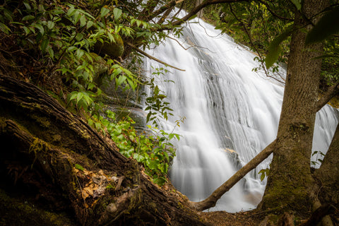
White Owl Falls through the trees.
 A wide shot of White Owl Falls and the surrounding area.
Roughly 50 yards from where I parked, I spotted the red ribbon tied to a tree branch adjacent to a power pole and a wide path indicating the trailhead to White Owl Falls. The well worn path leads down a rocky embankment right beside a runoff drainage. Once we scrambled our way down, the trail darts off to the RIGHT, more or less following the highway overhead. As of recently, the power company cleared several sections of trees to install new power lines, almost completely destroying the trail to White Owl Falls. Despite all of the downed trees and brush we were still able to discern the trail and pick up the right path wherever we saw the red ribbons.

White Owl Falls after a recent storm and some forest clearing dumped debris over the falls.
At a little less than a 0.25 mile, we walked our way up to a small ledge where we could see right over the top of White Owl Falls. By most standards this is a small waterfall at 15 ft high, but by gosh is it gorgeous. Rich Stevenson, one of the most renowned waterfall chasers in North Carolina, considers it one of his favorites. There is a lot of debris hanging over the waterfall itself and downstream which make it difficult to get a clear view of. I walked across the river hoping to get a clear frontal view of the falls, but found the best view was right from the trailside of the stream. Nonetheless it is still breathtaking.

Gated trailhead for D.E.W. Falls just off NC-218.
D.E.W. Falls (N35.06850, W-83.00942)
Next on our list is quite possibly my favorite of the entire afternoon, D.E.W. Falls. The initials on this waterfalls name is for Dorothy Ehrlich Walker, who died in an automobile accident during her senior year at Hammond School in South Carolina. This waterfall lies along Mill Creek, which is a major tributary of the Thomson River. After finishing our visit at White Owl Falls, we got in our car and drove roughly 1 mile south on NC-281 till we saw a gated Forest Service Rd with a small pull off in front. This is the trailhead for D.E.W. Falls. From what I’ve read, this was once a fairly popular recreation spot with several camping areas and picnic tables maintained by the Forest Service until it fell under disuse and was decommissioned indefinitely.

Front and center view of D.E.W. Falls and the surrounding cove.
 Standing in front of D.E.W. Falls.
This is another short and easy to follow trail. Just walk past the gate and walk along the main wide trail here into the woods for maybe 30 yards until you see another small trail on your LEFT hand side. This is the entrance to D.E.W. Falls. It’ll appear just after walking up the craggy hill and entering under the rhododendron tunnel. Following this trail as it winds to the RIGHT, we immediately heard the roar of the falls as it came into view through the brush. The trail ends at a 6 ft high ledge and one simply has to scramble down into the creek basin below.

One of the many cascades downstream from D.E.W. Falls.
Pictures simply don’t do this waterfall any justice. D.E.W. Falls 10 ft drop cascades into a serene and idilic cove surrounded by lush tropical vegetation and feels a world apart from anywhere else. It is hard to tell from pictures, but the cove itself has a shallow 2,000 sq. ft natural pool in the heart of it surrounded by sand bars. It leaves little to wonder why this was such a popular camping spot for years. One of the more interesting aspects of this waterfall are the rocks lining the creek bed which have been eroded into horizontal channels. If you follow the water downstream from D.E.W. Falls maybe 20 yards, you’ll find another small cascade streaming through this interesting rock formation.

John’s Jump Falls parking area and trailhead just off to the right.
Johns Jump Falls (N35.06784,W-83.00740)
The last waterfall on this list actually flows directly downstream from where we’re standing, Johns Jump Falls. To get there, we drove downhill a staggering 0.02 miles to a large gravel parking area that could accommodate 20 vehicles. One could easily just take the 5 minute walk down from D.E.W. Falls if need be, but why take the risk. You’ll immediately hear this waterfall once you step out of your car, it’s that close. The trailhead to Johns Jump Falls is located at the edge of a grassy area adjacent to the parking area. Unlike the hikes to the previous waterfalls, this 0.15 mile trail can be strenuous as the terrain is fairly steep.
First view you get of John’s Jump Falls as you approach from the trail.
With little to hold on to while traversing the badly eroded hillside, trekking poles can be very useful. The rhododendrons are also thick here, so wrestling to get through them is always fun. As soon one gets down the hill there is a small side trail that forks off to the RIGHT. This side trail ventures down to the lower cascades and boulder filled rapids of Mill Creek just south of Johns Jump Falls. It’s a fantastic area to explore and from my experience super photogenic. If you want to skip all of this just veer LEFT when you see this fork and continue straight on the main trail.

Hanging out at John’s Jump Falls.
Seeing the falls straight ahead, you’ll descend onto a gravel sand bar directly below the splash pool of the falls. At 25 ft high, Johns Jump Falls is still considered small in comparison to some of the monster waterfalls nearby, but again it is utterly beautiful and very photogenic. This cascading style waterfall is the most common shape found in the Joccassee Gorge watershed with its slightly narrow precipice and wide fanning body. I enjoy seeing the ripples of water bounce off every single protruding rock ledge. Personally I think it makes for a more compelling image than some of the taller chute style waterfalls. If you’re interested in seeing the top of the falls, another small side trail scrambles up the left side of the cliff for a closer look.

Bridge spanning over the top of Slippery Witch Falls.
Bonus: Slippery Witch Falls (N35.06942,W-83.01327)
I decided to throw in Slippery Witch Falls as a bonus because of its relative location to all three of the waterfalls in this article. As a matter of fact it is the first documented waterfall on Mill Creek just upstream from D.E.W. Falls. At 90 ft tall, it is the tallest on this tributary. There is a caveat to seeing this waterfall which is you can only see it from above. Slippery Witch Falls lies directly below a single lane bridge in an area that is slowly being parceled out to become a private community. There is a known trail that travels from the roadside down to the base of the falls, but up until recently it is on PRIVATE PROPERTY. With that being said, as the roadway to Slippery Witch Falls is located directly opposite the parking area for Johns Jump Falls, I found it to be a worthwhile stop.

View of Upper cascades of Slippery Witch Falls to the left of bridge.
 Slippery Witch Falls as it cascades under the bridge.
 Looking down at the 90 ft tall Slippery Witch Falls.
 The closest I managed to viewing the middle slide of Slippery Witch Falls.
Right before reaching the bridge spanning Slippery Witch Falls, there is a small pull-off where one can park. From the roadway, I was able to glance maybe halfway down the 90 ft tall height of this falls before it disappears from view. If you look on the opposite side of the bridge or even take the walk down under it, you can catch an unclose view at some of the upper cascades. It’s a shame that someone decided to put up a bridge over this magnificent waterfall and that now access is prohibited. Some things should always remain wild and free. Stay tuned for our upcoming article on our stop to see the tallest waterfall east of the Mississippi, Whitewater Falls. The mother of all waterfalls in the Joccassee Gorges Watershed is truly awe inspiring and something every nature lover should see. Only a short drive from these three other waterfalls on NC-218, Whitewater Falls can easily be reached by a short 0.25 mile trail in its own dedicated Scenic Area. Comeback next week and as always, see y’all on the trails!


0 comments