arrow-right cart chevron-down chevron-left chevron-right chevron-up close menu minus play plus search share user email pinterest facebook instagram snapchat tumblr twitter vimeo youtube subscribe dogecoin dwolla forbrugsforeningen litecoin amazon_payments american_express bitcoin cirrus discover fancy interac jcb master paypal stripe visa diners_club dankort maestro trash

Shopping Cart


Trail Guides

Silver Run Falls, The Quintessential Western North Carolina Waterfall, Nantahala National Forest

Guide to hiking silver run falls Nantahala National Forest North Carolina

Beautiful during any season, Silver Run Falls is among one of the most visited waterfalls in Western North Carolina. Located within the Nantahala National Forest just south of Cashiers, this waterfall can easily be reached via a short 0.16 mile trail off NC-107. At 25 ft tall, Silver Run Falls cascades into a tranquil pool surrounded by a small beach area that is frequented by locals during the summer months. This family friendly hike meanders through a wildflower filled cove, crosses a bridge spanning the headwaters of the Whitewater River, and ends at several observation points of this stunning waterfall.

Silver Run Falls | 0.16 Miles

Silver Run Falls Trailhead | Google Maps

Nantahala National Forest Map

 <p><span class="Apple-converted-space"> </span></p> <p> </p> <p>Right off the bat, the gravel trail enters the forest and cuts through an understory of rhododendrons and pines filled with blooming blueberries, mountain laurel, and all other kinds of wildflowers you might expect in early May. The musky scent of wet pine needles mixed with the sweet perfume of the laurels is what I associate most with hiking in the Appalachian Mountains. You’ll pass a small side trail to the left that leads off-trail to another waterfall most visitors are unaware exists, Upper Silver Run Falls. This 20 ft waterfall upstream from the main Silver Run Falls is beautiful in its own right, but requires a hefty hike and dicey vertical scramble to reach. HikingWNC has a great article on this waterfall and how to reach it for anyone interested.</p> <p style="text-align: center;"> <img src="https://cdn.shopify.com/s/files/1/0270/1760/9300/files/B044D4C2-8D7A-4FA5-B6C4-DCDEDD26CCCC_480x480.jpg?v=1684858083" alt="    Silver Run Falls Trailhead     There are many pull-outs along this highway that lead to dozens of little known trails in the Nantahala National Forest which end with magnificent mountain vistas or at jaw dropping waterfalls. If you see a random car parked on the side of the road here chances are they’re chasing waterfalls. For this particular hike, we drove 4 miles south of Cashiers until spotting the bright yellow Forest Service sign for Silver Run Falls. Google Maps has the trailhead in their directory so getting here was a breeze. Being early in the evening, we had the place all to ourselves which made it that much more special. At only 0.16 miles long, this trail has one of the best bangs for your buck for all of the scenery that gets packed into such a short duration.      Right off the bat, the gravel trail enters the forest and cuts through an understory of rhododendrons and pines filled with blooming blueberries, mountain laurel, and all other kinds of wildflowers you might expect in early May. The musky scent of wet pine needles mixed with the sweet perfume of the laurels is what I associate most with hiking in the Appalachian Mountains. You’ll pass a small side trail to the left that leads off-trail to another waterfall most visitors are unaware exists, Upper Silver Run Falls. This 20 ft waterfall upstream from the main Silver Run Falls is beautiful in its own right, but requires a hefty hike and dicey vertical scramble to reach. HikingWNC has a great article on this waterfall and how to reach it for anyone interested.     Crossing the Whitewater River     A few short minutes in and you’ll reach the walking bridge spanning the Whitewater River. Up until recently this crossing was merely a simple log, but for safety reasons the Forest Service constructed this sturdy bridge in its place. At this point upstream the Whitewater River is only a dozen feet wide, hinting little as to how enormous this river becomes by the time it reaches Whitewater Falls. Through the trees one can make out Silver Run Falls and hear its booming sound just a skip and a hop away. After crossing the bridge, the trail abruptly ends at a large rock outcropping on the shores of Silver Run Falls large wading pool.      Silver Run Falls      It may not be the tallest or largest waterfall in the Blue Ridge Mountains, but it sure is beautiful. The picturesque scene here screams Western North Carolina. Most people hangout on this outcropping and its the most photographed view of Silver Run Falls I’ve come across. Following the base of the cliff you can walk right up to the precipice of Silver Run Falls and feel the fine misty spray of its 25 ft drop.  Using some of the larger rocks, I made my way across the stream that drains Silver Run Creek into the Whitewater River and landed on the shore opposite the falls. In just a few short weeks this beach will be packed with swimmers bathing in the cool mountain stream and it’ll be impossible to find parking here.   Silver run falls Nantahala National Forest North Carolina hiking trail waterfalls" /></p>
Route taken from Gaia App.

Waterfall Chasing Mecca

Silver Run Falls is THE quintessential Western North Carolina waterfall that everyone needs to see. Accessible, short, and family friendly; what more could you want?! This waterfall was part of a long day trip that I combined with visits to see  Upper Whitewater Falls, Secret Falls, and White Owl, D.E.W., & Johns Jump Falls. With its access to the headwaters of the Whitewater River, NC-107 is one of the most heavily explored areas for waterfalls in Jackson County. The Whitewater River is one of the most spectacular rivers in the Southeastern US. In its 15-mile length, the river plummets over two of the region's tallest and most breathtaking waterfalls, through a rare narrow slot canyon, and over nearly a dozen smaller waterfalls.

<p><span class="Apple-converted-space"> </span></p> <p> </p> <p>Right off the bat, the gravel trail enters the forest and cuts through an understory of rhododendrons and pines filled with blooming blueberries, mountain laurel, and all other kinds of wildflowers you might expect in early May. The musky scent of wet pine needles mixed with the sweet perfume of the laurels is what I associate most with hiking in the Appalachian Mountains. You’ll pass a small side trail to the left that leads off-trail to another waterfall most visitors are unaware exists, Upper Silver Run Falls. This 20 ft waterfall upstream from the main Silver Run Falls is beautiful in its own right, but requires a hefty hike and dicey vertical scramble to reach. HikingWNC has a great article on this waterfall and how to reach it for anyone interested.</p> <p style="text-align: center;"> <img src="https://cdn.shopify.com/s/files/1/0270/1760/9300/files/B044D4C2-8D7A-4FA5-B6C4-DCDEDD26CCCC_480x480.jpg?v=1684858083" alt="    Silver Run Falls Trailhead     There are many pull-outs along this highway that lead to dozens of little known trails in the Nantahala National Forest which end with magnificent mountain vistas or at jaw dropping waterfalls. If you see a random car parked on the side of the road here chances are they’re chasing waterfalls. For this particular hike, we drove 4 miles south of Cashiers until spotting the bright yellow Forest Service sign for Silver Run Falls. Google Maps has the trailhead in their directory so getting here was a breeze. Being early in the evening, we had the place all to ourselves which made it that much more special. At only 0.16 miles long, this trail has one of the best bangs for your buck for all of the scenery that gets packed into such a short duration.      Right off the bat, the gravel trail enters the forest and cuts through an understory of rhododendrons and pines filled with blooming blueberries, mountain laurel, and all other kinds of wildflowers you might expect in early May. The musky scent of wet pine needles mixed with the sweet perfume of the laurels is what I associate most with hiking in the Appalachian Mountains. You’ll pass a small side trail to the left that leads off-trail to another waterfall most visitors are unaware exists, Upper Silver Run Falls. This 20 ft waterfall upstream from the main Silver Run Falls is beautiful in its own right, but requires a hefty hike and dicey vertical scramble to reach. HikingWNC has a great article on this waterfall and how to reach it for anyone interested.     Crossing the Whitewater River     A few short minutes in and you’ll reach the walking bridge spanning the Whitewater River. Up until recently this crossing was merely a simple log, but for safety reasons the Forest Service constructed this sturdy bridge in its place. At this point upstream the Whitewater River is only a dozen feet wide, hinting little as to how enormous this river becomes by the time it reaches Whitewater Falls. Through the trees one can make out Silver Run Falls and hear its booming sound just a skip and a hop away. After crossing the bridge, the trail abruptly ends at a large rock outcropping on the shores of Silver Run Falls large wading pool.      Silver Run Falls      It may not be the tallest or largest waterfall in the Blue Ridge Mountains, but it sure is beautiful. The picturesque scene here screams Western North Carolina. Most people hangout on this outcropping and its the most photographed view of Silver Run Falls I’ve come across. Following the base of the cliff you can walk right up to the precipice of Silver Run Falls and feel the fine misty spray of its 25 ft drop.  Using some of the larger rocks, I made my way across the stream that drains Silver Run Creek into the Whitewater River and landed on the shore opposite the falls. In just a few short weeks this beach will be packed with swimmers bathing in the cool mountain stream and it’ll be impossible to find parking here.   Silver run falls Nantahala National Forest North Carolina hiking trail waterfalls" /></p>
Trailhead for Silver Run Falls just off NC-107

<p><span class="Apple-converted-space"> </span></p> <p> </p> <p>Right off the bat, the gravel trail enters the forest and cuts through an understory of rhododendrons and pines filled with blooming blueberries, mountain laurel, and all other kinds of wildflowers you might expect in early May. The musky scent of wet pine needles mixed with the sweet perfume of the laurels is what I associate most with hiking in the Appalachian Mountains. You’ll pass a small side trail to the left that leads off-trail to another waterfall most visitors are unaware exists, Upper Silver Run Falls. This 20 ft waterfall upstream from the main Silver Run Falls is beautiful in its own right, but requires a hefty hike and dicey vertical scramble to reach. HikingWNC has a great article on this waterfall and how to reach it for anyone interested.</p> <p style="text-align: center;"> <img src="https://cdn.shopify.com/s/files/1/0270/1760/9300/files/B044D4C2-8D7A-4FA5-B6C4-DCDEDD26CCCC_480x480.jpg?v=1684858083" alt="    Silver Run Falls Trailhead     There are many pull-outs along this highway that lead to dozens of little known trails in the Nantahala National Forest which end with magnificent mountain vistas or at jaw dropping waterfalls. If you see a random car parked on the side of the road here chances are they’re chasing waterfalls. For this particular hike, we drove 4 miles south of Cashiers until spotting the bright yellow Forest Service sign for Silver Run Falls. Google Maps has the trailhead in their directory so getting here was a breeze. Being early in the evening, we had the place all to ourselves which made it that much more special. At only 0.16 miles long, this trail has one of the best bangs for your buck for all of the scenery that gets packed into such a short duration.      Right off the bat, the gravel trail enters the forest and cuts through an understory of rhododendrons and pines filled with blooming blueberries, mountain laurel, and all other kinds of wildflowers you might expect in early May. The musky scent of wet pine needles mixed with the sweet perfume of the laurels is what I associate most with hiking in the Appalachian Mountains. You’ll pass a small side trail to the left that leads off-trail to another waterfall most visitors are unaware exists, Upper Silver Run Falls. This 20 ft waterfall upstream from the main Silver Run Falls is beautiful in its own right, but requires a hefty hike and dicey vertical scramble to reach. HikingWNC has a great article on this waterfall and how to reach it for anyone interested.     Crossing the Whitewater River     A few short minutes in and you’ll reach the walking bridge spanning the Whitewater River. Up until recently this crossing was merely a simple log, but for safety reasons the Forest Service constructed this sturdy bridge in its place. At this point upstream the Whitewater River is only a dozen feet wide, hinting little as to how enormous this river becomes by the time it reaches Whitewater Falls. Through the trees one can make out Silver Run Falls and hear its booming sound just a skip and a hop away. After crossing the bridge, the trail abruptly ends at a large rock outcropping on the shores of Silver Run Falls large wading pool.      Silver Run Falls      It may not be the tallest or largest waterfall in the Blue Ridge Mountains, but it sure is beautiful. The picturesque scene here screams Western North Carolina. Most people hangout on this outcropping and its the most photographed view of Silver Run Falls I’ve come across. Following the base of the cliff you can walk right up to the precipice of Silver Run Falls and feel the fine misty spray of its 25 ft drop.  Using some of the larger rocks, I made my way across the stream that drains Silver Run Creek into the Whitewater River and landed on the shore opposite the falls. In just a few short weeks this beach will be packed with swimmers bathing in the cool mountain stream and it’ll be impossible to find parking here.   Silver run falls Nantahala National Forest North Carolina hiking trail waterfalls" /></p>

Easy, family friendly trail only 0.16 miles long.

Silver Run Falls Trailhead

There are many pull-outs along this highway that lead to dozens of little known trails in the Nantahala National Forest which end with magnificent mountain vistas or at jaw dropping waterfalls. If you see a random car parked on the side of the road here chances are they’re chasing waterfalls. For this particular hike, we drove 4 miles south of Cashiers until spotting the bright yellow Forest Service sign for Silver Run Falls. Google Maps has the trailhead in their directory so getting here was a breeze. Being early in the evening, we had the place all to ourselves which made it that much more special. At only 0.16 miles long, this trail has one of the best bangs for your buck for all of the scenery that gets packed into such a short duration.

<p><span class="Apple-converted-space"> </span></p> <p> </p> <p>Right off the bat, the gravel trail enters the forest and cuts through an understory of rhododendrons and pines filled with blooming blueberries, mountain laurel, and all other kinds of wildflowers you might expect in early May. The musky scent of wet pine needles mixed with the sweet perfume of the laurels is what I associate most with hiking in the Appalachian Mountains. You’ll pass a small side trail to the left that leads off-trail to another waterfall most visitors are unaware exists, Upper Silver Run Falls. This 20 ft waterfall upstream from the main Silver Run Falls is beautiful in its own right, but requires a hefty hike and dicey vertical scramble to reach. HikingWNC has a great article on this waterfall and how to reach it for anyone interested.</p> <p style="text-align: center;"> <img src="https://cdn.shopify.com/s/files/1/0270/1760/9300/files/B044D4C2-8D7A-4FA5-B6C4-DCDEDD26CCCC_480x480.jpg?v=1684858083" alt="    Silver Run Falls Trailhead     There are many pull-outs along this highway that lead to dozens of little known trails in the Nantahala National Forest which end with magnificent mountain vistas or at jaw dropping waterfalls. If you see a random car parked on the side of the road here chances are they’re chasing waterfalls. For this particular hike, we drove 4 miles south of Cashiers until spotting the bright yellow Forest Service sign for Silver Run Falls. Google Maps has the trailhead in their directory so getting here was a breeze. Being early in the evening, we had the place all to ourselves which made it that much more special. At only 0.16 miles long, this trail has one of the best bangs for your buck for all of the scenery that gets packed into such a short duration.      Right off the bat, the gravel trail enters the forest and cuts through an understory of rhododendrons and pines filled with blooming blueberries, mountain laurel, and all other kinds of wildflowers you might expect in early May. The musky scent of wet pine needles mixed with the sweet perfume of the laurels is what I associate most with hiking in the Appalachian Mountains. You’ll pass a small side trail to the left that leads off-trail to another waterfall most visitors are unaware exists, Upper Silver Run Falls. This 20 ft waterfall upstream from the main Silver Run Falls is beautiful in its own right, but requires a hefty hike and dicey vertical scramble to reach. HikingWNC has a great article on this waterfall and how to reach it for anyone interested.     Crossing the Whitewater River     A few short minutes in and you’ll reach the walking bridge spanning the Whitewater River. Up until recently this crossing was merely a simple log, but for safety reasons the Forest Service constructed this sturdy bridge in its place. At this point upstream the Whitewater River is only a dozen feet wide, hinting little as to how enormous this river becomes by the time it reaches Whitewater Falls. Through the trees one can make out Silver Run Falls and hear its booming sound just a skip and a hop away. After crossing the bridge, the trail abruptly ends at a large rock outcropping on the shores of Silver Run Falls large wading pool.      Silver Run Falls      It may not be the tallest or largest waterfall in the Blue Ridge Mountains, but it sure is beautiful. The picturesque scene here screams Western North Carolina. Most people hangout on this outcropping and its the most photographed view of Silver Run Falls I’ve come across. Following the base of the cliff you can walk right up to the precipice of Silver Run Falls and feel the fine misty spray of its 25 ft drop.  Using some of the larger rocks, I made my way across the stream that drains Silver Run Creek into the Whitewater River and landed on the shore opposite the falls. In just a few short weeks this beach will be packed with swimmers bathing in the cool mountain stream and it’ll be impossible to find parking here.   Silver run falls Nantahala National Forest North Carolina hiking trail waterfalls" /></p>Bridge crossing the Whitewater River.

Crossing the Whitewater River

A few short minutes in and you’ll reach the walking bridge spanning the Whitewater River. Up until recently this crossing was merely a simple log, but for safety reasons the Forest Service constructed this sturdy bridge in its place. At this point upstream the Whitewater River is only a dozen feet wide, hinting little as to how enormous this river becomes by the time it reaches Whitewater Falls. Through the trees one can make out Silver Run Falls and hear its booming sound just a skip and a hop away. After crossing the bridge, the trail abruptly ends at a large rock outcropping on the shores of Silver Run Falls large wading pool. 

     Silver Run Falls Trailhead     There are many pull-outs along this highway that lead to dozens of little known trails in the Nantahala National Forest which end with magnificent mountain vistas or at jaw dropping waterfalls. If you see a random car parked on the side of the road here chances are they’re chasing waterfalls. For this particular hike, we drove 4 miles south of Cashiers until spotting the bright yellow Forest Service sign for Silver Run Falls. Google Maps has the trailhead in their directory so getting here was a breeze. Being early in the evening, we had the place all to ourselves which made it that much more special. At only 0.16 miles long, this trail has one of the best bangs for your buck for all of the scenery that gets packed into such a short duration.      Right off the bat, the gravel trail enters the forest and cuts through an understory of rhododendrons and pines filled with blooming blueberries, mountain laurel, and all other kinds of wildflowers you might expect in early May. The musky scent of wet pine needles mixed with the sweet perfume of the laurels is what I associate most with hiking in the Appalachian Mountains. You’ll pass a small side trail to the left that leads off-trail to another waterfall most visitors are unaware exists, Upper Silver Run Falls. This 20 ft waterfall upstream from the main Silver Run Falls is beautiful in its own right, but requires a hefty hike and dicey vertical scramble to reach. HikingWNC has a great article on this waterfall and how to reach it for anyone interested.     Crossing the Whitewater River     A few short minutes in and you’ll reach the walking bridge spanning the Whitewater River. Up until recently this crossing was merely a simple log, but for safety reasons the Forest Service constructed this sturdy bridge in its place. At this point upstream the Whitewater River is only a dozen feet wide, hinting little as to how enormous this river becomes by the time it reaches Whitewater Falls. Through the trees one can make out Silver Run Falls and hear its booming sound just a skip and a hop away. After crossing the bridge, the trail abruptly ends at a large rock outcropping on the shores of Silver Run Falls large wading pool.      Silver Run Falls      It may not be the tallest or largest waterfall in the Blue Ridge Mountains, but it sure is beautiful. The picturesque scene here screams Western North Carolina. Most people hangout on this outcropping and its the most photographed view of Silver Run Falls I’ve come across. Following the base of the cliff you can walk right up to the precipice of Silver Run Falls and feel the fine misty spray of its 25 ft drop.  Using some of the larger rocks, I made my way across the stream that drains Silver Run Creek into the Whitewater River and landed on the shore opposite the falls. In just a few short weeks this beach will be packed with swimmers bathing in the cool mountain stream and it’ll be impossible to find parking here.   Silver run falls Nantahala National Forest North Carolina hiking trail waterfalls
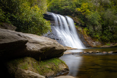
The trail abruptly ends at this outcropping with the waterfall of your left. This is the most photographed view of Silver Run Falls.

    Silver Run Falls Trailhead     There are many pull-outs along this highway that lead to dozens of little known trails in the Nantahala National Forest which end with magnificent mountain vistas or at jaw dropping waterfalls. If you see a random car parked on the side of the road here chances are they’re chasing waterfalls. For this particular hike, we drove 4 miles south of Cashiers until spotting the bright yellow Forest Service sign for Silver Run Falls. Google Maps has the trailhead in their directory so getting here was a breeze. Being early in the evening, we had the place all to ourselves which made it that much more special. At only 0.16 miles long, this trail has one of the best bangs for your buck for all of the scenery that gets packed into such a short duration.      Right off the bat, the gravel trail enters the forest and cuts through an understory of rhododendrons and pines filled with blooming blueberries, mountain laurel, and all other kinds of wildflowers you might expect in early May. The musky scent of wet pine needles mixed with the sweet perfume of the laurels is what I associate most with hiking in the Appalachian Mountains. You’ll pass a small side trail to the left that leads off-trail to another waterfall most visitors are unaware exists, Upper Silver Run Falls. This 20 ft waterfall upstream from the main Silver Run Falls is beautiful in its own right, but requires a hefty hike and dicey vertical scramble to reach. HikingWNC has a great article on this waterfall and how to reach it for anyone interested.     Crossing the Whitewater River     A few short minutes in and you’ll reach the walking bridge spanning the Whitewater River. Up until recently this crossing was merely a simple log, but for safety reasons the Forest Service constructed this sturdy bridge in its place. At this point upstream the Whitewater River is only a dozen feet wide, hinting little as to how enormous this river becomes by the time it reaches Whitewater Falls. Through the trees one can make out Silver Run Falls and hear its booming sound just a skip and a hop away. After crossing the bridge, the trail abruptly ends at a large rock outcropping on the shores of Silver Run Falls large wading pool.      Silver Run Falls      It may not be the tallest or largest waterfall in the Blue Ridge Mountains, but it sure is beautiful. The picturesque scene here screams Western North Carolina. Most people hangout on this outcropping and its the most photographed view of Silver Run Falls I’ve come across. Following the base of the cliff you can walk right up to the precipice of Silver Run Falls and feel the fine misty spray of its 25 ft drop.  Using some of the larger rocks, I made my way across the stream that drains Silver Run Creek into the Whitewater River and landed on the shore opposite the falls. In just a few short weeks this beach will be packed with swimmers bathing in the cool mountain stream and it’ll be impossible to find parking here.   Silver run falls Nantahala National Forest North Carolina hiking trail waterfalls

A slight variation on the classic.

Silver Run Falls 

It may not be the tallest or largest waterfall in the Blue Ridge Mountains, but it sure is beautiful. The picturesque scene here screams Western North Carolina. Most people hangout on this outcropping and its the most photographed view of Silver Run Falls I’ve come across. Following the base of the cliff you can walk right up to the precipice of Silver Run Falls and feel the fine misty spray of its 25 ft drop.  Using some of the larger rocks, I made my way across the stream that drains Silver Run Creek into the Whitewater River and landed on the shore opposite the falls. In just a few short weeks this beach will be packed with swimmers bathing in the cool mountain stream and it’ll be impossible to find parking here.

 Silver run falls Nantahala National Forest North Carolina hiking trail waterfalls

Waterfall chasing doesn’t get much better than this.

Up next, we’re going to tackle a more challenging hike up to another major landmark of the Cashiers and Highlands area, Whiteside Mountain. Rising to an elevation of 4,930 ft, Whiteside Mountain is a notable peak along the Eastern Continental Divide and features prominently in the Cherokee “Legend of the Spear Finger.” Becoming a part of the Nantahala National Forest in the 1970’s, the mountain is surrounded by a handful of unique ecosystems brimming with rare and endangered plants that put on a spectacular wildflower display each spring. The area boasts a 2.0 mile trail that ascends the mountains peak to a dozen stunning overlooks of the surrounding area and views as far south as Georgia and South Carolina. Stay tuned for this upcoming adventure ad as always, see y’all on the trails!

0 comments


Leave a comment

Related Products

Art Loeb Trail Black Balsam Knob Summit Poster
Regular price
$36.00

Art Loeb Trail Black Balsam Knob Summit Poster


Unit price per