

Mooney Falls and Big Laurel Falls are considered some of the tallest and most beautiful waterfalls within the 23,365 acre Southern Nantahala Wilderness. Located only 1.50 miles apart, most visitors to the Standing Indian Area complete the short hikes to these waterfalls together for an easy day of waterfall chasing. Both the Mooney Falls and Big Laurel Falls Trails short hikes are family friendly and packed full of stunning scenery. Difficult to reach by road, this area contains over 30 miles of the Appalachian Trail and is just a stones throw from Pickens Nose famous ledge.
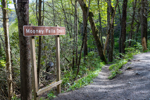
Mooney Falls Trail | 0.15 Miles
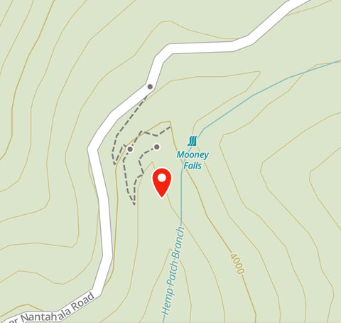
Mooney Falls Trailhead Location | Google Maps
Short 0.15 mile route to Mooney Falls via Gaia App.
Getting There
The Southern Nantahala Wilderness along with the western most corner of the Nantahala National Forest are some of the least talked about regions of North Carolina, yet they packed some of the tallest waterfalls and most scenic stretches of mountain vistas in the Southeast. On a recent trip to Franklin, North Carolina to explore the Wayah Bald Lookout Tower, Rufus Morgan Falls, and Pickens Nose, I etched out a spot in my itinerary to pay a visit to these two out of the way gems. Entering the outer perimeter of the Southern Nantahala Wilderness along Ball Creek Rd (Forest Road 83) from the Cowee Hydrological Lab, we drove 5 miles west along the gravel road to the summit of Pickens Nose and veered left onto Standing Indian Campground Rd another 3 miles on our descent to the valley floor to reach the Mooney Falls Trailhead. There isn’t much of a pull-off here with parking consisting of just a few spots along the shoulder. Not to worry though as this backcountry area sees little traffic even during the busy summer season.
No real trailhead here so if you're not on the lookout for the Mooney Falls Trail you might just miss it.

Its a 100' ft descent from the road straight down to Mooney Falls.
Mooney Falls Trail (0.15 Miles)
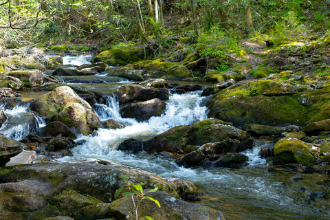
The Mooney Falls Trail sign is easy to miss if you’re not looking for it. Pointing to a narrow path descending directly below Standing Indian Campground Rd the trail follows a series of switchbacks down into the deep valley bordering the Southern Nantahala Wilderness. While this trail is a super short 0.15 miles long, it does carry a hefty 100 ft descent to the banks of Hemp Patch Branch that must be retraced back to the parking area. With the sounds of crashing water becoming louder with each step, the trail hits a fork with the main path heading straight to the Upper Cascades of Mooney Falls. A boulder perched high above the creek here offers the best views of the northern most stretch of Mooney Falls and its precipice below. This photogenic portion of Hemp Patch Branch, surrounded by lush thickets of rhododendrons, is often mistaken for the main drop. Curving down the steep hillside above, the 35 ft long cascades when taken into consideration, mark this as a 50 ft tall waterfall.

The 35' ft tall cascades above Mooney Falls might be the most photogenic part of this trail.
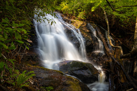
Hemp Patch Branch fans out as it drops over Mooney Falls to create this gorgeous fanning effect.
Mooney Falls & Cascades (15’ ft -50’ ft)
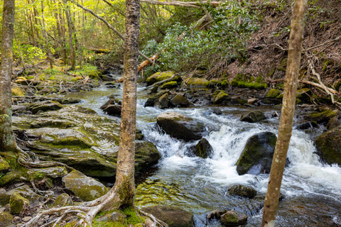
Retracing our steps back to the fork, we take the path down to see the actual Mooney Falls up close. Ending directly below where we were just standing near the cascades, Mooney Falls 15 ft drop is so close that we can stretch our arms out and touch it. There is a small viewing area here amongst the boulders with a side path hugging the side of the cliff all the way to the waterfall itself. As Hemp Patch Branch nears the precipice of the main falls, the creek widens out to give us a gorgeous fanning effect as Mooney Falls tumbles down a series of rough ledges. Unlike the clean view of the cascades, the drop is littered with some debris that partially obscure the water flow. This waterfall does not have a natural pool at its basin like most of the ones found in the area. Hemp Patch Branch continues its downhill trajectory another couple of miles until it reaches the headwaters of the Nantahala River at our next stop, Big Laurel Falls.
Big Laurel Falls Trail | 0.50 Miles
Big Laurel Falls Trailhead Location | Google Maps

Nice overview of Big Laurel Falls Trail at the headwaters of the Nantahala River gorge.
The Trailhead
It is a little over a 1 mile drive from the Mooney Falls Trailhead to the much larger and heavily visited Big Laurel Falls Trail. This trailheads spacious parking area and large signs owe its popularity to being one of the main access points for the Appalachian Trail in the Standing Indian Basin. It is a short descent from the parking area to a quick trail junction with the Big Laurel Falls Trail continuing on the RIGHT. If you were to cross the creek here and go left, you would be thrusted onto a challenging 2.3 mile journey along the Timber Ridge Trail to its confluence with the Appalachian Trail near Carter Gap and the Georgia state line. After crossing an expansive bridge over the last stretch of Hemp Patch Branch, the rest of this 0.5 mile trail is a straight shot.
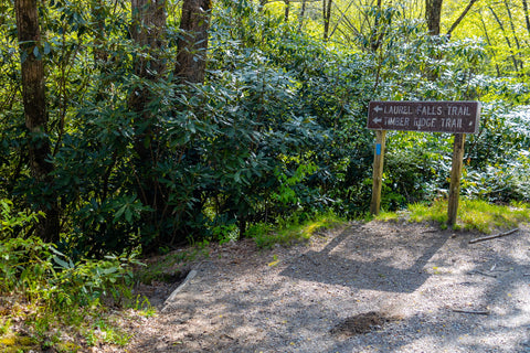
Big Laurel Falls shares its trailhead with the 2.3 mile Timber Ridge Trail which is the main access point to the Appalachian Trails 30 mile jaunt through the Southern Nantahala Wilderness.
The rapids and cascades of the Nantahala River looking similar to those of the Great Smoky Mountains, but much wilder and less crowded.

Bridge crossing Hemp Patch Branch and the official beginning of the Big Laurel Falls Trail.
Big Laurel Falls Trail (0.5 miles)
The Big Laurel Falls Trail is one of only two trails in the Southern Nantahala Wilderness, the other being the Deep Gap Branch Trail, that explores deep within the lush valleys of this isolated region. While most people that venture into the area do so for the expansive mountain top views, down here we’re treated to the wild and tumultuous cascades of the Nantahala River. Named “Land of the Noonday Sun” in the Cherokee language, this river pierces deep through a heavily forested and narrow gorge with areas that only receive sunlight when the sun is directly overhead. Despite hiking this trail early in the afternoon on a bright and sunny day, down here it feels much later and closer to dusk than it actually is. During the colonial era, a specific sect of the Cherokee People occupied this river valley in sprawling settlement communities known as Valley Towns.

Easy and family friendly 0.50 mile trail.
There are many spots along the Big Laurel Falls Trail to stop and enjoy the rugged and unspoiled scenery.
Big Laurel Falls (25’ ft)
This is a very pretty trail with many spots along the way where you can walk down onto the river bank to catch a photogenic view of the rapids swirling over boulder lined embankments. The scene reminds me a lot of the Great Smoky Mountains, but much wilder and without the crowds. After a short 15 minute walk the sound of Big Laurel Falls will become much more apparent as you quickly catch sight of it at the head of the valley. This is the spot where Kilby Creek, Gulf Fork, and Big Laurel Branch all meet to form the Nantahala River with Big Laurel Falls as the crowning jewel. At 25’ ft tall, this waterfall has a steep, but short drop before sliding down gracefully into a natural pool. A middle ledge between the two drops has some interesting rock formations and is filled with potholes where you can easily photograph some swirls. Being just after midday, the sun is directly overhead, ruining any chance I might have of a productive photo session. Still, I can’t help but enjoy my time here while admiring the beautiful surroundings that not many people will ever get to see.
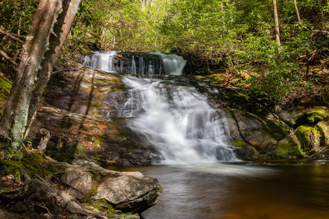
Our first view of Big Laurel Falls 25' ft drop at the headwaters of the Nantahala River.

Up close view of the top ledge and slide of Mooney Falls.

They don't call it The Land of the Noonday Sun for nothing! Despite it only being 1 pm the deepening shadows make it seem much closer to dusk than it actually is.
Up next, were headed north into Virginia to check out some of the trails along the northern terminus of the Blue Ridge Parkway. Known as some of the most photographed landmarks along the Appalachian Trail, we’ll be tackling the strenuous hikes up to McAffee Knob and The Dragons Tooth. Stay tuned for these upcoming articles and as always, see y’all on the trails!


0 comments